
Pierre-Perthuis
| Pierre-Perthuis | ||
|---|---|---|
|
||
| region | Bourgogne-Franche-Comté | |
| Department | Yonne | |
| Arrondissement | Avallon | |
| Canton | Joux-la-Ville | |
| Community association | Avallon, Vezelay, Morvan | |
| Coordinates | 47 ° 26 ' N , 3 ° 48' E | |
| height | 151-279 m | |
| surface | 7.34 km 2 | |
| Residents | 122 (January 1, 2017) | |
| Population density | 17 inhabitants / km 2 | |
| Post Code | 89450 | |
| INSEE code | 89297 | |

Pierre-Perthuis is a French commune with 122 inhabitants (as of January 1, 2017) in the Yonne department in the Bourgogne-Franche-Comté region (before 2016 Bourgogne ) in eastern France . The municipality belongs to the Arrondissement of Avallon and the canton of Joux-la-Ville (until 2015 Vézelay ). The inhabitants are called Perthuisiens .
geography
Pierre-Perthuis is located about 46 kilometers south-southeast of Auxerre on the Cure . Pierre-Perthuis is surrounded by the neighboring communities of Saint-Père in the north and north-west, Menades in the north-east, Domecy-sur-Cure in the south and east, Fontenay-près-Vézelay in the south-west and Foissy-lès-Vézelay in the west.
Population development
| year | 1962 | 1968 | 1975 | 1982 | 1990 | 1999 | 2006 | 2013 |
|---|---|---|---|---|---|---|---|---|
| Residents | 71 | 77 | 73 | 72 | 70 | 104 | 118 | 136 |
| Source: Cassini and INSEE | ||||||||
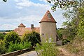
Attractions
- Saint-Léonard church
- Castle ruins from the 12th century
- Fixed house from the 16th century
- Bridge over the Cure

Saint-Léonard church
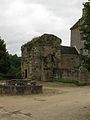
Castle remains

Bridge over the Cure
Fixed house


Web links
Commons : Pierre-Perthuis - Collection of images, videos and audio files