
Yrouerre
| Yrouerre | ||
|---|---|---|
|
||
| region | Bourgogne-Franche-Comté | |
| Department | Yonne | |
| Arrondissement | Avallon | |
| Canton | Tonnerrois | |
| Community association | Le Tonnerrois en Bourgogne | |
| Coordinates | 47 ° 48 ' N , 3 ° 57' E | |
| height | 205-331 m | |
| surface | 14.28 km 2 | |
| Residents | 159 (January 1, 2017) | |
| Population density | 11 inhabitants / km 2 | |
| Post Code | 89700 | |
| INSEE code | 89486 | |

Yrouerre (1801 still with the spelling Yrrouer ) is a French commune in the Yonne department in the Bourgogne-Franche-Comté region . It belongs to the Arrondissement Avallon and the municipal association Le Tonnerrois en Bourgogne, founded in 2014 .
geography
The municipality of Yrouerre, with 159 inhabitants (January 1, 2017), is located 30 kilometers east of Auxerre on a plateau between the valleys of the Yonne and Serein rivers .
The community area of 14.28 km² is characterized by large arable land. Forests make up about a tenth of the municipality's area.
The TGV route of the LGV Sud-Est , which connects Paris with Lyon , runs five kilometers northeast of the village .
Neighboring municipalities of Yrouerre are Tonnerre in the north, Sambourg in the east, Fresnes in the south-east, Annay-sur-Serein and Môlay in the south, Sainte-Vertu in the south-west, Poilly-sur-Serein in the west and Viviers in the north-west.
| year | 1962 | 1968 | 1975 | 1982 | 1990 | 1999 | 2007 | 2016 | |
| Residents | 143 | 161 | 152 | 136 | 161 | 197 | 203 | 162 | |
| Sources: Cassini and INSEE | |||||||||
Attractions
- Saint-Nicolas church with choir and tower classified as a monument historique
- 18th century lavoir
- Only the orangery remains of the former castle . The site was also included in the list of architectural monuments worthy of protection. The orangery once stood in the palace, which was built in the 17th century. The orange trees blossomed from 1767 along the main facade protected from frost from the pilasters of the blind arcades . Between May and September, artists show their work in the orangery.
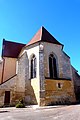
Saint-Nicolas church
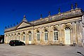
Orangery of the former castle


Economy and Infrastructure
There are 13 farms in the municipality (mainly grain cultivation, two winegrowers).
Yrouerre is on the D944 from Tonnerre to Avallon .
supporting documents
- ↑ toponym on cassini.ehess.fr
- ↑ Yrouerre on cassini.ehess.fr
- ↑ Yrouerre on insee.fr
- ↑ Entry in the Base Mérimée (French)
- ↑ Pictures of the lavoir
- ↑ Entry in the Base Mérimée (French)
- ↑ Farms on annuaire-mairie.fr (French)