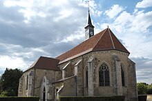
Flogny-la-Chapelle
| Flogny-la-Chapelle | ||
|---|---|---|

|
|
|
| region | Bourgogne-Franche-Comté | |
| Department | Yonne | |
| Arrondissement | Avallon | |
| Canton | Tonnerrois | |
| Community association | Le Tonnerrois en Bourgogne | |
| Coordinates | 47 ° 57 ' N , 3 ° 52' E | |
| height | 112-183 m | |
| surface | 23.75 km 2 | |
| Residents | 1,029 (January 1, 2017) | |
| Population density | 43 inhabitants / km 2 | |
| Post Code | 89360 | |
| INSEE code | 89169 | |
| Website | http://flogny-la-chapelle.fr/ | |
Flogny-la-Chapelle is a French commune with 1,029 inhabitants (as of January 1 2017) in the department of Yonne in the region Bourgogne Franche-Comté . It belongs to the Arrondissement Avallon , the canton Tonnerrois (until 2015: Canton Flogny-la-Chapelle ) and the municipality association Le Tonnerrois en Bourgogne . The residents call themselves Capello-Floviniens .
geography
Flogny-la-Chapelle is located about 28 kilometers northeast of Auxerre on the Armançon and the Canal de Bourgogne . Flogny-la-Chapelle is surrounded by the neighboring municipalities of Les Croûtes in the north, Chessy-les-Prés in the northeast, Marolles-sous-Lignières in the east, Bernouil and Dyé in the south, Carisey in the southwest, Villiers-Vineux in the west and southwest and Percey in the West.
Population development
| year | 1962 | 1968 | 1975 | 1982 | 1990 | 1999 | 2006 | 2013 |
| Residents | 410 | 473 | 1,137 | 1,082 | 1,070 | 1,099 | 1.010 | 1,023 |
| Source: Cassini and INSEE | ||||||||
Attractions
- Saint-Léger church
- Saint-Hubert church
- old cheese factory

