
Canal de Bourgogne
| Canal de Bourgogne | |
|---|---|
 Canal de Bourgogne near Fulvy |
|
| Water code | FR : F3-0172 , FR : ---- 0172 |
| location | France , Bourgogne-Franche-Comté and Grand Est regions |
| length | 243 km |
| Built | 1775-1843 |
| class | I ( Freycinet class ) |
| Beginning | Branch from the Yonne at Migennes |
| The End | It flows into the Saône in Saint-Jean-de-Losne |
| Descent structures | 190 |
| Ports | Migennes , Saint-Florentin , Tonnerre , Montbard , Pouilly-en-Auxois , Dijon , Saint-Jean-de-Losne |
| Used river | Armançon , Brenne , Vandenesse , Ouche |
| Outstanding structures | Pouilly-en-Auxois summit tunnel |
| Kilometrage | Towards the Saône |
 |
|


The Canal de Bourgogne (German: Burgundy Canal ) is a shipping canal that runs almost exclusively in the French region of Bourgogne-Franche-Comté , but also briefly touches the neighboring region of Grand Est . With its length of 243 kilometers, it connects the Yonne with the Saône and thus the Atlantic with the Mediterranean via other rivers and canals .
Course and technical infrastructure

The watershed- type canal begins its ascent at Migennes on the Yonne at an altitude of around 80 meters above sea level . After 158 kilometers and overcoming 115 locks (114 locks in effect, since the first two were merged in Migennes), it reaches the top at 376 meters at Pouilly-en-Auxois . From here the canal is led through a 3333 meter long tunnel , the Voûte de Pouilly-en-Auxois , which crosses the main European watershed between the Mediterranean and the Atlantic. After descending through another 76 locks over a distance of 92 kilometers, the canal at Saint-Jean-de-Losne reaches the Saône at an altitude of about 180 meters.
The locks are numbered on both sides of the apex tunnel, starting in Pouilly-en-Auxois in the direction of Migennes, and immediately after the tunnel at the Escommes lock in the direction of Saint-Jean-de Losne, and with the addition (also on the kilometer stones on the towpath) " Y ”(side of the Yonne) or“ S ”(side of the Saône). The smallest distance between two locks is 201 meters (between locks 37 Y Pouillenay 1 and 36 Y Chassey 6, at km 122), the largest 10 kilometers (between locks 13 Y Pont-Royal and 12 Y Gissey, km 137 and 147 ).
- Lock dimensions : 39 x 5.10 m ( Freycinet dimensions )
- Max. Draft : 1.80 m
- Minimum clearance: 3.40 m at normal water level (only 3.10 m in the Pouilly tunnel)
Coordinates
- Starting point of the canal: 47 ° 57 ′ 39 " N , 3 ° 30 ′ 6" E
- End point of the canal: 47 ° 6 ′ 4 ″ N , 5 ° 15 ′ 35 ″ E
Crossed departments
- Yonne
- Côte-d'Or
- Aube for about 1 kilometer at Marolles-sous-Lignières
Places on the canal
- Migennes
- Brienon-sur-Armançon
- Saint-Florentin
- Flogny-la-Chapelle
- Dannemoine
- Tonnerre
- Tanlay
- Argenteuil-sur-Armançon
- Ravières
- Rougemont
- La Grande Forge near Buffon (= the model forge , built in 1768 by the great naturalist Georges-Louis Leclerc, Comte de Buffon)
- Montbard
- Venarey-les-Laumes
- Alise-Sainte-Reine (excavation of the Gallo-Roman city of Alesia )
- Flavigny-sur-Ozerain
- Pouilly-en-Auxois : This is where the apex tunnel of the Canal de Bourgogne is located
- Châteauneuf
- La Bussière-sur-Ouche with the former Cistercian Abbey of La Bussière
- Dijon , capital of Burgundy
- Saint-Jean-de-Losne
history

The first plans for this canal go to King Ludwig XII. (1498–1515) and King Francis I (1515–1547) back; they wanted to create a water link between the English Channel / Atlantic and the Mediterranean. In 1511 a study was drawn up to make the river Ouche navigable between Dijon and the Saône, about 30 km. In 1530 Franz I gave the order to start work. But the Wars of Religion ruined both the country and the project. In 1603 the Minister Sully commissioned the person responsible for the dams in the kingdom, the Dutchman Humphrey Bradley, with the re-planning of the mentioned section. However, Bradley developed the original 16th century plan to connect the Yonne and Saône rivers. The city of Dijon resisted, as it would lose its function as a transfer station and thus many jobs and income.
Nevertheless, in 1606, during the reign of Henry IV (1589–1610), serious planning of this waterway began again. Among other things, an alternative was examined that would have roughly corresponded to the current course of the Canal du Center , but nothing else happened. In 1676 the Minister Colbert commissioned the builder of the Canal du Midi, Pierre-Paul Riquet , with an expert opinion; Riquet thought the project was unrealizable. Vauban described in an expert report in 1696 the various ways in which the seas could be connected. But another 28 years passed unused. The Burgundian administration commissioned the engineer Joseph Abeille on May 18, 1724 to draw up the plans for a waterway between the Yonne and the Saône. The condition was that the apex posture was established at Pouilly-en-Auxois.
The plans with a route that later looked very similar to the actual route were completed in 1727, and an expert report in 1752 showed that the water supply of the canal was better guaranteed on the route via Pouilly-en-Auxois than on the route of the Canal du Center. But more decades had to pass before Louis XV in 1773 . signed an edict ( confirmed by Louis XVI a year later ) according to which the canal was to be built. The king's budget would finance the part between Migennes and Pouilly-en-Auxois, while Burgundy had to take over the part between Pouilly-en-Auxois and Saint-Jean-de-Losne. The total cost was estimated at 7,179,000 livres. At the same time as the Canal de Bourgogne, the Canal du Charolais (now Canal du Center) and the Canal were commissioned by Franche-Comté.

In 1775 the first preparatory work began between the Yonne and Tonnerre . On the side of the Saône one did not begin until 1781. Due to the simultaneous construction of the Canal du Center under the chief engineer of the Ponts et Chaussées of Burgundy, Emiland-Marie Gauthey, the financial means were very limited, so one on the side of the Saône initially only built the section from Saint-Jean-de-Losne to Dijon. This was handed over to its destination on December 14, 1808. During the revolution, until 1793, the building site that continued the canal to Pont-de-Pany was abandoned, and during the reign of Napoléon Bonaparte from 1807, construction progressed very slowly. The 20 km long section from Dijon to Pont-de-Pany was completed in 1814, then work was suspended again until 1822. At the instigation of the chief engineer for roads and bridges, Joseph-Michel Dutens, and the general director for roads and bridges Bridging, Louis Becquey, the Compagnie de l'Emprunt du Canal de Bourgogne, a public limited company for the issuance of government bonds, was founded in that year to enable the canal to be completed.

On December 28, 1832, the first canal ship entered the summit tunnel; it reached Dijon on January 3, 1833. At the end of 1843, after the completion of the five barrages at Cercey, Chazilly, Grosbois, Le Tillot and Panthier for the water supply to the apex at Pouilly-en-Auxois, the canal was completely ready for use. When the railway line between Dijon and Laroche Migennes went into operation piece by piece in 1851, the economic importance of the Canal de Bourgogne became very small. Nevertheless, the canal was technically improved until 1882. The Freycinet standard was also introduced and an additional reservoir was built on the Armançon. Of the 6 reservoirs with a total capacity of 30.5 million cubic meters, three each feed the Yonne and Saône sides of the canal, via trenches with a total length of 70 km, some of which are underground.
In 1873 a steam-powered towbar was tested for the first time in France on the Canal de Bourgogne . In 1911 the first attempts were made to tow a tractor with a combustion engine .
The Canal de Bourgogne is one of the examples of how, due to the endless delays in the construction, the completion of the canal almost coincided with the construction of the railway lines, so that economic use was only possible for a short time. The Migennes - Dijon railway line runs largely parallel to the canal, over long stretches at a distance of just one kilometer, so that it has the same catchment area as the canal. The channel was therefore only unrivaled for a few years.
Pouilly-en-Auxois summit tunnel

Every canal that crosses a watershed needs a sufficient flow of water throughout the year in the apex position . In addition, the vertex should be long enough or must be supplemented by reservoirs so that the loss of water through the locks of the ships is not noticeable. On the Bourgogne Canal, the apex posture is 6 km long. Due to the terrain, this length could only be achieved through a tunnel . This is 3333 m long and straight, so that you can see the other end from one end. It lies up to 34 m below the surface of the earth. As far as possible, the canal was led open in a cut towards the tunnel. Above the tunnel is an avenue with a bike and walking path.
The tunnel was built between 1826 and 1832, first by civilian convicts, and then by Spanish and English prisoners of war during the German Empire. First, 32 ventilation shafts were dug from the surface along the route (11 of them can still be seen today; they measure around 2 m in diameter and protrude around 3 m above the ground on the surface). From each shaft the tunnel was driven on both sides; the rubble was removed via the shafts. Then the tunnel was lined. In the tunnel, the channel is 6.20 m wide and the apex is 3.10 m above the water surface. The tunnel is approached on both sides through long incisions with steep walls.
There is no towpath in the tunnel; walking or driving along the edge is prohibited. Originally, the sailors had to poke their ships through the tunnel using poles , and later pull them along a chain attached to the tunnel wall. It took up to 8 hours to cross the tunnel in this way. The capacity of the tunnel was correspondingly small, even when driving in convoys. Since it was impossible to meet in the tunnel, the passage was regulated with a "timetable", it was a 24-hour operation.
_-_Remorqueur_Electrique_sortant_du_tunnel_du_Canal_Bourgogne.jpg)
In 1867 a steamboat was put into operation, with which several ships were pulled through the tunnel at once. This steamboat sailed day and night: at 6 a.m. and 6 p.m. it left Pouilly-en-Auxois, at 12 noon and midnight it left the lock of Escommes (Saône side). In 1893 the company was electrified. Two hydroelectric power plants produced electricity, and the chain tractor (French: toueur) now drove electrically, with two pantographs to two of the three contact wires attached under the top of the tunnel. The chain tractor pulled itself along a chain lying on the canal floor, which was guided over a drive gear on the tractor. He could pull 5 loaded or 15 empty boats. The passage between the ports of Pouilly-en-Auxois and Escommes took two hours at a speed of around 3 km / h.
After the First World War , more and more ships with their own engines came into operation, so that the tug operation was discontinued between the two world wars. The tug definitely made its last voyage in 1987. Today it is on display at the port of Pouilly-en-Auxois and can be viewed from the outside. There is an exhibition about the canal nearby, including a model of the tug.

Near the first lock on the Saône side, at the southern end of the outer port in Escommes, an interesting facility can be seen right next to the canal: a pool that can be locked with gates and has a sunken floating dock called a “bac” . Since on the one hand the overhead lines in the tunnel, which were necessary for the electric chain tractor, restricted the already low passage height to only 3.10 m, on the other hand the peniches had also become higher, the Bac was used from 1910 to empty peniches that were used for the The tunnel passage floated up too much to lower it by 60 cm. This was possible because the heavy construction of the Bac meant that the peniches lay deeper in it than when they drove independently.
To load the too high lying peniche, the bac was lowered to the bottom by opening the gates so that the peniche could be pulled over it with a winch. Then the gates of the basin were closed and the water in the basin and in the bac was drained through a pipe leading into a ditch. This lowered the peniche to the bac at the bottom. Now the gates of the Bac were closed and the basin from the canal was flooded again so that the Bac with the loaded peniche floated up and could be placed in the tunnel towing train. In contrast to the basin, the Bac did not require a movable entrance gate, but only a fixed threshold that was high enough above the water when the Bac was floating and deep enough under water when the Bac was lowered so that an empty peniche could pass over it.
Although the process did not require any pumps, it was quite complicated and time-consuming, so that in the last few days of tugging in the tunnel, when the traffic on the canal had slackened significantly, the Bac sometimes no longer used the bac at all, but empty penichen through the Tunnels by simply lowering the water level in the apex position for a short time. It is not known exactly when a peniche was last towed through the tunnel with the Bac. While the basin with the Bac in Escommes sunk into it is still there, only the front half of the basin with the entrance gate can be seen on the other side of the tunnel in the port of Pouilly. The back half of the basin for the Bac was filled in to build the exhibition hall for the former chain tractor.
Today the passage through the tunnel is regulated as follows: You report to the lock keeper of the last lock before the tunnel. This clarifies with the colleague (or the colleague) at the other end of the tunnel whether the tunnel is free. If this is the case, the lock keeper gives the skipper a written permit. The passage must then be carried out immediately and ended within a specified period of time. In this way, it is possible to enter the tunnel at any time during operating hours without having to wait for convoys to form.
Economical meaning


Today the canal is no longer of economic importance, it is almost only used by tourists with pleasure boats and houseboats as well as hotel ships (converted barges). It has a certain additional meaning thanks to the continuous, almost consistently good and wide towpath, which is actively used by cyclists who drive along the canal.
In terms of economic importance, the opening of a canal in the 19th century corresponded to the opening of an important motorway in the 20th century. Canals like the Canal de Bourgogne attracted a multitude and great variety of trades and professions that were necessary for their operation, and they made it possible for the first time to export products from the region along the canal, not least to Paris. The Canal de Bourgogne was a great success from the start. In 1836, 2360 passing barges were counted in Dijon, 1259 in Pouilly-en-Auxois and 1347 in Tonnerre. Mainly coal, timber, wine, wrought iron from the forges along the canal (Buffon, Aisy, Fraugey), natural stones for various uses, lime, cement, sand, gravel and, last but not least, grain and sugar. Not everything was transported along the entire length of the canal; many ships only ran between towns along the canal.
The canal meant that numerous companies settled in its vicinity. Especially the quarries - you can still see them today, most of them abandoned, along the canal z. B. in the Ravières area - experienced an enormous boom. The villages and towns along the canal and ultimately the entire region also benefited from this upswing.
But because the canal was opened too late, it soon experienced a decline. The competition from the railroad was too strong. After the opening of the Migennes - Dijon railway line, the tonnage carried on the canal fell suddenly from 200,000 to 125,000 t. The transport volume then increased again over the years, but to a much lesser extent than with the railroad. The extension of the canal to the Freycinet standard, which came too late, as well as the acceleration of the passage through the apex tunnel at Pouilly-en-Auxois could not stop the relative and absolute decline. The First World War dealt the first severe blow to canal shipping. Numerous young men who worked on and by the canal were drafted and fewer transports were made. After the war the tonnage increased again to 800,000 t, but the Second World War was another blow, from which the canal no longer recovered. In the meantime, road traffic had also become a strong competitor. In 1980 400,000 t were still transported on the Canal de Bourgogne, most of it between Dijon and the Saône. Hardly any load was transported over the entire length of the canal; this was most likely the case with grain. Between 1980 and 1995, tonnage fell by 90%. Today it is completely meaningless, if it still exists at all.
The Canal de Bourgogne was just so long in a profitable operation that it did not disintegrate as a structure until tourist shipping emerged. British ship rental companies in particular began to settle on the canal after having had good experiences on the Canal du Midi. Today the Canal de Bourgogne is very popular with houseboat renters, but this use, which is heavily focused on the summer months, is not of great economic importance.
Canal de Bourgogne in Dijon

Houseboat EauVive 930 entering a lock

Houseboats on the canal

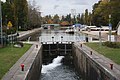
Empty lock chamber

Lock 82 Argenteuil, lock keeper's house


Remarks
See also
literature
- Catherine Parinet (texts) / Alain Parinet (photographies): Les canaux de Bourgogne . Itinéraires de découvertes. Editions Ouest-France, 2009. ISBN 978-2-7373-4673-6 .
- Angelika Maschke and Harald Böckl: Burgundy Canal: traveling by houseboat. The Burgundy Canal from Migennes to St-Jean-de-Losne. 2nd edition Edition Hausboot Böckl, 2007. ISBN 978-3-901309-18-2 .
- With the houseboat through Burgundy. Burgundy Canal, Nivernais Canal, Yonne, Loire Lateral Canal, Center Canals, Saône, Seille, Doubs, Canal du Rhône au Rhin, Marne-Saône Canal. 4th edition Edition Böckl, 2006. ISBN 978-3-901309-04-5 .
- Josette Chevolleau; Jacques Clouteau: Le canal de Bourgogne. Randonneur Guide . Editions du Vieux Crayon, 2005 with “additif 2008”. ISBN 978-2-9516797-6-4 .
Web links
- Canal de Bourgogne. In: Structurae
- Information on the channel in the Babel project (French)
- Le canal de Bourgogne à vélo
- Burgundy Canal Information Center: The Pouilly-en-Auxois vaulted tunnel
Individual evidence
- ↑ a b The information on the canal length is based on the information on the Canal de Bourgogne (ascent to vertex posture) at SANDRE (French) and the Canal de Bourgogne (descent from vertex posture) at SANDRE (French), accessed on November 28, 2011, rounded on full kilometers.
- ↑ Gérard Bianchi: Les Cahiers du Musée de la Batellerie. La traction mécanique sur berge en France . Association des amis du Musée de la Batellerie, Conflans-Sainte-Honorine 2015, ISBN 2-909044-69-6 , p. 2 .
- ^ McKnight, Hugh: France's rivers and canals. Manual for inland skippers. Verlag Rheinschiffahrt, Bad Soden / Ts. 1989, p. 222 .