
Alesia


The originally Gallic oppidum Alesia was the capital of the Mandubians , a Gallic tribe associated with the powerful Haeduern . It was located in central France on the summit of Mont Auxois, on a plateau about two kilometers long and a maximum of 700 meters wide at an altitude of 400 meters above sea level, extending in an east-west direction. NN. on the site of today's French commune of Alise-Sainte-Reine in the center of the Côte-d'Or département in the Burgundy region , see a graphic below that describes Caesar's campaigns in Gaul. Alise is the oldest place identified with the Celtic oppidum Alesia, although this identification took place as early as Carolingian times and has been confirmed by archaeological finds in modern times.
First excavations under Napoleon III. (1808–1873) identified clear traces of Roman siege works that took place in the course of the Battle of Alesia in 52 BC. BC by Gaius Iulius Caesar were built in this place. Napoleon had a large statue erected on the western corner of the plateau to represent the Gallic general Vercingetorix . The bronze figure was created by the sculptor Aimé Millet , the base comes from the historian Eugène Viollet-le-Duc .
Gallic origins
The steep limestone cliffs surrounding the Alesia offered the settlement a natural defensive structure, as was the case with most of the hills on the surrounding plateau. The place was therefore particularly suitable for human settlement. The Gallic oppidum was one of the largest Gaul with about 97 hectares and had been at least since 80 BC. Chr., Towards the end of the Latène period , permanently inhabited. The well-fortified cliffs, especially in the west, and their breaches caused by erosion, were supplemented and reinforced by raised stone walls. In the east and south-west of the plateau fortified entrance portals were built, as they are known from the fortifications of Murus Gallicus , such as Bibracte .
Gallic living spaces (settlements) like these were built from light materials, from load-bearing columns and wooden frames, clay walls made of wickerwork with straw clay, thatched roofs and clay floors. Their archaeological evidence is often rare and scanty because these materials leave only a few traces through weathering. In any case, they are documented for Alesia.


The entire urban ensemble was structured by paved axial roads. What is certain is that communal forms of living in the middle of the oppidum were grouped around a main temple.
To the north, a strong palisade enclosure gave an indication of an important room, probably another sanctuary. Such a room was always set up in the Gallic era in honor of a local god. Here it was Ucuetis , a craftsman god , evidenced by a found Gallic dedicatory inscription. Metallurgy, presumably using bronze and iron, was obviously a valued handicraft here and seemed to have had a decisive place in the oppidum's economy.
Another Gallic sanctuary was apparently at the eastern end of the plateau, but outside the defensive system. It lay at a spring and was dedicated to another Gallic god, the god Moritasgus . Moritasgus is a Celtic name for a healing god found in a vault near Alesia. In two inscriptions he is identified with the Greco-Roman god Apollon . His wife was the goddess Damona .

The dedication to the gods suggests the presentation of a shrine at the healing spring, where sick pilgrims could bathe in holy water. The sanctuary is said to be located near the east portal of Alesia in front of the gates of the city wall, impressive with its baths and a temple. There were also pillared halls in which the sick slept, presumably in the hope of divine visions and healings.
The pilgrims made numerous votive offerings to Moritasgus. These were small models of the diseased body parts such as limbs, internal organs, genitals, breasts and eyes. Surgeons' tools were also found, suggesting that the priests also performed medical procedures. The name Moritasgus comes from the first century BC. BC, was in use by the Senones and is interpreted differently. It probably means "super badger" or "sea badger". The European badger produces a secretion that was used in Gallic medicines, resulting in a healing connection with the god.
Gallic dedicatory inscription , dedicated to the craftsman god Ucuetis from the 2nd century AD, with the name of the city ALISIIA ( Gallic Alesia): It reads in German:
"Martialis, the son of Dannotalus, consecrated this sanctuary to the Ucuetis together with the metalworkers who worship this god in Alesia."
The most spectacular discovery of the last few years (1994) concerns the murus gallicus of Alesia near what is now the small settlement of En Curiot near the current entrance to the statue of Vercingetorix . Excavations there uncovered a significant part of the wall, a low point of the defensive work. These structures connected to the site suggest that the west portal of the oppidum was in this sector. On the inside of the rampart, the remains of five Gallic houses have been discovered, arranged in an area around a small, empty room. Both the buildings themselves and the ample homogeneous crockery, such as Campanian and Gallic ceramics, Italian wine amphoras , but also fibulae and fragments of iron weapons (arrowheads, sheaths of swords and shields) are dated to a time before the battle of 52 BC. All of this was found in an area of the oppidum that was densely populated during the siege of Alesia. At that time, a strategic trade route from the English Channel to the Mediterranean also ran over the hill of Alesia.
The conquest of Gaul


The Gallic War (lat. Bellum gallicum ) took place between the years 58 and 53 BC. Instead of. Roman legions of various numbers under the leadership of the general Gaius Iulius Caesar (* 100 BC; † 44 BC) marched in the summer months against numerous Gallic tribes, whose fighters had mostly come together in groups, but also fought individually, where they were mostly subordinate to different leaders. The Roman military successes came very quickly, and the Romans penetrated as far as Britain in the following years . The battle for the Gallic oppidum Gergovia alone at the beginning of 52 BC. BC ended with Caesar's strategic retreat. The Gallic leader Vercingetorix (* approx. 82 BC; † 46 BC in Rome) had shortly before been given the supreme command of the fight against Caesar by most of the Gallic tribes in the Oppidum Bibracte .
The Battle of the Armançon was a cavalry battle between Caesar's Germanic cavalry and that of Vercingetorix in the late summer of 52 BC. BC on the Armançon River. Vercingetorix evaded the superior Roman cavalry by entrenching himself with his troops in the well-fortified Gallic Alesia 14 kilometers away. He set up a Gallic camp at the eastern foot of the plateau outside the fortifications of the Gallic oppidum, which extended between the two rivers. Caesar pursued the fleeing Gauls and enclosed them with extensive siege works around Alesia. Vercingetorix commanded about 20,000 and Caesar about 70,000 soldiers. However, Vercingetorix succeeded in sending his cavalry away before the enclosure, as they would have unnecessarily strained the supplies during a siege. The horsemen were also given the task of calling the Gallic tribes to form a relief army .
Caesar's fortifications in front of Alesia - Cueni:
Caesar himself quickly became besieged, since he was now also surrounded by the advancing Gallic relief army. With extensive fortification work , Caesar erected a 16 km long inner siege ring ( circumvallation ) and a second, 21 km long, outwardly directed defense ring ( contravallation ) within only six weeks (on the map below the names of the siege rings are used the other way round), to fight off these enemies. These entrenchments contained towers, traps, trenches, ramparts, footbars and barriers against cavalry attacks.
Already after about thirty days the food ran out in Alesia. Vercingetorix sent all those unable to fight, such as the elderly, women and children, from the city because they could no longer be fed. In De Bello Gallico , Caesar bluntly reports his decision not to let civilians go through his lines, so that they died slowly and painfully in front of everyone.
The arrival of the Gallic relief army at Alesia and the subsequent attack was the signal for Vercingetorix to attempt an escape. Through determined advances and clever organization of the troops, Caesar and his deputy Titus Labienus succeeded in that "battle on two fronts" both in repelling attempts to break out of Alesia and in keeping the outer Gallic army away. After Caesar's Germanic horsemen had dispersed the relief army, it gathered again and attacked a weak point in the outer fortification. The Gallic armies broke through the fortifications and attacked the Roman troops from the front and behind. Caesar motivated the Roman legions by appearing on the battlefield, took four cohorts and led them into battle. At the same time, he ordered some cohorts to circumvent the battlefield extensively.
When the Roman troops fell in the rear of the Gaulish armies, the Gauls fled, but were persecuted by the Romans for a while. Vercingetorix withdrew to Alesia when he received news of this. A little later he surrendered in the hope that Caesar would not sell him and his people into slavery .
Six years later, when Caesar returned to Rome to celebrate his victories in Gaul, Egypt, Asia Minor and Africa in a triumphal procession , Vercingetorix, who had previously been in prison, was dragged through Rome in chains and then, on Caesar's orders, in the Tullianum strangled.

Alesia, siege

Siege and Battle of Alesia, site plan

Caesar's siege systems, reconstruction

Roman and Celtic weapons (found in Alesia)


Gallo-Roman era of Alesia

In the Battle of Alesia , the Romans won supremacy over all of Gaul in the Gallic War, and the Gallo-Roman era began there, which lasted about 500 years - i.e. H. lasted until around 450 AD, also for Alesia.
During this time, the buildings of the Gallo-Roman successor city were built on the plateau of Mont Auxois, the remains of which since Napoleon III. (1808–1873), but especially towards the end of the 20th century through archaeological excavations. In addition to stone residential buildings, which are accompanied by paved streets with covered colonnades ( porticos ), there are also sacred buildings such as temples and basilica , as well as meeting places such as forum and theater and workshops for craftsmen, such as metalworking (bronze casting, forge). All buildings consisted mainly of natural stone structures, supplemented by wooden roof and ceiling beams and roof coverings made of bricks in Roman formats ( monk and nun ), or of smooth shingles made of natural stone.
It cannot be ruled out that some buildings in the successor city were partly built on the foundations or cellars of the Gallic settlement (see excavation plan).

Under Tiberius (* 42 BC; † 37 AD), a new murus gallicus was built about three quarters of a century after the battle for Alesia, especially on the east side of the plateau. A piece of this wall was rediscovered in 1997 near Croix-Saint-Charles.
Christianity had already gained a foothold in Gaul in the 2nd century and experienced rapid spread after 312. The construction of the basilica can probably be dated to this period. However, there were already basilicas in the Roman era.
Gallo-Roman theater
Dimensions:
- Total width in north-south direction: 81.60 m
- Depth in east-west direction (without courtyard): 24.50 m

Excavations, surrounding the theater with buttress walls

Excavations, encircling the theater

Excavations, surrounding wall of the theater with buttress walls

Excavations, theater, enclosure and stage


The theater, dated to the late 1st century AD, is to the west of the center of the plateau in the vicus Alesia of the Mandubii , near the forum to the east of it . It offered seats for 5000 spectators. Its central axis is oriented from west to east. The cavea (Roman form of the spectator tiers in a semicircle) exceeds the usual semicircle and is completely enclosed by a surrounding wall that towers above the tiers. Five entrances led through them to the auditorium. The seats were probably made of wood. Aditus maximi (special entrances next to the stage to the lower rows of seats) led into the orchestra on the analemmata walls (they delimit the tiers from one another) . The proscenium, also called pulpitum (stage podium), which is typically very small for Gallo-Roman theaters, measuring 9.00 × 5.50 m, protruded clearly into the orchestra. The scaenae frons (stage background walls) rose behind it. To the west of the theater spread out a flat zone, which was enclosed by a lower wall. In another reconstruction drawing from the north-west, column galleries open inwards are added to these enclosing walls. The task of these galleries is not known. Possibly they ensured that the spectator stands were emptied more quickly to avoid panic. Perhaps they were also a place where the audience stayed during breaks in performance.

Only sparse remains of the theater structure have been preserved, such as the foundation walls of the enclosing walls, some of which only slightly protrude from the adjoining site level. The strong, semicircular surrounding wall still reaches heights of up to 2.50 meters today. On the outside of this wall remains of buttress walls can be seen, which radiate outwards from their curvature at different distances. The semicircular foundations of the orchestra illustrate its relatively small size. The foundations of the small, rectangular stage can also be found in the middle of the west wall.


Forum with sanctuaries
Approximately at the apex of the semicircular surrounding wall of the theater, the southwest corner of the building surrounding the shape joined. The western section of the forum consisted of an almost square courtyard, which was enclosed by buildings all around. On the east side there was a large sacred building, the basilica, which stood on an almost square floor plan and had three semicircular apses , of which the middle one is called the Curia . The south, west and north sides were bordered by columned galleries open to the courtyard. A small Roman temple stood in the middle of the square near the west gallery. To the east of the basilica was the extensive eastern section of the forum, which was bordered on the west side by the basilica and on the south side by various buildings. The buildings north of the forum and the basilica stepped back further and made room for two streets. In the north, these delimited an elongated, two-storey building quarter, which had eight porticoes that were covered over their entire length facing the street . The western section of this district consisted of residential and craft houses. In the eastern section of the district was the monument or temple of the artisan god Ucuetis. The remains that have been preserved protrude well beyond the surface of the terrain. The street-side building area is built with a crypt. A spacious courtyard, which was enclosed on all sides by a covered portico, was connected to it on the ground floor.


More sanctuaries
At the eastern end of Mont-Auxois, outside the fortifications of the oppidum, a larger complex of sanctuaries and baths has been excavated on the site called La Croix-Saint-Charles. The largest temple stands on a square floor plan, surrounded on four sides by a gallery. (External dimensions almost 40 × 40 meters). It is dedicated to the god Moritasgus , who is to be equated with Apollon . In the outbuildings on the south side there was a cold and a warm bath. Outside there are three other baths, one of which is the sanctuary of a goddess. In the north of the large temple two more temples towered up, one on an octagonal floor plan with a circumferential walkway, the other is relatively small and has a rectangular floor plan. The structures were connected by a network of water and sewer pipes, some of which still carry water today. The buildings are divided into four epochs and dated. The first epoch is the time of Augustus (63 BC – 14 AD). This mainly concerns the small rectangular temple and the assembly south of the large temple with two baths. The second epoch is the third quarter of the first century AD. It includes the large temple of Moritasgus with various additions and the sanctuary of the goddess. The octagonal temple dates from the third epoch after 166 AD. From the fourth and last epoch, the last quarter of the third century AD, only various smaller extensions and additions come from (see excavation plan).
The foundation walls of these sanctuaries cannot be visited as they lie beneath the lawn of the pasture areas.
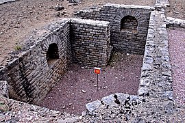
Residential and craft district
To the southeast of the forum there are foundations of terraced houses, often with porticos or atriums in front. There were also workshops of craftsmen who mainly worked metal such as copper, bronze and iron. Blacksmiths and remnants of melting furnaces can be found in the basement.
Farther away to the east there was a quarter with numerous residential buildings, the basements of which are usually so well preserved that the stone stairs leading down to them often still exist. Arched wall niches are set into some of the cellar walls, perhaps for the installation of venerable statues. The remains of underfloor heating can be found in a residential building.

Atrium of the Ucuetis Temple

The workshops' ovens (blacksmiths) have a cellar

Foundations next to workshops
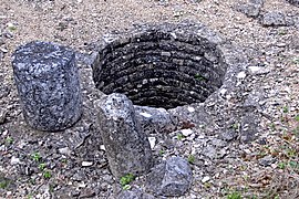
Well shaft

Terraced house foundations with porticos
House basement with arched wall niches

_unterkellert.0027.JPG)


Fall of Alesia


The Gallo-Roman settlement of Alesia with its magnificent and valuable buildings was probably inhabited and used until the end of Gaul in the 5th century. Even massive buildings deteriorate if they are not maintained. From the 9th century, the Alesia oppidum fell into disrepair. The monk Erric, who wrote down the life of St. Germanus of Auxerre in verse, reported about Alesia at the time: “ Nunc restant veteris tantum vestigia castri ” (“There are only ruins of this ancient castrum”).
Above all, the buildings became quarries, the stone material of which was relatively easy to remove and could be bricked up in new buildings without any new design. The metallurgical workshops and blacksmiths, whose services were much sought after, were largely spared of this for a long time.
At the foot of Mont Auxois, new agricultural settlements gradually developed. The largest of these settlements is today's Alise-Sainte-Reine in the southwest of Mont Auxois. The name Alise is of course reminiscent of Alesia. The name Sainte Reine (= Saint Regina ) goes back to a young martyr named Reine (= Queen), who was tortured and beheaded here at the end of the 3rd century at the age of 15.
Alesia's Church of St. Lèger , a small formerly three-aisled basilica, was built in the Merovingian and Carolingian eras (from the 7th century). Your aisles have been lost. Their arcades were walled up. The building without a tower until then received its current tower in the 12th century. The masonry of the church consists of perfectly trimmed right-angled stones, which was unusual in the country at that time. They undoubtedly come from the buildings of the Gallo-Roman Alesia. This will probably apply to most of the old houses in the near and further region.
Today's mostly meager remains of the former structures are mostly only their foundation walls and cellars, which suggests a thorough demolition of the free-standing parts of the structure down to the surface of the terrain. There are only a few buildings with towering walls, such as the enclosure wall of the theater or the masonry in the Temple of Ucuetis.
The medicinal water of Alesia, whose good reputation goes back to the Celtic times, was widely known and was used by important personalities and princely families until the 20th century.
Extent of the archaeological findings
The sources show that the excavation results currently only cover a relatively small area of the settlement and the siege technology and that the excavations will continue for several decades.
Trivia
- In his novel Caesar's Druid , Claude Cueni vividly described the siege of Alesia from the perspective of its fictional protagonist.
- The long-time unclear location of historical Alesia and the defeat at this location, which the Gauls perceived as shameful, are aptly parodied in the comic strip series Asterix . In the volume Asterix and the Arvernerschild , appropriate dialogues are put into the mouths of the Gauls ("Alesia? We don't know where this Alesia is! Nobody knows where Alesia is!").
- In the film Asterix Conquers Rome , the city's imaginary subway station can be seen briefly as part of a haunted scene. In fact, there is a train station called Alésia on the Paris Métro network .
- The folk metal band Eluveitie dedicates a song to Alesia on their concept album Helvetios , which is all about the Gallic War.
- The Canadian metal band Ex Deo also dedicates a title to the city on their album Romulus . However, this represents the view of the Romans contrary to Eluveitie.
- Alesia May 5th was a recording set of baby language recorded for test purposes at the Institute for Machine Language Processing at the University of Stuttgart .
- The Australian author Colleen McCullough describes in her novel Rubicon ( Caesar , 1997) the battle for Alesia from the point of view of both parties and keeps very close to the scientific findings when describing the processes.
Celtic and Roman coins (with Vercingetorix and Caesar)
left to right:
- Caesar was the first to be depicted on Roman coins during his lifetime.
- Vercingetorix, probably with a real portrait of Vercingetorix during his captivity in Rome
- Vercingetorix


museum

Alise-Sainte-Reine in the Département Côte-d'Or has a modern museum and exhibition center around the topic of Alesia. The MuséoParc Alésia is a three-storey building with a diameter of 52 meters, which with its cylindrical shape is supposed to symbolize the encirclement of the Gauls by the Romans .
literature
- Yann Le Bohec : Alésia. Fin août – début octobre de 52 avant J.-C. Tallandier, Paris 2012, ISBN 978-2-84734-844-6 .
- Joël Le Gall : Alésia. Archeology et histoire. Errance, Paris 1990, ISBN 2-87772-044-6 .
- Michel Reddé : Alesia. From national myth to archeology. Translated from the French by Andrej and Auguste Miron. von Zabern, Mainz 2006, ISBN 3-8053-3531-8 .
- Michel Reddé, Siegmar von Schnurbein (ed.): Alésia et la bataille du Teutoburg. Un parallèle critique des sources (= Francia . Research on Western European history. Supplements. Volume 88). Thorbecke, Ostfildern 2008, ISBN 978-3-7995-7461-7 .
- Jean-Paul Savignac: Alésia. Différence, Paris 2012, ISBN 978-2-7291-1971-3 .
- Jean-Louis Voisin: Alésia. Un village, une bataille, un site. Bourgogne, Messigny-et-Ventoux 2012, ISBN 978-2-902650-29-3 .
Web links
- The peaceful village of Alise-Sainte-Reine on the southern flank of Mont-Auxois - today and in 52 BC. Chr. Archived from the original on February 28, 2005 ; Retrieved June 14, 2005 .
Individual evidence
- ↑ Christian Goudineau: Caesar and Vercingetorix , Verlag Philipp von Zabern, Mainz 2003, p 62nd
Coordinates: 47 ° 32 ′ 14 ″ N , 4 ° 30 ′ 1 ″ E