
Vindelle
| Vindelle | ||
|---|---|---|
|
||
| region | Nouvelle-Aquitaine | |
| Department | Charente | |
| Arrondissement | Angoulême | |
| Canton | Val de Nouère | |
| Community association | Grand Angoulême | |
| Coordinates | 45 ° 43 ' N , 0 ° 7' E | |
| height | 31-125 m | |
| surface | 10.93 km 2 | |
| Residents | 1,075 (January 1, 2017) | |
| Population density | 98 inhabitants / km 2 | |
| Post Code | 16430 | |
| INSEE code | 16415 | |
| Website | http://www.vindelle.fr/ | |
 Town Hall (Mairie) of Vindelle |
||

Vindelle is a western commune with 1,075 inhabitants (at January 1, 2017) in the Charente in the region Nouvelle-Aquitaine (before 2016 Poitou-Charentes ). The municipality belongs to the arrondissement Angoulême and the canton Val de Nouère (until 2015 Hiersac ). The inhabitants are called Vindellois .
location
Vindelle is located about eight kilometers north-northwest of Angoulême in the cultural landscape of the Angoumois . The municipality is bounded by a loop of the Charente river to the north, south and east. Vindelle is surrounded by the neighboring communities of Vars in the north, Balzac in the south and east, Saint-Yrieix-sur-Charente in the south, Fléac in the south-west, Asnières-sur-Nouère in the west and Marsac in the north-west.
Population development
| year | 1962 | 1968 | 1975 | 1982 | 1990 | 1999 | 2006 | 2017 |
|---|---|---|---|---|---|---|---|---|
| Residents | 554 | 556 | 643 | 747 | 933 | 866 | 938 | 1075 |
| Sources: Cassini and INSEE | ||||||||
Attractions
- Saint-Christophe church, former priory, from the 11th / 12th centuries. Century, Monument historique since 1944
- Manor house Le Maine Joli

Saint-Christophe Church
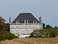
Manor house Le Maine Joli


Personalities
- Adolphe Terracher (1881–1955), Romanist