Gardes-le-Pontaroux
|
Gardes-le-Pontaroux Garda |
||
|---|---|---|
|
|
||
| region | Nouvelle-Aquitaine | |
| Department | Charente | |
| Arrondissement | Angoulême | |
| Canton | Tude-et-Lavalette | |
| Community association | Lavalette Tude Dronne | |
| Coordinates | 45 ° 31 ' N , 0 ° 18' E | |
| height | 101-220 m | |
| surface | 13.30 km 2 | |
| Residents | 275 (January 1, 2017) | |
| Population density | 21 inhabitants / km 2 | |
| Post Code | 16320 | |
| INSEE code | 16147 | |
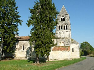
 Notre-Dame church |
||
Gardes-le-Pontaroux ( Occitan : Garda ) is a municipality with 275 inhabitants (at January 1, 2017) in the south of the western French department of Charente in the region Nouvelle-Aquitaine , close to the Perigord .
location
Gardes-le-Pontaroux lies at an altitude of about 120 meters above sea level. d. M. about 26 kilometers (driving distance) southeast of Angoulême in the old cultural landscape of the Angoumois in the Charente area . The small river Voultron flows through the municipality.
Population development
| year | 1962 | 1968 | 1975 | 1982 | 1990 | 1999 | 2006 | 2016 |
| Residents | 287 | 237 | 217 | 267 | 242 | 248 | 270 | 269 |
In the first half of the 19th century the community had almost 700 inhabitants at times; As a result of the phylloxera crisis in viticulture and the mechanization of agriculture , the number of inhabitants then fell continuously to the lows in the 1960s and 1970s.
economy
For centuries, the inhabitants of the community lived from agriculture; the soils of the municipality belong to the Bons Bois of the Cognac wine-growing region , but sales of expensive brandies have tended to decline in recent decades, so that viticulture no longer plays an important role. Income from tourism, especially the rental of holiday homes ( gîtes ), has played a not insignificant role for the municipality's income since the 1960s.
history
Significant prehistoric finds were made under the rock overhang ( abri ) of La Quina , which could be assigned to the Moustérien ( Neanderthals ) and the Aurignacians . The Roman road from Angoulême to Périgueux led through the territory of the municipality.
Attractions
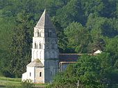
- The parish church of Notre-Dame de Gardes originally dates from the 12th century; Only the apse , which is broken polygonally on the outside but otherwise largely unadorned, and the multi-storey high crossing tower with its stone pyramid roof have survived from this period . With the addition of a side aisle on the south side, the church interior was expanded in the 15th century and provided with a Gothic ribbed vault . In addition to the Romanesque portal, the facade was given a second one in late Gothic styles; the console frieze below the unadorned gable field was extended to the south on this occasion, but the consoles are missing. A stone holy water font in the middle of the facade is unusual . In the place of the former outer wall, there are now mighty round pillars inside the church, from which the vault ribs seem to grow out. The apse and tower of the church have been recognized as a monument historique since 1943 .
- The prehistoric site of La Quina ( 45 ° 30 ′ 26 ″ N , 0 ° 17 ′ 34 ″ E ) in the Voultron Valley is fenced and therefore inaccessible, but has also been recognized as a monument historique since 1984 .
- An unusual sight is a nearby limestone cliff , which the locals called mushroom due to its unusual shape .
Web links
Individual evidence
- ↑ Église Notre-Dame de Gardes, Gardes-le-Pontaroux in the Base Mérimée of the French Ministry of Culture (French)
- ↑ Gisement de La Quina, Gardes-le-Pontaroux in the Base Mérimée of the French Ministry of Culture (French)


