
Saint-Sornin (Charente)
|
Saint-Sornin Sent Sornin |
||
|---|---|---|
|
||
| region | Nouvelle-Aquitaine | |
| Department | Charente | |
| Arrondissement | Angoulême | |
| Canton | Val de Tardoire | |
| Community association | La Rochefoucauld-Porte du Périgord | |
| Coordinates | 45 ° 42 ' N , 0 ° 26' E | |
| height | 89-242 m | |
| surface | 11.27 km 2 | |
| Residents | 801 (January 1, 2017) | |
| Population density | 71 inhabitants / km 2 | |
| Post Code | 16220 | |
| INSEE code | 16353 | |
 Town hall (Mairie) of Saint-Sornin |
||

Saint-Sornin ( Occitan : Sent Sornin ) is a municipality and a town with 801 inhabitants (as of January 1 2017) in the western French department of Charente in the region Nouvelle-Aquitaine and belongs to Arrondissement Angoulême and canton Val de Tardoire (2015 : Canton of Montbron ).
location
Saint-Sornin is located 23 kilometers east-northeast of Angoulême in the ancient cultural landscape of the Angoumois , part of the Charente . Surrounded Saint-Sornin from the neighboring communities of Marillac-le-Franc in the north, Yvrac-et-Malleyrand in the north and northeast, Orgedeuil the east, Montbron in the southeast, Vouthon in the south, Chez-Nadaud in the southwest and Moulins-sur-Tardoire with Rancogne to the west.
Population development
| year | 1962 | 1968 | 1975 | 1982 | 1990 | 1999 | 2006 | 2013 |
| Residents | 633 | 618 | 615 | 673 | 694 | 715 | 793 | 875 |
| Source: Cassini and INSEE | ||||||||
Attractions
- Saint-Saturnin church from the 12th century
- Chapel Saint-Roch (also: Chapel Notre-Dame-de-la-Lande)
- La Fenêtre Castle from the 15th / 16th centuries century

Saint-Saturnin Church
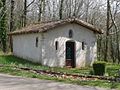
Saint Roch chapel

La Fenêtre Castle


