Touvre (Charente)
| Touvre | ||
|---|---|---|

|
|
|
| region | Nouvelle-Aquitaine | |
| Department | Charente | |
| Arrondissement | Angoulême | |
| Canton | Touvre-et-Braconne | |
| Community association | Grand Angoulême | |
| Coordinates | 45 ° 40 ′ N , 0 ° 16 ′ E | |
| height | 42-161 m | |
| surface | 9.06 km 2 | |
| Residents | 1,191 (January 1, 2017) | |
| Population density | 131 inhabitants / km 2 | |
| Post Code | 16600 | |
| INSEE code | 16385 | |
| Website | www.touvre.fr | |
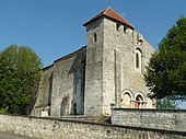
 Touvre - Sainte-Madeleine church and source lake of the Touvre |
||
Touvre is a municipality with 1191 inhabitants (at January 1, 2017) in the western French department of Charente in the region Nouvelle-Aquitaine .
location
Touvre is located about 30 meters above the karst spring of the river of the same name and only about twelve kilometers long in the old cultural landscape of the Angoumois at an altitude of about 70 meters above sea level. d. M. and about ten kilometers (driving distance) east of the city of Angoulême .
Population development
| year | 1962 | 1968 | 1975 | 1982 | 1990 | 1999 | 2006 | 2016 |
| Residents | 567 | 604 | 785 | 933 | 1020 | 1024 | 1090 | 1218 |
In the 19th century the population increased continuously from about 275 in 1800 to about 500 inhabitants in 1900. Due to the proximity to the city of Angoulême and comparatively low property prices, the population of the municipality has grown steadily in the 20th century.
economy
Agriculture still plays the most important role in the municipality's economic life. Otherwise retail, craft and smaller service companies determine the economic activity of the place.
history
Touvre is located on a trade route between Angoulême and Limoges that was already used in ancient times . Around the year 1050, Guillaume Taillefer, the bishop of Angoulême , built a castle to defend himself against the claims of his brother, Count Fulko , to defend himself . After his death, however, most of the episcopal lands fell into the hands of the counts. During the Hundred Years' War (1337-1453), the region around Angoulême was temporarily owned by the French crown. It then fell into the hands of the English, who they lost again to Marshal Louis de Sancerre in 1387. The place developed in the shadow of the castle, the existence of which is documented by its Romanesque church as early as the 12th century.
Attractions

- The parish church of Sainte-Madeleine , consecrated to St. Mary Magdalene , stands on a hill above the source lake of the Touvre in the immediate vicinity of the ruins of the old castle. It is a defensive and largely unadorned building from the 2nd half of the 12th century. The west facade of the church is determined by a three-arched triumphal arch scheme on the ground floor, with the two side arches - as usual in the region - designed as glare portals . The tower of the church with its covered viewing platform and a small weir bay ( bretèche ) above the west window underline its defensive character. The single nave interior is spanned by a brick vault added in 1845. Parts of the church building have been recognized as Monument historique since 1949 .
- The two-storey Logis de la Lèche dates from around 1700 and consists of a residential wing ( corps de logis ) with side corner pavilions; Lukarnen windows are embedded in the roof front . It is privately owned and has been recognized as a Monument historique since 1994 .
- There are several springs and streams, some of which as a washing area (in the municipality lavoir were used), as well as several former water mills , two of which continue to be used as fish farms.
Web links
Individual evidence
- ^ Église Sainte-Madeleine, Touvre in the Base Mérimée of the French Ministry of Culture (French)
- ↑ Logis de la Lèche, Touvre in the Base Mérimée of the French Ministry of Culture (French)

