Souffrignac
|
Souffrignac Sofrinhac |
||
|---|---|---|
|
|
||
| region | Nouvelle-Aquitaine | |
| Department | Charente | |
| Arrondissement | Angoulême | |
| Canton | Val de Tardoire | |
| Community association | La Rochefoucauld-Porte du Périgord | |
| Coordinates | 45 ° 36 ′ N , 0 ° 30 ′ E | |
| height | 106-178 m | |
| surface | 9.37 km 2 | |
| Residents | 134 (January 1, 2017) | |
| Population density | 14 inhabitants / km 2 | |
| Post Code | 16380 | |
| INSEE code | 16372 | |
 Souffrignac Town Hall (Mairie) |
||
Souffrignac ( Occitan : Sofrinhac ) is a French municipality with 134 inhabitants (as of January 1 2017) in the department of Charente in the region Nouvelle-Aquitaine . It belongs to the Arrondissement of Angoulême and the canton of Val de Tardoire . The responsible community association is the Communauté de communes La Rochefoucauld-Porte du Périgord . The inhabitants are called Souffrignacois or Souffrignacoises .
etymology
Souffrignac is mentioned in a document in 1321 as Sofrinhacum , other medieval forms are Soffrinhaco, Soffrinhac or Choffrignac . The place name should go back to the Gallo-Roman personal name Sufferinius or Sophronius . The suffix -acum expresses the claim to possession - Sufferiniacum thus means the property of Sufferinius .
On the Carte de Cassini of France from 1756 to 1789, the community is shown as Souffraignac .
language
Souffrignac already belongs to the Occitan language area.
location
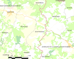
The municipality of Souffrignac is located on the Bandiat about 26 kilometers east-southeast of Angoulême and 14 kilometers northwest of Nontron . After Marthon in the West, and 5 km and after Montbron in the north nine kilometers (distance).
Souffrignac is a municipality on the border to the Dordogne department and is surrounded by the following four municipalities:
| Varaignes (Dordogne) | ||
| Feuillade |

|
Varaignes (Dordogne), Javerlhac-et-la-Chapelle-Saint-Robert (Dordogne) |
| Mainzac | Javerlhac-et-la-Chapelle-Saint-Robert (Dordogne) |
The center of Souffrignac is quite insignificant, so that some districts are significantly larger. The following hamlets and individual farms are part of the municipality: Biée , Labadias , Labétour , La Grande Forêt , La Grauge , La Ruche , Le Maine Mathely , Le Maine Santy , Le Moulin de Biée , Le Roc Noir , Les Balloteries , Les Boissières , Les Planes , Les Roffies and Pouvrière .
The lowest point in the municipality at 106 meters is on the left bank of the Bandiat on the western border with Feuillade. The highest point is at 178 meters above sea level on the northeastern edge east of the D 65. The maximum difference in altitude is 72 meters. The town center occupies a height of 140 meters on the left side of the river and thus overlooks the Bandiattal.
Transport links
The municipality of Souffrignac is on the left, not far from the main Nontron-Angoulême traffic axis (D 75). The D 65 crosses the municipality in a north-south direction and connects it with Montbron in the north and Mainzac in the south.
During the first half of the 20th century, the Quéroy-Pranzac-Thiviers railway ran directly past Souffrignac. The nearest train station was in Varaignes.
Hydrography
The municipality of Souffrignac is traversed from east to west by the Bandiat, a tributary of the Tardoire , which in turn flows into the Charente . The Bandiat coming from Nontron flows on its left side of the valley directly below the town center. When you reach the eastern municipal boundary, the Bandiattal widens - the river valley is now almost 500 meters wide - and the river begins to meander . Due to the karstification of the limestone , the Bandiat does not have any noteworthy tributaries in the municipality. However, there are smaller dry valleys on both sides. Two important arid valleys are the Grand Ruisseau du Vallon de la Tricherie , whose valley descending from the northeast just touches the municipality at its northern corner and which flows into the Bandiat on the right in the municipality of Feuillade, and the Fond de Toulenches , which extends over 150 meters crosses the plateau in the south towards the northwest and only opens into the bandiat on the left downstream from Marthon.
climate
The municipality of Souffrignac, like the west and south of the Charente department, is under oceanic influence with Aquitaine characteristics.
geology
The municipality of Souffrignac lies mostly in Bandiatgraben that of flat-lying Jura sediments of the northeastern Aquitanian basin is filled. Upcoming are the Middle Jurassic stages Bajocium , Bathonium and Callovium .
In the actual valley of Bandiats was along the north side Middle Pleistocene ocher, clay, sands with polished quartz - and plot Mountain pebbles are deposited on a central terrace (Formation Fw ). However, the river now flows in a Holocene , a good 10-meter-thick alluvial low terrace , consisting of brick-red clays with gravel-like inclusions of quartz, quartzite, jasper, granodiorite and limestone boulders (formation Fy-z ).
The river valley is framed by more than 20 meters thick Middle Bajocium (Formation j1b ) and Upper Bajocium (Formation j1c ) - white chalky, microcrystalline limestone (with oblique stratification , ooids and bioclasts ) and white, microcrystalline oolite limestone (with two ooid populations) and beige pelletoid limestone . The Bajocium can also recrystallize along the right trough shoulder of the Bandiat trench (formation jC near Biée ). The Bajocium is a very good aquifer and also tends to karstification. A cave has formed in it to the right below the town center .
On the southern plateau surface, the lower bathonium (formation j2a near Pouvrière ), upper bathonium (formation j1c-3a ) and callovium (formation j3 on the ridge near Les Planes ) follow in the hanging wall . The almost 20 meter thick lower bathon consists of brown, micro- or cryptocrystalline lithoclastic limestone, the 35 meter thick upper bathon of white and chalky cryptocrystalline, pelletoid limestone and the 25 meter thick callovium of chalky pelletoid limestone, which can contain oncolites , foraminifera and stromatolites .
The exposed, granular and biostratigraphically difficult to subdivide limestone sequence is ideally a little over 100 meters thick.
Plateau and hillside areas on both sides of the bandiat are often masked by Pleistocene loose sediments of Formation C.
history
In the Middle Ages and during the Ancien Régime, the parish of Souffrignac was dependent on La Chapelle-Saint-Robert , whose lordships often assumed the title of Lords of Souffrignac . Like a large part of Feuillade, it belonged to the Périgord . When the Charente department was established during the French Revolution , there were protests among the population.
Souffrignac and other communities in the neighborhood had not only supplied the local blacksmiths with iron ore for a long time , but also the foundry in Ruelle - before it had access to richer and cheaper ore from Lorraine due to the connection to the rail network . Cannons for the navy were cast in Ruelle.
At the beginning of the 20th century, Souffrignac's industry was represented by two very important companies. So was in BIEE a mechanized sawmill and Labétour established a file factory, the very large files for Gießwerk in Ruelle.
Population development
| Population development in Souffrignac | ||||
|---|---|---|---|---|
| year | Residents |

|
||
| 1962 | 212 | |||
| 1968 | 182 | |||
| 1975 | 141 | |||
| 1982 | 148 | |||
| 1990 | 130 | |||
| 1999 | 157 | |||
| 2006 | 130 | |||
| 2011 | 156 | |||
| 2013 | 154 | |||
| 2016 | 134 | |||
| 2017 | 134 | |||
Source: INSEE
The population of Souffrignac fell sharply in the 1960s, but has stabilized with fluctuations since 1975.
The population density is very low at 14 inhabitants / square kilometer. In the canton of Val de Tardoire, the municipality has the second lowest population figure (after Mainzac) and the third lowest population density.
mayor
Mayor of Souffrignac has been Violette Fioleau since March 2008.
Attractions
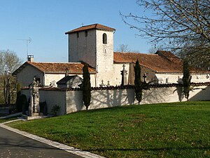
- Church Saint-Antoine from the 12th century
- Mill of Biée
- Les Jardins du Bandiat initiative with a local museum in the town center
literature
- G. Le Pochat et al. a .: Feuille Montbron . In: Carte géologique de la France at 1/50 000 . BRGM, 1986.
Web links
- Souffrignac on the annuaire-mairie.fr website
- Souffrignac on cartesfrance.fr in French
- Population development since 1793 on cassini.ehess.fr


