
Varaignes
|
Varaignes Varanha |
||
|---|---|---|

|
|
|
| region | Nouvelle-Aquitaine | |
| Department | Dordogne | |
| Arrondissement | Nontron | |
| Canton | Périgord Vert Nontronnais | |
| Community association | Périgord Nontronnais | |
| Coordinates | 45 ° 36 ' N , 0 ° 32' E | |
| height | 115-241 m | |
| surface | 16.60 km 2 | |
| Residents | 403 (January 1, 2017) | |
| Population density | 24 inhabitants / km 2 | |
| Post Code | 24360 | |
| INSEE code | 24565 | |
 Castle in Varaignes |
||

Varaignes ( Occitan Varanha ) is a French municipality with 403 inhabitants (at January 1, 2017) in the department of Dordogne in the region Nouvelle-Aquitaine . It belongs to the Arrondissement of Nontron and the canton of Périgord Vert Nontronnais (until 2014: Bussière-Badil ). The responsible community association is the Communauté de communes du Périgord Nontronnais . The inhabitants are known as Varaignauds or Varaignaudes .
etymology
The place name goes back very likely to the Gallo-Roman proper name Varanius or Veranius .
geography
Varaignes is a border municipality to the Charente department and is four kilometers northwest of Javerlhac and 16 kilometers northwest of Nontron . It is surrounded by the following seven neighboring communities:
| Montbron (Charente) | Eymouthiers (Charente) | Soudat |
| Souffrignac (Charente), Feuillade (Charente) |
.svg)
|
Teyjat |
| Javerlhac-et-la-Chapelle-Saint-Robert |
The municipal area includes the following hamlets, individual farms, mills and landmarks: Beauséjour, Bellevue, Chablat, Chante-Grelette, Chez Berthonnet, Chez Bouret, Chez Chèvre, Chez Durand, Chez Gauty, Chez Guillout, Chez Marot, Chez Mondy, Chez Raby, Chez Rouyer, Croix de la Plat, Fontaine de Sainte-Marguerite, La Basse Côte, La Baysse, La Côte, La Croix des Épingles, La Vacherie, Le Cousset, Le Débat, Le Fayard, Le Gauty, Le Grand Moulin, Le Moulin de Varaignes, Le Pavillon, Le Petit Cousset, Le Puy de Belet, Les Bauches (twice), Les Faures, Les Laquoux, Les Loges, Les Penauds, Les Peyrières, Les Virades, Montchoisy, Petit Paris, Pommaré, Quillac and Versailles .
The topographically lowest point of the municipality is 115 meters above sea level on the Bandiat on the western border with Souffrignac, the highest point at 241 meters above sea level on the D 163 in the far north. The maximum height difference is 126 meters. The center is at 142 meters above sea level.
Transport links

The center of Varaignes is located on the right, not far from the main traffic axis Nontron- Angoulême (D 75) and can be reached from there via the D 90, which also connects it to the Montbron - Piégut-Pluviers (D 5 in Charente or D 91 in the Dordogne) further to the north. The D 92 from La-Chapelle-Saint-Robert in the direction of Piégut-Pluviers crosses the D 75 and then runs through the southeast of the municipality. The D 163 is passing on the northwest boundary (border with the Charente) that Feuillade about Eymouthiers with Écuras connects.
The Quéroy-Pranzac-Thiviers railway once ran through Varaignes . The associated train station was at Le Grand Moulin .
Long-distance hiking trail
From Feuillade crossing distance footpath GR de Pays Entre Angoumois et Périgord ( between Angoumois and Périgord ) to the northwest of the municipality towards Eymouthiers.
Hydrography

The Ruisseau de Varaignes of the same name flows through the village - a right branch of the bandiats. The north-west of the municipality runs through the dry valley of the Grand Ravin du Vallon de la Tricherie , which flows into the Bandiat on the right near Feuillade . Both valley systems are oriented to the southwest. Due to karstification phenomena in the calcareous Jura sediments , the side valleys of the Grand Ravin - especially its large, west-northwest facing side valley at Chante-Grelette - and the Ruissseau de Varaignes are also dry valleys.
geology
The community is underlain in its entirety by flat sedimentary rocks . The sequence belongs to the northeastern Aquitaine Basin , whose sediments in the Lias (for example further east near Soudat ) transgressed over the Variscan basement of the Massif Central . The main thing is Dogger .
The sequence begins with white, chalk-like oolite limestone from the Middle Bajocian - Formation j1b . This is followed by the Upper Bajocian (white oolite limestone and beige peloid-bearing limestone of the j1c formation ) and Lower Bathonian (brown, lithoclast- rich limestone micrite of the j2a formation ). The Bajocium is a very good aquifer and also tends to karstification .
On the north-western edge of the municipality, an elongated tertiary fluvial rubble fan pulls out of the basement and lies over colluvium and sedimentary rocks; it consists of sand and gravel and forms topographical ridges (formation HF ).
Plateau and slope areas are largely masked by colluvial Pleistocene loose sediments (formations HC and C ).
In the valley of Bandiats were right side Middle Pleistocene ocher, clayey sands, with polished quartz - deposited and plot Mountain pebbles on a central terrace (Formation Fw ). The valleys of Bandiat, Ruisseau de Varaignes and Grand Ravin are filled with Holocene alluvium ( Fy-z formation ).
Shortly before entering the town, a southeast-northwest trending fault zone traverses , which runs parallel to the Javerlhac fault zone with an offset of 150 meters to the northeast and possibly persists as far as Vouthon . The basement block on the northeast side was lifted out from here. It shows the same mineralization with cadmium- containing zinc and lead ( sphalerite with greenockite and galena ). The disturbance is likely to be part of the terrain expression on the right shoulder of the trough in the Bandiat trench . Smaller transverse fractures strike in a northeasterly direction, more or less parallel to the right side valleys of the Bandiat. Along their course, the Jurassic limestones underwent a very significant recrystallization (formation jC ).
Up until 1860, iron ore was extracted from the tertiary overburden of the Sidérolithique near La Côte - comparable to the neighboring communities of Souffrignac, Soudat, Teyjat and Javerlhac .
ecology

Natural park
The municipality of Varaignes is an integral part of the Périgord-Limousin Regional Natural Park .
Protected areas
Under conservation , the Talungen of Bandiats and its right tributary are Ruisseau de Varaignes . These areas are designated as ZNIEFF (French zone naturelle d'intérêt écologique, faunistique et floristique ) of type 1 under the name Vallées du réseau hydrographique du Bandiat . Its flora consists of more than 100 plant species with large ormennig ( Agrimonia procera ) and Atlantic hare bells ( Hyacinthoides non-scripta ) as indicator plants.
history
.JPG)
The traces of human settlement in Varaignes can be traced back to the Paleolithic (finds near Les Roches ). Evidence was also found for the Gallo-Roman culture . The Saint-Jean Baptiste church dates from the 12th and 13th centuries (with Romanesque choir, Romanesque portal in the Limousin style and Gothic side chapels). The construction of the Varaignes Castle also began in the 13th century and was heavily rebuilt in the 16th century. It has a tower ( donjon ), battlements, underground cellar vaults and an entrance portal in the Renaissance style .
Population development
| Population development in Varaignes | ||||
|---|---|---|---|---|
| year | Residents |

|
||
| 1962 | 516 | |||
| 1968 | 457 | |||
| 1975 | 436 | |||
| 1982 | 436 | |||
| 1990 | 432 | |||
| 1999 | 418 | |||
| 2004 | 415 | |||
| 2005 | 408 | |||
| 2009 | 424 | |||
| 2014 | 414 | |||
| 2016 | 418 | |||
| 2017 | 403 | |||
Source: INSEE
.JPG)
The population figures are generally declining, they had a sharp decline after 1962, but which has flattened out since 1975.
With an area of 16.60 square kilometers, the municipality of Varaignes has a population density of 24 inhabitants / km².
mayor
Mayor of Varaignes has been the non-party Ghislaine de Moël since March 2001.
Attractions
- Church Saint-Jean Baptiste from 12-13. Century. Structurally, it underwent major changes in the 15th and 19th centuries.
- Varaignes Castle from the 13th and 16th centuries. It houses a workshop and museum of weaving and the local slipper industry (Charentaises) .
Events
Every year on November 11th a popular turkey market takes place in Varaignes . On this occasion the two brotherhoods from Varaignes and Licques in northern France meet .
Photo gallery
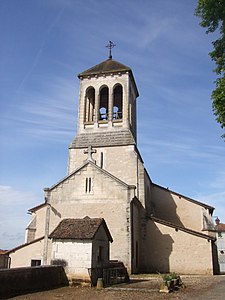 The Saint-Jean-Baptiste church
 A church window
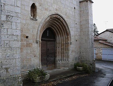 The entrance portal
 the pulpit
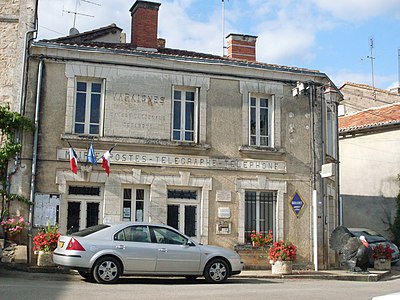 Mairie and Post
 Castle entrance with tower
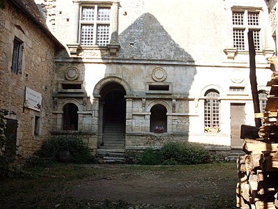 Castle courtyard
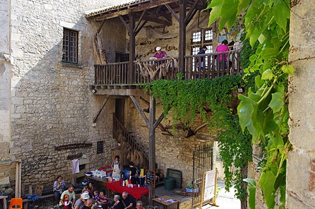 Inner courtyard of the museum
 Industrial loom in the museum
 The Ruisseau de Varaignes

.JPG)

.JPG)


.JPG)
Individual evidence
- ↑ Occitan names of the parishes in Périgord on the website of the Conseil général de la Dordogne
- ↑ Varaignes on the Insee website
swell
- G. Le Pochat and others: Feuille Montbron . In: Carte géologique de la France at 1/50 000 . BRGM, 1986.
- Dominique Richard (Ed.): Le Guide Dordogne-Périgord . Fanlac, Périgueux 1993, ISBN 2-86577-162-8 .