
Milhac-de-Nontron
| Milhac-de-Nontron | ||
|---|---|---|
|
||
| region | Nouvelle-Aquitaine | |
| Department | Dordogne | |
| Arrondissement | Nontron | |
| Canton | Périgord Vert Nontronnais | |
| Community association | Périgord Nontronnais | |
| Coordinates | 45 ° 28 ' N , 0 ° 47' E | |
| height | 151-331 m | |
| surface | 34.75 km 2 | |
| Residents | 505 (January 1, 2017) | |
| Population density | 15 inhabitants / km 2 | |
| Post Code | 24470 | |
| INSEE code | 24271 | |
.JPG) Fortified church of Saint-Martin in Milhac-de-Nontron |
||

Milhac-de-Nontron , Occitan Milhac de Nontronh , is a commune with 505 inhabitants (at January 1, 2017) of the North department Dordogne in the region Nouvelle-Aquitaine (before 2016 Aquitaine ). It belongs to the Arrondissement of Nontron and the canton of Périgord Vert Nontronnais ( Saint-Pardoux-la-Rivière until 2015 ). The responsible community association is the Communauté de communes du Périgord Nontronnais . The inhabitants are called Milhacois or Milhacoises .
etymology
The name Milhac is derived from the Gallo-Roman proper name Emelius - in turn derived from the Latin Aemelius - provided with the suffix –acum ( Aemeliacum ), which functions as a place or title ( Gut des Aemelius ).
Since several Milhacs exist, de Nontron was added for further specification - Nontron is the next largest city and sub-prefecture .
geography
Milhac-de-Nontron is halfway between Nontron and Thiviers , just under 12 kilometers (as the crow flies) from both cities. After Saint-Pardoux-la-Rivière in the northwest, it is 4 kilometers (also as the crow flies).
The municipality is surrounded by the following five neighboring municipalities:
| Saint-Pardoux-la-Rivière | Saint-Saud-Lacoussière | |
| Saint-Front-la-Rivière |
.svg)
|
|
| Villars | Saint-Martin-de-Fressengeas |
The very large municipal area of Milhac-de-Nontron - in terms of area the second largest municipality in the canton of Périgord Vert Nontronnais after Saint-Saud-Lacoussière - includes numerous hamlets, farms, mills, mansions and landmarks in addition to the town center:
Au Petit Bos , Aux Boueygues , Belle Combe , Bois de Vitrac , Bordessoule , Chantres , Chez Billat , Coudert Ferry , Croze , Fontaine de Cardissou , Fousseyraud , Grosse Motte , La Bierge , La Coutille , La Fouillarge , La Gare , La Garelie , La Glaudie , La Grange , La Grelière , La Lande (twice), La Marthonie , La Mothe , La Privadie , La Robinie , La Roussarie , Labat , Lajaunie , Lamidet , Le Chadeuil , Le Chatenet , Le Chaudeau , Le Jord , Le Moulin de Chantres , Le Moulin de Panit , Le Moulin de Piogeat , Le Petit Moulin , Le Saudet , Le Soulier , Le Taravaud , Les Boissières , Les Combes , Les Fayes , Les Garroux , Les Grandes Terres , Les Jarisses , Les Landes de Pauthiers , Les Moulières , Les Vignes , Magnac , Maimbot , Mathaly , Maumont , Mazeroux , Mortegoutte , Négretterie , Panit , Peyrelevade , Piogeat , Planche Famy and Puyriol .
The topographically lowest point of the municipality is 151 meters above sea level on the Ruisseau de Chantres in the northwest, on the border with Saint-Pardoux-la-Rivière; the highest point at 331 meters is on the northeast corner. The maximum height difference is 180 meters. The town center is at 179 meters above sea level.
Transport links

The center of Milhac-de-Nontron is crossed by the D 707 from Saint-Pardoux-la-Rivière to Saint-Jean-de-Côle and Thiviers in a south-easterly direction. The town center is also crossed by the D 82 E 1 coming from the northeast, which continues to Villars. The D 82 from Saint-Saud-Lacoussière to Villars runs through the municipality about 1.5 kilometers east of the town center in a south-south-west direction. The extreme north touches the D 83 E, a junction of the D 82 to Saint-Pardoux-la-Rivière. A municipal road connects the town center with Saint-Front-la-Rivière.
Milhac-de-Nontron once owned a train station on the Quéroy-Pranzac-Thiviers railway line, which has now been closed . The route is now a popular cycling and hiking trail.
Long-distance hiking trail
The eastern border of the municipality of Milhac-de-Nontron is touched by the long-distance hiking trail GR 654 from Châlus to Périgueux (meanwhile GR 361).
Hydrography
The town center is traversed in a south-westerly direction by the Trincou , a right branch of the Côle . The eastern part of the municipality is drained by the Ruisseau de l'Étang Rompu , which also drains to the southwest and then flows into the Trincou at Villars. The Ruisseau de Chantres initially drains the north of the municipality in a north-east-south-west direction, but turns west as it leaves the basement and flows into the Dronne on the left in Saint-Pardoux-la-Rivière .
geology

The municipal area of Milhac-de-Nontron is divided into two very different areas due to the marginal fault of the northwestern Massif Central : the area in the northeast belongs to the metamorphic , Variscan basement , whereas the southwest sector represents the edge of the northeast Aquitaine basin . The marginal fault is also noticeable topographically, for example the basement was raised against the basin sediments.
The basement consists mainly of neoproterozoic mica schists of the parautochthonous mica schist unit ( ξ 1 ). At Lajaunie in the north, a small deposit of Saint-Mathieu leukogranite ( γ 2 b-m ) has been preserved in the mica schists. The mica schists usually belong to the staurolite zone , but can also reach the thistle zone at Chantres . They usually strike northwest, dipping northeast at 17 to 45 degrees. Recognizable linear lines point flat to the southeast.
The flat sediments set in transgressively in the lias . The lower exposed strata are sandstones and conglomerates of the Lower Hettangian (formation l1 west of Les Moulières ). This is followed by dolomites , dolomitic marls and fine-grained sandstones from the Upper Hettangian (formation l2 ). This layer element is also found on the basement beyond the marginal fault (s) and is then heavily silicified . The next higher layer member are limestone and partly dolomitic oolite limestone of the Sinemurian (formation 13-4 ), which can also be silicified. The lias closes with clay stones from the Toarcium (formation 17-9 ), the Pliensbachium is missing. The Lias is overlaid by the Dogger , usually oolite and cryptocrystalline limestone of the Upper Bajoc (formations j1b and j1c-2a ) and the bathonium (formation j2b ). At Milhac , the Dogger has recrystallized . To the south and west of the town center, the chalky limestone layers of the Cenomanium transgress over the Bathonium (formation c1-2 ). At the southern border one can also see overlying Ligérien (formation c3a ) and Lower Angoumien (formation c3b ).
The marginal fault is bordered by (probably) Eocene Sidérolithique - red, clayey, iron-rich sands of the formation ep . Slopes are often masked by Pleistocene alluvium ( river gravel of the Fs formation and the resulting colluvium ( CF ' formation )). The mica schists of the basement in the northeast are largely covered by colluvium of the AC formation , which probably originates from the Würm glacial period . South of La Marthonie lies limestone debris from the Würm glacial period (formation GP ). The valleys of the Trincou and the Ruisseau de l'Étang Rompu , widening southwest of the marginal fault, are filled with alluvium from the Worm Period to the Holocene (Formation K ).
The edge fault makes a significant change of direction north of the town center from northwest to north-northwest. It is accompanied by several secondary faults towards the basin, which often run parallel to these two directions, but can also be oriented north-north-east, north-east and east-north-east. At Chantres in the north, the marginal fault splits into numerous Riedel fractures, which indicate an additional side-shifting character. At the same time, consolidated alluvium (up to 30 meters thick sands and gravels) of the HF formation appears here , which contains up to 30 centimeters large basement pebbles and is regarded as the Eocene / Pliocene .
The following mineralization should be mentioned: barite at the base of silicified Lias limestone near Maumont , as well as manganese , also near Maumont . In Sidérolithique contained kaolin for porcelain production was once at Croze dismantled.
ecology
.jpg)
Natural park
The municipality of Milhac-de-Nontron has been an integral part of the Périgord-Limousin Regional Nature Park since 1998 .
Protected area
The catchment area of the Ruisseau de Chantres (as part of the Dronne upper reaches) in the north of the municipality of Milhac-de-Nontron has been placed under Natura 2000 protection.
history
The traces of human presence in Milhac-de-Nontron go back at least to the Neolithic (finds near Piogeat , excavations near Tabanou ). Remains of the megalithic culture have also been preserved ( menhirs and a tumulus near Coudert Ferry ). The Romanesque chapel in Chantres dates from the 12th century, the only remnant of the former Cistercian priory of Saint-Blaise, which belonged to the Dalon monastery . The fortified church of Saint-Martin in the center of Milhac was under the Knights Templar . Another chapel from the 12th century has been preserved, which can be seen at the La Glaudie manor from the 15th century. The entrance portal from the manor house in Milhac dates back to the 16th century. The Magnac manor was built in the 16th and 17th centuries, that of Le Taravaud in the 17th century.
Population development
| Population development in Milhac-de-Nontron | ||||
|---|---|---|---|---|
| year | Residents |

|
||
| 1962 | 800 | |||
| 1968 | 740 | |||
| 1975 | 702 | |||
| 1982 | 636 | |||
| 1990 | 573 | |||
| 1999 | 611 | |||
| 2006 | 603 | |||
| 2007 | 602 | |||
| 2008 | 601 | |||
| 2013 | 541 | |||
| 2015 | 526 | |||
| 2017 | 505 | |||
Source: INSEE
The population in Milhac-de-Nontron was steadily declining until 1990, but has since stabilized somewhat, only to decrease again from 2008 onwards.
With an area of 34.75 square kilometers, the population density is 15 inhabitants / km².
mayor
Mayor of Milhac-de-Nontron has been the non-party Pascal Mechineau since April 2014.
Economy
.JPG)
employment
In 2012, the working age population aged 15 to 64 in Milhac-de-Nontron was 175; this corresponds to 35.1% of the total population. The number of unemployed rose from 18 in 2007 to 23, the unemployment rate is now 11.6%.
Companies
On December 31, 2013, 63 companies were located in the municipality, of which 34 were in the trade, transport or services sector, 16 in agriculture, forestry and fishing, 7 in construction, 4 in industry and 2 in the administration, teaching, health or social sectors .
Attractions
- Chantres Romanesque chapel from the 12th century
- Fortified church of Saint-Martin in Milhac with a nave from the 14th century
- Manor La Glaudie from the 15th century
- 16th century manor house in Milhac
- Magnac manor from the 16th century
- 17th century mansion of Le Taravaud
- A 19th century building near Fousseyraud , a historic monument since 1974
Photo gallery
 Mairie
 Fousseyraud
 Entrance portal of Saint-Martin
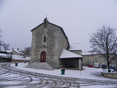 Saint Martin in winter
 Saint Martin
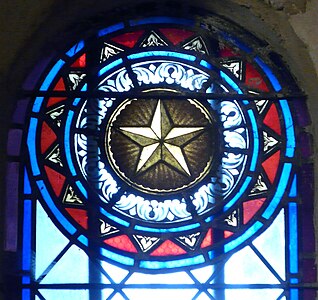 Leaded glass window in the Templar Church
 Fountain square in front of the Mairie


.JPG)

literature
- P.-L. Guillot and others: Feuille Thiviers . In: Carte géologique de la France à 1/50000 . BRGM, ISBN 2-7159-1810-0 .
- Dominique Richard (Ed.): Le Guide Dordogne-Périgord. Fanlac, Périgueux 1993, ISBN 2-86577-162-8 .
Individual evidence
- ^ Thierry Hourlier: Les églises fortifiées de Dordogne . Éditions Patrimoines Médias, 1997, ISBN 2-910137-20-1 , p. 25 .
- ↑ Milhac-de-Nontron on the Insee website