Trincou
| Trincou | ||
|
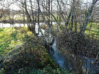
View from Condat on the Trincou valley |
||
| Data | ||
| Water code | FR : P7080500 | |
| location | France , Nouvelle-Aquitaine region | |
| River system | Dordogne | |
| Drain over | Côle → Dronne → Isle → Dordogne → Atlantic Ocean | |
| source | in the municipality of Milhac-de-Nontron 45 ° 29 ′ 6 ″ N , 0 ° 48 ′ 4 ″ E |
|
| Source height | approx. 285 m | |
| muzzle | in the municipality of Condat-sur-Trincou in the Côle coordinates: 45 ° 22 ′ 9 ″ N , 0 ° 41 ′ 56 ″ E 45 ° 22 ′ 9 ″ N , 0 ° 41 ′ 56 ″ E |
|
| Mouth height | 110 m | |
| Height difference | approx. 175 m | |
| Bottom slope | approx. 10 ‰ | |
| length | 17 km | |
| Left tributaries | Ruisseau de l'Étang rompu | |
|
The mouth of the Trincou into the Côle (seen above) |
||
The Trincou is a small river in southwest France (north of the Dordogne department ). After 17 kilometers it flows into the Côle as a right tributary . Its average gradient is 10.54 m / km.
Flow through communities
- In the canton of Saint-Pardoux-la-Rivière :
- In the canton of Champagnac-de-Belair :
geography
The Trincou rises at a height of about 285 meters near the hamlet of La Garde in the municipality of Milhac-de-Nontron, about 3 kilometers northeast of the town center. Its upper course is dammed into several small ponds. Beyond Milhac , his course gradually turns in a south-south-westerly direction. Shortly before Villars it takes up the Ruisseau de l'Étang rompu as a left side stream . There is then another change of course to the southwest. The Trincou then flows below Condat-sur-Trincou and after another 1.5 kilometers flows into the Côle on the right at the hamlet of Valade (border with the municipality of Brantôme ) at an altitude of 110 meters .
geology
The Trincou rises in the metamorphic basement of the northwestern Massif Central , more precisely in mica schists of the parautochthonous mica schist unit , which, however, are partially covered by alterites of the Pleistocene colluvium . About 1.5 kilometers before Milhac the river crosses the marginal fault of the Massif Central and then meets flat sediments of the northeastern Aquitaine Basin - first silicified Hettangian , briefly also Sidérolithique of the Eocene , then Dogger recrystallized in the vicinity of Milhac . In its further course in the direction of Villars, the Trincou Bathonium and then transgressive Upper Chalk layers ( Cenomanium ) runs through . Shortly before Villars, layers of the Turonium ( Ligérien ) are on the right-hand side for the first time . Villars itself is built on a slightly raised cenomanium due to disturbances. About 1.5 kilometers before Condat , after crossing further Turoniums, Coniacium finally follows . Another fault zone runs at Condat , the southeastern extension of the Mareuil anticline . The southwest block has been raised so that the river ends its journey in layers of the Turonian ( Angoumia ).
Hydrology
The edge fault of the Massif Central near Milhac-de-Nontron can be seen as a clear breakpoint on a height profile of the Trincou . In the steeper upper reaches the more resistant basement rocks, on the other hand in the sediments the profile flattens out noticeably.
history
The oldest traces of settlement in or in the immediate vicinity of the Trincou valley go back at least to Magdalenian (cave paintings in the caves of Villars ). A dolmen and a menhir date from the megalithic period and can be seen at Fouret , Condat-sur-Trincou. The village churches of Condat , Milhac and Villars were built in the early Middle Ages .
Landmarks on the river
- The Church of Milhac-de-Nontron.
- A 19th century building near Fousseyraud , Monument historique , Milhac-de-Nontron parish.
- Manor in Le Taravaud from the 17th century , community Milhac-de-Nontron.
- The church of Villars.
- The caves of Villars, a little out of the way in the valley of the Ruisseau de l'Étang rompu .
- The Romanesque church of Condat-sur-Trincou.
- Castle of Condat-sur-Trincou from the 13th century .
- Menhir and dolmen at Fouret , Condat-sur-Trincou municipality.
Remarks
- ↑ a b geoportail.fr (1: 16,000)
- ↑ a b The information on the length of the river is based on the information about the Trincou at SANDRE (French), accessed on March 8, 2011, rounded to full kilometers.
literature
- Floc'h, J.-P .: Feuille Nontron . In: Carte géologique de la France at 1/50 000 . BRGM.
- Guillot, P.-L. et al .: Feuille Thiviers . In: Carte géologique de la France at 1/50 000 . BRGM.


