
Drone
| Drone | ||
 The Dronne on the rapids of the Saut du Chalard near Champs-Romain |
||
| Data | ||
| Water code | FR : P7-0250 | |
| location | France , Nouvelle-Aquitaine region | |
| River system | Dordogne | |
| Drain over | Isle → Dordogne → Atlantic Ocean | |
| source | in the municipality of Bussière-Galant 45 ° 38 ′ 54 ″ N , 1 ° 4 ′ 50 ″ E |
|
| Source height | approx. 486 m | |
| muzzle | in the municipality of Coutras in the Isle of Coordinates: 45 ° 2 ′ 16 ″ N , 0 ° 8 ′ 54 ″ W 45 ° 2 ′ 16 ″ N , 0 ° 8 ′ 54 ″ W |
|
| Mouth height | approx. 4 m | |
| Height difference | approx. 482 m | |
| Bottom slope | approx. 2.4 ‰ | |
| length | 201 km | |
| Catchment area | 2816 km² | |
| Outflow at the Coutras gauge |
MQ |
25.3 m³ / s |
| Left tributaries | Côle , Rizonne , Chalaure | |
| Right tributaries | Boulou , Lizonne , Tude | |
| Small towns | Coutras | |
The Dronne , in Occitan Drona , is a river in southwest France that runs in the Nouvelle-Aquitaine region . It rises in the Périgord-Limousin Regional Nature Park , in the municipality of Bussière-Galant , generally drains in a south-westerly direction and flows 201 kilometers into the municipality of Coutras as a right tributary into the Isle . On its way, the Dronne crosses the Haute-Vienne , Dordogne , Charente , Charente-Maritime and Gironde departments .
Places on the river
- Bussière-Galant
- Saint-Pardoux-la-Rivière
- Champagnac-de-Belair
- Brantôme
- Bourdeilles
- Lisle
- Tocane-Saint-Apre
- Ribérac
- Saint-Aulaye
- La Roche-Chalais
- Aubeterre-sur-Dronne
- Saint-Aigulin
- Les Églisottes-et-Chalaures
- Les peintures
- Coutras
Hydrology
Their mean gradient is 2.50 m / km. The following figure shows the annual distribution of the average monthly discharge Q in m 3 / s, measured at Coutras (mean value over 38 years):

The annual average value of the drone is 25.3 m 3 / s. The Dronne is strongly influenced by the seasons. In winter (December to the end of April) the monthly discharge is between 34 and 51.9 m 3 / s with peaks in January and especially in February. In the summer between July and September the discharge drops drastically to 4.83 m 3 / s in August.
geology
The Dronne rises in the Variscan basement of the Massif Central , its source is in the extreme south of the granite massif of Nexon-Les Cars . It flows in a southerly direction only briefly through the paragneiss of the upper gneiss cover , then changes direction to west-southwest and crosses the rocks of the lower gneiss cover (paragneiss and eye gneiss ). It then meets the mica slate of the parautochthonous mica slate unit , the structurally deepest unit in the Massif Central. After another change of direction to the south-south-west and south-west, it crosses the Saint-Saud-Leukogranit in a narrow and relatively indented valley with rapids and then the paragneiss of the Dronne group . Shortly above Saint-Pardoux-la-Rivière, it leaves the basement in a south-south-westerly direction, its valley widens and from now on it flows to its mouth in the flat, Mesozoic sedimentary rocks of the Aquitaine Basin ( Jura , Upper Cretaceous and Paleogene ). Shortly before Brantôme, the Dronne meets the more resistant Turonium and Coniacium , the valley narrows again and the river winds its way southwest in numerous loops surrounded by steep walls. At Lisle, the Dronne then encounters the softer formations of the Santonium and Campanium , which it traverses in a broad valley in a westerly direction towards Aubeterre. South of Chalais there is a final change of direction to the southwest with the Eocene and Oligocene sands as the last obstacle.
Alluvial terraces show that the river has lowered its course by up to 100 meters since the Lower Pleistocene . In the wide valley areas, a former meander has even been preserved - the river consequently took up the open space available to it. The river narrowing behind Brantôme, however, he followed since the beginning of the Pleistocene. In the steep walls, various stages in the subsidence of the river can be seen beautifully as scouring.
ecology
The Dronnetal has very diverse biotopes with a very rich fauna and flora. For this reason, 80% of the river's course is either Natura 2000 protected areas or FFH areas .
The following Natura 2000 protected areas are designated:
- From the source to Saint-Pardoux-la-Rivière . In this section the Dronne crosses heathland, wet meadows, fields and forests.
Several endangered species are found here: freshwater pearl mussel ( Margaritifera margaritifera ), yellow-bellied toad ( Bombina variegata ), helmet-Azurjungfer ( Coenagrion mercuriale ), Marsh Fritillary ( Euphydryas aurinia ), clawed crayfish ( Austropotamobius pallipes ), and several mammals such as the otter ( Lutra lutra ) and three species of bat . Among the fish the bullhead ( Cottus gobio ) and the brook lamprey ( Lampetra planeri ).
- South of Brantôme to the estuary. The Dronne flows here for 110 kilometers through wet meadows, arable land and bocage . This area is particularly important for the reproduction of the sea lamprey ( Petromyzon marinus ). It is home to five other threatened fish species, the jackdaw crab and the European mink ( Mustela lutreola ).
- The right-hand slopes in the municipal areas around Bourdeilles , Grand-Brassac and Montagrier . They consist of steppe and heathland, an ideal location for numerous orchid species and the common juniper ( Juniperus communis ).
There are also seven other FFH areas that largely overlap with the above-mentioned protected areas, including:
- A 25 kilometer long and 541 hectare stretch of river between Mialet and Saint-Pardoux-la-Rivière. In wooded gorges, Mediterranean and Atlantic flora alternate depending on the location.
- A 4-kilometer stretch of river near Saint-Front-la-Rivière . Wet meadow flora and a very interesting flora adapted to the surrounding limestone walls.
- Between Brantôme and Lisle . The Dronne meanders through forest areas and wet meadows for 18 kilometers. Its course is lined by limestone walls, the south sides of which have a Mediterranean flora, but the north sides a mountain flora.
Photo gallery

Saint-Pierre Abbey in Brantôme
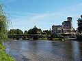
Bridge at Bourdeilles with lock
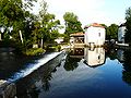
Moulin du Pont mill near Montagrier

The drone at Coutras

The Dronne at Aubeterre-sur-Dronne


.JPG)


- Platel, J.-P., Célérier, G., Duchadeau-Kervazo, C., Chigot, D. and Charnet, F. (1989). Carte géologique de la France à 1/50000. Feuille Périgueux (Ouest). Editions du BRGM.
Web links
Individual evidence
- ↑ a b geoportail.fr (1: 16,000)
- ↑ a b The information on the length of the river is based on the information about the Dronne at SANDRE (French), accessed on March 27, 2011, rounded to full kilometers.
- ↑ a b hydro.eaufrance.fr (Station: P8462510 , option: Synthèse )