Saint-Front-la-Rivière
|
Saint-Front-la-Rivière Sent Front la Ribiera |
||
|---|---|---|
|
|
||
| region | Nouvelle-Aquitaine | |
| Department | Dordogne | |
| Arrondissement | Nontron | |
| Canton | Périgord Vert Nontronnais | |
| Community association | Périgord Nontronnais | |
| Coordinates | 45 ° 28 ′ N , 0 ° 44 ′ E | |
| height | 125-233 m | |
| surface | 17.89 km 2 | |
| Residents | 518 (January 1, 2017) | |
| Population density | 29 inhabitants / km 2 | |
| Post Code | 24300 | |
| INSEE code | 24410 | |
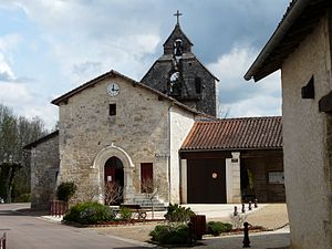
 Saint-Front church |
||
Saint-Front-la-Rivière ( Occitan Sent Front la Ribiera ) is a commune with 518 inhabitants (at January 1, 2017) of the North department Dordogne in the region Nouvelle-Aquitaine . It belongs to the Arrondissement of Nontron and the canton of Périgord Vert Nontronnais (until 2014: Saint-Pardoux-la-Rivière ). The responsible community association is the Communauté de communes du Périgord Nontronnais . The inhabitants are known as Saint-Frontais or Saint-Frontaises .
etymology
The Occitan name Sent Front la Ribiera is derived from the Holy Fronto (Sanctus Fronto) and from la ribiera with the meaning of the river , meaning the Dronne .
geography
Saint-Front-la-Rivière is located five kilometers south-southwest of Saint-Pardoux-la-Rivière , eight kilometers southeast of Nontron and 14 kilometers north-northeast of Brantôme .
The municipality is surrounded by the following five neighboring municipalities:
| Sceau-Saint-Angel | Saint-Pardoux-la-Rivière | Milhac-de-Nontron |
| Sceau-Saint-Angel |

|
Milhac-de-Nontron |
| Quinsac | Quinsac | Villars |
In addition to the town center, the municipality of Saint-Front-la-Rivière includes the following hamlets, farms, mills, castles and landmarks:
Babayou , Bélêterie , Bois de Mousseau , Bouteiller , Chabrellac , Chante-Perdrix , Château de la Rénaudie , Château Gaillard , Chazelle , Curegousset , Fontaine de la Peur , Jauviderie , L'Étang , La Garenne , La Pépide , La Peycelière , La Rebière , La Varenne , La Vigerie , Labrousse , Le Caneau , Le Grand Trou , Le Lac Blanc , Le Moulin de Pombol , Le Moulin Turelet , Le Pommier , Le Sablon , Les Bertades , Les Brames , Les Devalantes , Les Réserves , Lusson , Maison Neuve , Malcontent , Milan , Montrabet , Peycelière , Piche Chabre , Pombol , Puychabrol , Soulage and Terre du Prêtre .
The topographically lowest point of the municipality is at 125 meters above sea level on the Dronne in the extreme south, the highest point at 233 meters on the southwest corner near Malcontent . The maximum height difference is 108 meters. The town center is at 132 meters above sea level.
Transport links
The center of Saint-Front-la-Rivière is located on the D 83 from Brantôme to Saint-Pardoux-la-Rivière. It is also crossed by a municipal road in an east-west direction, which leads from Milhac-de-Nontron to Sceau-Saint-Angel. The D 3 runs through the southern part of the municipality from Nontron to Villars. Parallel to the D 83, which runs along the left side of the Dronne valley, a municipal road connects the hamlets on the right side of the Dronne.
Hydrography
The municipality of Saint-Front-la-Rivière is traversed by the Dronne in a north-north-east-south-south-west direction approximately in the middle. The floodplain, in which the Dronne meanders , is over 500 meters wide. Several smaller left and right side valleys reach the river, but all of them are designed as dry valleys due to the calcium topography . Only in the last right side valley on the southern border, which is fed by a spring , does water actually flow. A source with no outflow near Curegousset in the south-west is the Fontaine de la Peur .
geology
The municipality of Saint-Front-la-Rivière is made up entirely of flat-lying sediments from the north-eastern Aquitaine Basin , mainly Dogger and Upper Cretaceous and their continental deck sediments from the Tertiary .
The oldest open formation is the Lower Bathonium of the j 1c-2a formation ( oolite limestone , to be seen on the left and right northern edge of the valley of the Dronne to a little south of the town center). Above it lie cryptocrystalline fossil limestone (formation j 2b - Unterbathon, up to the north of Chazelle , around Le Caneau and near Le Sablon ) and bioclastic limestone (formation j 2-6a - Oberbathon near Jauviderie and La Pépide ).
Cenomanium of the formation c 1-2 transgressed over the Dogger (the sandy, alveoline- bearing limestones are exposed in smaller deposits to the left of the Dronne near Le Caneau and Le Sablon and to the right of the Dronne near L'Étang , Soulage and Milan ). The Cenomanium is replaced by layers of the Turonian (chalky tuber limestone of the Ligériens of the formation c 3a south of Château Gaillard and near Bélêterie as well as silicified, cryptocrystalline Rudist limestone of the Angoumiens of the formation c 3b south of the Château de la Rénaudie ).
The ridge east of Lusson bears Pliocene to Old Pleistocene platform alluvium (formation Fs ). Higher slopes are also covered by Pleistocene alluvium (fluvial gravel) and by colluvium resulting from it through relocation (formations Ac on the right side of the Dronnes along the D 3 and Acf around Babayou and CF around Lusson ). Some chalky debris layers from the Würm glacial period have also been preserved (formation GP ). In the Dronnetal there are gravel terraces from the Riss glaciation (formation Fw ). Even older remains of the high terrace of the Dronne from the Old Pleistocene (Formation Ft ) can be seen at La Vigerie and Maison Neuve . However, the river now flows in the Holocene alluvium (Formation K ).
The shift package generally falls 8 to 10 degrees to the southwest, but also shows local deviations of 5 to 6 degrees to the northwest. This suggests tectonic movements manifesting in local faults ( e.g. east of Soulage , where a north-trending and a north-northwest trending fault system pervade).
ecology
Natural park
Saint-Front-la-Rivière is an integral part of the Périgord-Limousin Regional Nature Park .
Protected area
Between the hamlets of Pombol and Chazelle , the wet meadows along the Dronne have been designated an ecotope ( French : zone d'interêt naturelle écologique, faunistique et floristique , or ZNIEFF type 1 for short ). The area stretches for 4 kilometers and is 115 hectares in total. Due to the limestone slopes that border them, the wet meadows are home to very interesting flora .
history
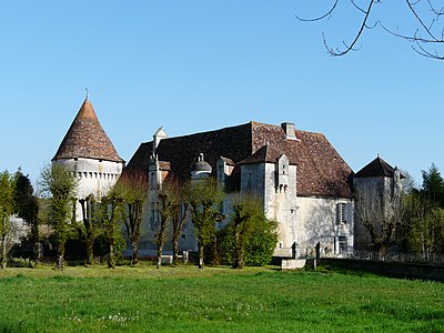
The oldest building in Saint-Front-la-Rivière is the Saint-Front church , which was started in the Romanesque architectural style . This building is in a papal bull of Celestine III. Mentioned from 1192 as Ecclesia S. Frontonis de Riparia . The ruins of the Château de la Renaudie date back to the 13th century . At that time the parish was still called Sanctus Fronto de Ripperia and was one of 27 parishes under the Archpriest of Condat , who had his seat in Champagnac-de-Belair . The Château Saulnier also dates from this period. In the 15th century, which was Château de Pommier built. The Château du Caneau then followed in the 19th century . During the National Convention (1792 to 1795) the parish was named Front-sur-Dronne .
Population development
| Population development in Saint-Front-la Rivière | ||||
|---|---|---|---|---|
| year | Residents |

|
||
| 1962 | 639 | |||
| 1968 | 570 | |||
| 1975 | 586 | |||
| 1982 | 541 | |||
| 1990 | 559 | |||
| 1999 | 543 | |||
| 2004 | 522 | |||
| 2006 | 534 | |||
| 2007 | 532 | |||
| 2009 | 527 | |||
| 2014 | 514 | |||
| 2016 | 530 | |||
| 2017 | 518 | |||
Source: INSEE
Saint-Front-la-Rivière had just over a thousand inhabitants in the middle of the 19th century. From 1886 a steady decline began. After major losses in the 1960s, the population in Saint-Front-la-Rivière has only declined slightly since then.
With an area of 17.89 square kilometers, the municipality has a population density of 29 inhabitants / km².
mayor
Mayor of Saint-Front-la-Rivière has been the non-party mason foreman Maurice Francis Guinot since March 2008.
Attractions
- Romanesque church of Saint-Front with a nave from the 16th century
- Ruins of the Château de la Renaudie from the 13th to the 16th century, monument historique since 1946
- Château Saulnier from the 13th and 16th centuries with a donjon from the 15th century; since 1969 Monument historique
- Château de Pommier from the 15th and 17th centuries , monument historique since 1959
- 19th century Château du Caneau
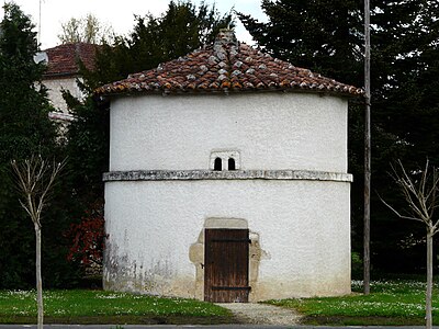
- round pigeon tower in the center.
Photo gallery
Individual evidence
literature
- J.-P. Floc'h ao: Feuille Nontron . In: Carte géologique de la France à 1/50000 . BRGM.


