
Hautefaye
| Hautefaye | ||
|---|---|---|
|
||
| region | Nouvelle-Aquitaine | |
| Department | Dordogne | |
| Arrondissement | Nontron | |
| Canton | Périgord Vert Nontronnais | |
| Community association | Périgord Nontronnais | |
| Coordinates | 45 ° 32 ' N , 0 ° 30' E | |
| height | 139-207 m | |
| surface | 12.47 km 2 | |
| Residents | 136 (January 1, 2017) | |
| Population density | 11 inhabitants / km 2 | |
| Post Code | 24300 | |
| INSEE code | 24209 | |
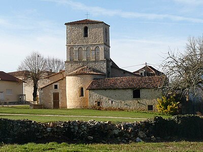
 Notre-Dame de l'Assomption church in Hautefaye from the south |
||

Hautefaye , Occitan Auta FAIA , is a commune with 136 inhabitants (at January 1, 2017) of the North department Dordogne in the region Nouvelle-Aquitaine (before 2016 Aquitaine ). It belongs to the Arrondissement of Nontron and the canton of Périgord Vert Nontronnais (until 2015 canton of Nontron ). The responsible community association is the Communauté de communes du Périgord Nontronnais .
etymology
The Occitan Auta Fàia is composed of auta ( Latin altus ) high and fàia (Latin fagus ) beech , d. H. high beech (pole) forest .
geography
Hautefaye is 13 kilometers west of Nontron (beeline). The municipality is border municipality to the Charente department . It is surrounded by the following 5 communities:
| Mainzac (Charente) | Javerlhac-et-la-Chapelle-Saint-Robert | Javerlhac-et-la-Chapelle-Saint-Robert |
| Mareuil en Périgord (formerly Beaussac) |
.svg)
|
Lussas-et-Nontronneau |
| Mareuil en Périgord (formerly Beaussac ) | Connezac | Lussas-et-Nontronneau |
In addition to the center of Hautefaye , the community consists of the following hamlets, farmsteads and landmarks:
Bel-Air , Chante-Alouette , Couche du Loup , Ferdinas , Fontaine du Brouillac , Grand Acaud , Grand Fayemarteau , Grand Gillou , Jaubertin , La Cigale , La Tuilière , Lage d'Ambelle , Le Clos Neuf , Le Grand Aujaud , Le Grand Lac , Le Lac Noir , Le Maine Aujaud , Le Trou du Loup , Les Bessoux , Les Carmes , Les Coutaudes , Les Farges , Les Greseaux , Les Places , Les Rondilloux , Petit Fayemarteau , Plambeau , Puy Couraud and Vignaud .
The topographically lowest point of the municipality is at 139 meters above sea level at the Fontaine du Brouillac on the southern border, the highest point at 207 meters on a ridge south of the center of Hautefaye . The maximum difference in altitude is 68 meters. The town center is at 192 meters.
Transport links

The center of Hautefaye is on the D 95 from Lussas to Mainzac. The eastern municipality is touched by the D 93, which passes in a north-south direction from Javerlhac to Connezac and Beaussac. Coming from La Chapelle-Saint-Robert in the north, a communal road crosses the town center and then continues to Les Graulges in the south.
Hydrography
Due to karstification in the Dogger, the municipality of Hautefaye does not have any noteworthy streams or rivers. On the southern border there is a source ( Fontaine du Brouillac ), which feeds the Ruisseau de Bretanges , a right tributary of the Nizonne , to the southwest via a dry valley . At Chante-Alouette , a dry valley without any drainage runs northwest to Mainzac. The northern tip of the municipality is also marked by a small dry valley facing northwest, which merges into a large dry valley system that extends as far as Marthon in the direction of Bandiat - the Fond des Toulenches .
geology
The municipality of Hautefaye is completely underlain by shallow sediments of the northeast Aquitaine Basin . Structurally, it belongs to the south-western trough shoulder of the bandiat trench .
The oldest exposed formation comes from the Dogger ( Upper Bathonian - Formation j 1c-3a or j 2-6 (a) ). Above it follows 25 meters thick callovium (formation j 3 or j 2-6 (b) ), which claims a large part of the municipality around the center of Hautefaye . The chalky dogger can also be recrystallized .
In the extreme south as well as at Le Lac Noir two small occurrences of transgressive cenomania (formation c 1-2 ) have been preserved.
The remainder of the municipality is covered by Pleistocene colluvium of fluvial origin (sandy clays and gravels of the Ac formation ). The two arid valleys are filled with Holocene alluvium - brick-red clays and fine sands mixed with pebbles made of quartz, quartzite and limestone (formation Fy-z ).
ecology
The municipality of Hautefaye is an integral part of the Périgord-Limousin Regional Natural Park .
history
The oldest building in the town of Hautefaye is from the Middle Ages derived Romanesque church Notre-Dame de l'Assomption .
On August 16, 1870, at a mass in the village, a criminal case, known as the Hautefaye drama , occurred in which the landowner Alain de Monéys was lynched and burned. The case is to be seen against the background of the war of 1870/71 and the passions it stirred up in the population of the small town. As a result of a simple misunderstanding, Alain de Monéys was believed to be a Prussian , which led to his lynching . Rumors of cannibalism , based on remarks attributed to the mayor and alleged actions of the villagers, exacerbated the barbaric nature of the event. Of the 21 defendants in this murder case, the four chief perpetrators were sentenced to death and another to life-long forced labor. Several books have dealt with this affair. For the writer Georges Marbeck, it symbolizes the ritual murder of the scapegoat , while the historian Alain Corbin sees the reasons for the events more in the peasants' hatred of the nobility .
Population development
| Population development in Hautefaye | ||||
|---|---|---|---|---|
| year | Residents |

|
||
| 1962 | 174 | |||
| 1968 | 169 | |||
| 1975 | 146 | |||
| 1982 | 144 | |||
| 1990 | 129 | |||
| 1999 | 116 | |||
| 2006 | 113 | |||
| 2007 | 113 | |||
| 2008 | 112 | |||
| 2012 | 122 | |||
| 2013 | 124 | |||
| 2015 | 130 | |||
| 2016 | 133 | |||
| 2017 | 130 | |||
Source: INSEE
The population of Hautefaye has steadily decreased since 1962, but has started to recover somewhat since 2008.
Together with the municipality of Soudat, Hautefaye has the second lowest population density in the canton of Périgord Vert Nontronnais after Sceau-Saint-Angel - 11 inhabitants / km².
mayor
The mayor of Hautefaye has been the non-party pensioner Francis Michel Donnary since 1977. He was replaced in March 2014 by the farmer Jean-Marie Portain, who was part of the DVD .
economy
Economic use and business
The economic life in Hautefaye is mainly determined by agriculture (agriculture, animal husbandry) and forestry. As of December 31, 2013, the municipality had 6 companies, including 2 in the agriculture, forestry and fishing sectors, 2 in trade, transport and services, one company in the construction industry and one company in the administration sector.
employment
In 2016, there were 57 people between the ages of 15 and 64 who were able to work, making up 46.7% of the total population. The number of unemployed rose from 3 to 7 people in 2007, the unemployment rate is now 12.3%.
Attractions
- The Romanesque church of Notre-Dame de l'Assomption .
Pilgrimage
Associated with the Church of Notre-Dame de l'Assomption is an annual pilgrimage on August 15th (or the Sunday following), which was first carried out in 1492. Long forgotten, this custom was revived between 1930 and 1940. The procession now has more than 80 participants again.
Landing pad for microlight aircraft
There is a runway for microlights at the Les Jaubertins farm and campsite .
Photo gallery
Notre-Dame de l'Assomption from the northeast
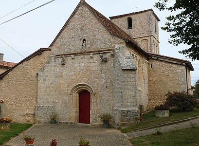
West side of Notre-Dame de l'Assomption

Virgin statue above the tympanum of the entrance portal

school-building

Fountain


literature
- J.-P. Floch, u. a .: Feuille Nontron . In: Carte géologique de la France à 1/50000 . BRGM.
- G. Le Pochat et al .: Montbron . In: Carte géologique de la France at 1/50 000 . BRGM, 1986.
Web links
- Website with Occitan place names in the Dordogne department
- Hautefaye on the annuaire-mairie.fr website
- Hautefaye on cartesfrance.fr (French)
- Population development since 1793 on cassini.ehess.fr
Individual evidence
- ^ Georges Marbeck: Hautefaye. L'Année terrible. Robert Laffont, Paris 1982, ISBN 2-221-01056-6 .
- ↑ Hautefaye on the Insee website.
- ↑ Alberte Sadouillet-Perrin and Guy Mandon, with illustrations by Paul Laparre: Pèlerinages en Périgord . éd. Pierre Fanlac, Périgueux 1985, ISBN 2-86577-079-6 , pp. 158 .