
Saint-Front-sur-Nizonne
|
Saint-Front-sur-Nizonne Sent Front de Champs Niers |
||
|---|---|---|
|
||
| region | Nouvelle-Aquitaine | |
| Department | Dordogne | |
| Arrondissement | Nontron | |
| Canton | Périgord Vert Nontronnais | |
| Community association | Périgord Nontronnais | |
| Coordinates | 45 ° 29 ′ N , 0 ° 38 ′ E | |
| height | 153-263 m | |
| surface | 13.05 km 2 | |
| Residents | 157 (January 1, 2017) | |
| Population density | 12 inhabitants / km 2 | |
| Post Code | 24300 | |
| INSEE code | 24411 | |
 Church Saint-Front Saint-Front-sur-Nizonne |
||

Saint-Front-sur-Nizonne ( Occitan Sent Front de Champs Niers ) is a commune of 157 inhabitants (at January 1, 2017) of the North department Dordogne in the region Nouvelle-Aquitaine . It belongs to the Arrondissement of Nontron and the canton of Périgord Vert Nontronnais (until 2014: Nontron ). The responsible community association is the Communauté de communes du Périgord Nontronnais . The inhabitants are known as Saint-Frontois or Saint-Frontoises .
etymology
The name of the municipality of Saint-Front-sur-Nizonne is derived from the Holy Fronto (Sanctus Fronto) and the river Nizonne . The North Occitan name Champs Niers means black fields and alludes to the fertile soil.
geography
Saint-Front-sur-Nizonne is just under six kilometers south-southwest of Nontron and 32 kilometers north of Périgueux .
The municipality is surrounded by the following five neighboring municipalities:
| Saint-Martial-de-Valette | ||
| Mareuil en Périgord (formerly Champeaux-et-la-Chapelle-Pommier ) |
.svg)
|
Sceau-Saint-Angel |
| Brantôme en Périgord (formerly Saint-Crépin-de-Richemont ) | La Chapelle-Montmoreau |
The municipal area of Saint-Front-sur-Nizonne includes the following hamlets, farms, an estate and landmarks:
Bobastanchas , Bois des Charrets , Bois du Grand Clos , Brissonneau , Domaine de Bagatelle , Ferme de Bagatelle , Eyport , Filoine , Forêt de Puyberaud , Grands Taillis , La Chaise , La Croix , Laugeas , Le Lac du Couteau , Le Meynot , Le Repaire , Les Grandes Terres , Les Grands Bois , Les Landes du Lac Nègre , Les Mines , Les Nouailles , Les Pouges , Puybaronneau and Puyberaud .
The topographically lowest point of the municipality is at 153 meters above sea level on the Nizonne in the west, the highest point at 263 meters at Brissoneau (municipality boundary to Sceau-Saint-Angel) in the extreme northeast. The maximum height difference is 110 meters. The town center is located at 176 meters above sea level.
Transport links
On the western edge of the municipality, the D 84 runs from Nontron to Distributionlac . Shortly before crossing the Nizonne, a municipal road branches off to the left, which leads east to the town center. Two municipal roads leave the town center to the north; they both establish a connection to Saint-Martial-de-Valette, with the right branching off to the D 675 (Nontron - Brantôme). From the town center there is also a municipal road to the south, which either leads back to the D 84 or turns off to La Chapelle-Montmoreau or to Saint-Crépin-de-Richemont.
Hydrography
The municipality is traversed roughly in the middle by the Nizonne in a westerly direction. The upper course of the Nizonne is dammed into ponds . The river has two right and several small left side valleys, which are laid out as dry valleys and only carry water when there is greater rainfall in the winter half-year. The last left side valley in the southwest - Grenzbach zu Champeaux-et-la-Chapelle-Pommier is an exception. A borehole was drilled into the gravel of the Nizonne near Puybaronneau , which now maintains the canton's drinking water supply.
geology

The commune of Saint-Front-sur-Nizonne is bounded to the north and south by ridges, which are covered on the surface by Pleistocene alluvium and colluvium of fluvial origin (formations Ac and Acf ). Standing rock (sediments of the northeastern Aquitaine Basin ) occurs only in the Nizonn Valley and in smaller deposits on the northern and southern ridges. On the northern ridge there are fine-grain, beige-colored oolite limestone of the Oxfordian ( Dogger ) as a stratigraphically deepest unit near Bobastanchas . Cenomanium transgressing above it appears on the northern border at Rapevache . The Nizonne exposed flat limestones of the Turonian ( Ligérien and lower Angoumien ).
On the southern ridge at Le Lac du Couteau , Filoine and Bagatelle there are occurrences of rock-forming river gravel (formation HF ), which may be of an Eocene age. They are only the beginning of a very extensive fossil river system that extends to the southwest until shortly before Léguillac-de-Cercles . It illustrates a significantly increased erosion activity in the Massif Central at the time. A comparable, approximately 20 meter thick deposit of lake sediments and river gravel (with probably Eocene / Oligocene Sidérolithique ) also covers the ridge around Les Landes . At the altitude around Brissonneau there are old Pleistocene sands and gravels with quartz pebbles (formation Fs ).
In the valley of the Nizonne lies alluvium of the Würm glacial period and the Holocene (formation K ). The small left side valley of the Nizonne south of Puyberaud is filled with limestone debris from the last Ice Age (formation GP ).
ecology
The municipality of Saint-Front-sur-Nizonne is an integral part of the Périgord-Limousin Regional Natural Park .
history
At the Domaine de Bagatelle there are remains of a Roman road . The Romanesque church in the center of Saint-Front-sur-Nizonne dates from the 12th century. Le Repaire is a medieval residence from the mid-13th century.
In accordance with the Occitan name, the municipality was called Saint Front de Champnier until 1793 , and in 1801 the spelling was changed to Saint-Front-de-Champnier . The current name has existed since 1912.
Population development
| Population development in Saint-Front-sur-Nizonne | ||||
|---|---|---|---|---|
| year | Residents |

|
||
| 1962 | 145 | |||
| 1968 | 94 | |||
| 1975 | 95 | |||
| 1982 | 91 | |||
| 1990 | 122 | |||
| 1999 | 133 | |||
| 2006 | 138 | |||
| 2007 | 138 | |||
| 2012 | 151 | |||
| 2016 | 157 | |||
| 2017 | 157 | |||
Source: INSEE
Saint-Front-sur-Nizonne lost a third of its population in the 1960s. However, the population has been increasing again since 1982 and has now even surpassed its old level.
With an area of 13.05 square kilometers, the population density is 12 inhabitants / km².
mayor
Mayor of Saint-Front-sur-Nizonne has been Michel Gaborit since September 2010.
economy
On the northern edge of the municipality of Saint-Front-sur-Nizonne is the central garbage collection point ( French : Déchetterie ) of the canton Périgord Vert Nontronnais in Pleistocene sands .
Attractions
- Romanesque church of Saint-Front from the 12th century
- medieval residence Le Repaire from the 13th century
- Good Domaine de Bagatelle , in part from the 17th century
- Puyberaud estate , early 18th century
- Manor house in the town center
Photo gallery
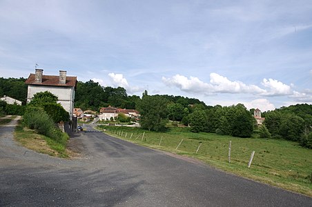 Town view from the west
 source
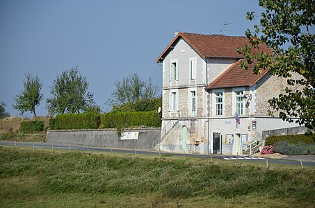 Mairie
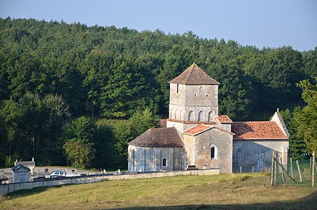 The Saint-Front church from the northeast
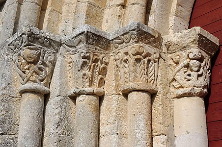 Capitals on the entrance portal of Saint-Front


Individual evidence
literature
- J.-P. Floc'h ao: Feuille Nontron . In: Carte géologique de la France à 1/50000 . BRGM.