
Connezac
| Connezac | ||
|---|---|---|
|
||
| region | Nouvelle-Aquitaine | |
| Department | Dordogne | |
| Arrondissement | Nontron | |
| Canton | Périgord Vert Nontronnais | |
| Community association | Périgord Nontronnais | |
| Coordinates | 45 ° 31 ' N , 0 ° 32' E | |
| height | 118-209 m | |
| surface | 5.78 km 2 | |
| Residents | 74 (January 1, 2017) | |
| Population density | 13 inhabitants / km 2 | |
| Post Code | 24300 | |
| INSEE code | 24131 | |
.JPG) Château de Connezac |
||

Connezac , Occitan Conasac , is a French municipality with 74 inhabitants (at January 1, 2017) of the North department Dordogne in the region Nouvelle-Aquitaine (before 2016 Aquitaine ). It belongs to the Arrondissement of Nontron and the canton of Périgord Vert Nontronnais (until 2015 canton of Nontron ). The responsible community association is the Communauté de communes du Périgord Nontronnais . The inhabitants are referred to as Connezacois or Connezacoises .
etymology
Connezac is derived from the Gallo-Roman proper name Conatius , followed by the suffix -acum as an indication of the place or ownership.
geography
The municipality of Connezac is eight kilometers north-east of Mareuil and eleven kilometers west-southwest of Nontron (as the crow flies).
It is surrounded by the following 4 communities:
| Hautefaye | ||
| Mareuil en Périgord (formerly Beaussac ) |
.svg)
|
Lussas-et-Nontronneau |
| Rudeau-Ladosse |
The community has no town center. In addition to the Château de Connezac, it consists of the following hamlets, farms and landmarks: Fontenille , Lafarge , Le Lac Noir , Le Maine , Les Maisons Brûlées , Les Pouyaux , Maine du Bost , Maine Rousset and Roncevaux .
The Mairie is located in Maine Rousset .
The topographically lowest point of the municipality is 118 meters above sea level on the Ruisseau de Beaussac in the southwest, the highest point at 209 meters a little south of the hamlet of Lafarge . The absolute height difference is 91 meters. The Mairie in Maine Rousset is 200 meters above sea level.
In terms of area, Connezac is the smallest municipality in the canton of Périgord Vert Nontronnais and also has the fewest inhabitants.
Transport links

On the western edge of the municipality of Connezac, the D 93 from Javerlhac leads south towards Beaussac . A municipal road branches off from it in the northwest corner, which connects the individual districts with each other and then joins the D 93 again at the southwest corner. Along the northern border, the D 95 runs in a north-westerly direction from Lussas to Hautefaye and Mainzac ( Département Charente ). The eastern border is touched by a municipal road that creates a north-south cross connection between the D 95 and the D 87 (Nontron-Beaussac).
Hydrography
The southern border of the municipality of Connezac is formed by the Ruisseau de Beaussac , a right branch of the Nizonne . The stream rises east of Lussas. The Ruisseau de Beaussac still has a small right branch that rises in the western part of the municipality and then runs along the south-west border to open at the south-west corner.
geology

The municipality of Connezac lies entirely on sediments of the Aquitaine Basin . Structurally, it belongs to the northeast wing of the southeast-trending Synkline Combiers-Saint-Crépin-de-Richemont .
Oldest pending rocks are flat-lying limestones of the Dogger ( Upper Bathonian / Oxfordian - Formation J2-6 (b) ) to see east of Fontenille . It is an alternation of white, chalky limestone and beige oolite limestone . In the southwest corner of the municipality then enters transgressive Cenomanium on (Formation c1-2 - grobdetritische, bioclastic limestones and gray-green marls rich in oysters ), which in the vicinity of the castle from Ligérien (white, chalky limes from the Unterturon - Formation c3a ) is superimposed .
The rest of the municipality is covered by Pleistocene colluvium (Formation Ac - fluviatile clays and gravel ). In the valley of the Ruisseau de Beaussac and its right tributary is alluvium from the Würm glacial period and the Holocene (Formation K ).
ecology
The municipality of Connezac formed an integral part of the Périgord-Limousin Regional Natural Park from 1998 to August 2011 . However, the contract was then not extended, which is why the municipality no longer belongs to the nature park.
history
The Château de Connezac dates back to the 16th century .
The community was Connezac 1793 still Connesac and 1801 Connezat .
Population development
| Population development in Connezac | ||||
|---|---|---|---|---|
| year | Residents |
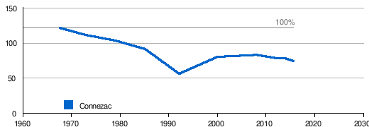
|
||
| 1962 | 121 | |||
| 1968 | 111 | |||
| 1975 | 103 | |||
| 1982 | 91 | |||
| 1990 | 56 | |||
| 1999 | 82 | |||
| 2006 | 82 | |||
| 2007 | 82 | |||
| 2008 | 83 | |||
| 2012 | 79 | |||
| 2013 | 78 | |||
| 2015 | 78 | |||
| 2017 | 74 | |||
Source: INSEE
The municipality of Connezac had lost over half of its inhabitants by 1990. Since then, the population has stabilized again.
With an area of 5.78 square kilometers, the population density is 13 inhabitants / km².
mayor
Since March 2008, the mayor of Connezac was the non-party, retired military man François Waroux. He was replaced by Thierry Pasquet in March 2014.
economy
employment
In 2012, the working age population aged between 15 and 64 was 33, which is 41.8% of the total population. The number of unemployed has decreased from 4 to just one person since 2007, the unemployment rate is thus 3.0%.
Companies
As of December 31, 2013, 8 companies were located in the municipality, including 3 in the construction industry, 2 in the administration, education, health or social sector, one company in agriculture, forestry and fishing, one company in the trade, transport or services sector and one company in the industry.
Attractions
- The privately owned Château de Connezac from the 16th and 17th centuries, monument historique since 1945.
- The parish church of Saint-Martin , former castle chapel and also monument historique.
Photo gallery
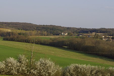 Connezac from the west
 The Mairie of Connezac in Rousset Maine
 Wayside cross
 The Saint-Martin castle chapel
 Stained glass window with Saint Peter
 Château de Connezac
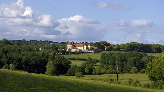 Connezac from the south
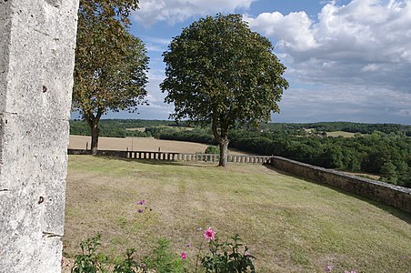 View from the castle to the east


.JPG)


literature
- J.-P. Floc'h, among others: Feuille Nontron . In: Carte géologique de la France à 1/50000 . BRGM.
Web links
- Website with Occitan place names in the Dordogne department
- Connezac on the annuaire-mairie.fr website
- Connezac on cartesfrance.fr (French)
- Population development since 1793 on cassini.ehess.fr