
Rudeau-Ladosse
|
Rudeau-Ladosse Rudeu e Ladaussa |
||
|---|---|---|
|
||
| region | Nouvelle-Aquitaine | |
| Department | Dordogne | |
| Arrondissement | Nontron | |
| Canton | Brantôme | |
| Community association | Dronne et Belle | |
| Coordinates | 45 ° 29 ′ N , 0 ° 33 ′ E | |
| height | 115-203 m | |
| surface | 13.74 km 2 | |
| Residents | 160 (January 1, 2017) | |
| Population density | 12 inhabitants / km 2 | |
| Post Code | 24340 | |
| INSEE code | 24221 | |
 Church Saint-Jean in Rudeau |
||

The French community Rudeau-Ladosse , Occitan Rudeu e Ladaussa , located in the northwest of the department Dordogne in the region Nouvelle-Aquitaine . It has 160 inhabitants (as of January 1, 2017) and belongs to the canton of Brantôme . The responsible community association is the Communauté de communes Dronne et Belle . The inhabitants are called Rudeaussois or Rudeaussoises .
etymology
The origin of the Occitan names Rudeu and Ladaussa is obscure, it is possible that they are proper names.
geography
Rudeau-Ladosse (or the center of Rudeau ) is located in the Périgord vert , about eight kilometers northeast of Mareuil and 10 kilometers southwest of Nontron (as the crow flies). The municipality is surrounded by the following three neighboring municipalities:
| Connezac | Lussas-et-Nontronneau | |
| Mareuil en Périgord (formerly Beaussac ) |
.svg)
|
Mareuil en Périgord (formerly Champeaux-et-la-Chapelle-Pommier ) |
| Mareuil en Périgord (formerly Puyrenier ) | Mareuil en Périgord (formerly Saint-Sulpice-de-Mareuil ) |
In addition to the centers of Rudeau and Ladosse , the municipality consists of the following hamlets, farmsteads, an estate, castles and landmarks:
Bélussière , Bois de Rudeau , Château de Bellussière , Château des Combes , Geriac , Grands Bois , La Brousse , La Grande Métairie , La Grande Pièce , La Grange de Cacal , La Rousselière , La Vigne des Combes , Le Communal , Le Goupillou , Le Planchou , Le Pouzet , Les Brandichous , Les Chazeaux , Les Combes , Les Fayes , Les Plagnes , Leycoussaudie , Milauvieux , Puy Choisi , Roussiaud , Teignac , Terre des Perriers and Terres des Rocs .
The much more important center of Rudeau is positioned very eccentrically - it is located in the southeast corner of the municipality on a southern slope above the Nizonne . Ladosse is 4 kilometers further west on the western corner.
The topographically lowest point in the municipality of Rudeau-Ladosse at 115 meters above sea level is at the confluence of the Nizonne and the Ruisseau de Beaussac (at the Pont du Râteau on the western corner). The highest point at 203 meters is in the northeast, a little north of La Grange de Cacal . The absolute height difference is 88 meters.
Transport links

The center of Rudeau is on the D 708 from Nontron to Mareuil. From Rudeau there is a connection via the D87 to Beaussac in the west. Furthermore, a municipal road runs east along the Nizonne to Champeaux . Ladosse can be reached by a local road from Beaussac; it branches off the D 87 in a south direction immediately south of Beaussac, crosses the center of Ladosse and then continues to Nizonne and Saint-Sulpice-de-Mareuil.
Hydrography
The southern border of the municipality with Saint-Sulpice-de-Mareuil is formed by the Nizonne flowing to the west. Upon reaching the former municipal boundary of Puyrenier, the river then turns to the northwest. The Ruisseau de Beaussac flows through the north of the municipality, coming from Lussas and seasonally drying up in its upper reaches near La Brousse . It also drains to the west and flows into the Nizonne at the Pont du Râteau as a right branch. From Leycoussaudie, the stream forms the northern border to Connezac and then the north-western border to Mareuil en Périgord (Beaussac).
geology
The entire municipality is underlain by flat sediments of the northern Aquitaine Basin . Structurally, the surrounding rocks belong to the Combiers-Saint-Crépin-de-Richemont Syncline . The oldest open-ended formation is the Oxfordium , which lines the upper reaches of the Ruisseau de Beaussac near La Brousse . It consists of beige-colored, fine-grain limestone . The transgressive cenomanium lies above the Oxfordium and can be seen further down the valley until shortly before Beaussac. The cenomanium consists of three units - green, oyster- bearing marls , fine-grained sands and sandy alveoline limestones . This is followed by the Turonium with the chalk limestone of the Ligérien and the Rudist limestone of Angoumiens . The Ligérien follows the left bank of the Ruisseau de Beaussac . The entire southern part of the municipality is occupied by the Angoumien. The eastern section ( Bois de Rudeau ) is covered by the Pleistocene colluvium . Würmzeitlicher slope debris filled the upper reaches of the Ruisseau de Baussac . The sediments in the floodplains of the Ruisseau de Beaussac and the Nizonne originate from the Holocene .
South of Ladosse, two faults move east-south-east. The northern branch can be followed as far as Rudeau, the southern branch towards the Nizonne. The two faults, in turn, are crossed by a northeast trending fault. This fault system is likely to be associated with the bending up of the strata through the Mareuil anticline, a little further south-west .
The Angoulême formation des Angoumiens was once dismantled as a building block at the Château de Belussière .
ecology

Natural park
The municipality of Rudeau-Ladosse has been an integral part of the Périgord-Limousin Regional Natural Park since 1998 .
ZNIEFF
The valley lowlands of the Nizonne and the Ruisseau de Beaussac are under nature protection and form a type 2 ZNIEFF ( French zone naturelle d'intérêt écologique, faunistique et floristique ) in the municipality under the name "Vallée de la Nizonne" .
The fauna found consists of around 130 species, 30 of which are considered characteristic. Among the 20 species of mammals are to lead the otter Lutra lutra and the European mink Mustela nutreola and 18 species of bats , including Barbastelle ( Barbastella barbastellus ), greater mouse-eared ( Myotis myotis ), greater horseshoe bat ( Rhinolophus ferrumequinum ), Schreiber's bat ( Miniopterus schreibersii ), whiskered bat ( Myotis mystacinus ), Geoffroy's bat ( Myotis emarginatus ), Bechstein's bat ( Myotis bechsteinii ), Daubenton's bat ( Myotis daubentonii ), Natterer's bat ( Myotis nattereri ), noctule ( Nyctalus noctula ) Gray long-eared ( Plecotus austriacus ), brown long-eared ( Plecotus auritus ), Small mouse ear ( Myotis blythii ), Lesser horseshoe bat ( Rhinolophus hipposideros ), Kuhl's pipistrelle ( Pipistrellus kuhlii ), Pipistrelle ( Pipistrellus nathusii ) and serotine ( Eptesicus serotinus ). These include, furthermore, the two amphibians European frog ( Hyla arborea ) and marble pig ( Triturus marmoratus ), the tortoise European Terrapin ( Emys orbicularis ), the butterflies phengaris rebeli ( Phengaris rebeli ), Heller burnet Ant Bläuling ( Phengaris teleius ), Large Feuerfalter ( Lycaena dispar ), valley current Wiesenvögelchen ( Coenonympha oedippus ) and the vials helmet Azurjungfer ( Coenagrion mercuriale ), orange-spotted emerald ( Oxygastra curtisii ) and French Clubtail ( Gomphus graslinii ).
The flora consists of over 200 plant species , 9 of which are considered characteristic - including chess flower ( Fritillaria meleagris ), lung gentian ( Gentiana pneumonanthe ), gray sunflower ( Helianthemum canum ), loose-flowered orchid ( Anacamptis laxiflora ), Nice stonecrop ( Sedum sediforme ), yellow meadow rue ( Thalictrum flavum ), the sandwort Arenaria controversa , forest ledges ( Scirpus sylvaticus ) and misunderstood water hose ( Utricularia australis ).
Another type 2 ZNIEFF under the name “Bois de Beaussac” exists near Milauvieux along the northern slope of the Nizonne. However, this protected area is only very small with 7 hectares - its main part belongs to the municipalities of Mareuil en Périgord (Beaussac), Connezac and Hautefaye . The sandwort taxon Arenaria controversa is characteristic .
Type 1 is also represented with two protected areas. One of the two areas protects the alkaline swamp lowlands in the Nizonne Valley. With the exception of the bats, their fauna is identical to the ZNIEFF «Vallée de la Nizonne» described above. The flora is reduced to chess flower, lung gentian, yellow meadow rue and misjudged water hose. The characteristic taxon of this shallow water zone is the common arrow herb ( Sagittaria sagittifolia ).
Natura 2000
The Nizonne Valley also falls under Natura 2000 with special protection for 17 of the species already listed plus scabiosa butterfly ( Euphydryas aurinia ), scheldegroppe ( Cottus perifretum ) and brook lamprey ( Lampetra planeri ).
history
The oldest surviving building in Rudeau-Ladosse is the Château de Belussière from the 11th century. The Château des Combes dates back to the 16th century. The noble manor ( French gentilhommière ) La Rousselière goes back to the 17th century . The local church of Saint-Jean in Rudeau was only built in the 19th century. Until 1950 the municipality was only called Ladosse ; on the Cassini map from 1756 to 1789 it functions as la Dosse , in 1793 it is mentioned as Ladausse .
Population development
| Population development in Rudeau-Ladosse | ||||
|---|---|---|---|---|
| year | Residents |

|
||
| 1962 | 348 | |||
| 1968 | 268 | |||
| 1975 | 262 | |||
| 1982 | 245 | |||
| 1990 | 216 | |||
| 1999 | 157 | |||
| 2005 | 167 | |||
| 2006 | 167 | |||
| 2008 | 170 | |||
| 2010 | 178 | |||
| 2015 | 161 | |||
| 2016 | 161 | |||
| 2017 | 160 | |||
Source: INSEE
The population development in Rudeau-Ladosse is declining very strongly, the population has decreased by more than 50% compared to 1962. However, since 1999 a stabilization trend seems to have started.
With an area of 13.74 square kilometers, the population density is 12 inhabitants / km², the third lowest in the canton of Brantôme.
Attractions
- Castle Château de Belussière from the 11th and 12th centuries
- Castle Château des Combes from the 16th century
- Gentilhommière de la Rousselière manor from the 17th century
- 19th century local church of Saint-Jean in Rudeau
Photo gallery
 The dammed Nizonne at Château Lavergne - southern border to Saint-Sulpice-de-Mareuil
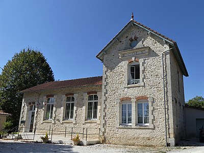 Town hall and school
 Castle Château de Belussière
 Chapel of the Château de Belussière
 Château des Combes castle
 Gentilhommière La Rousselière
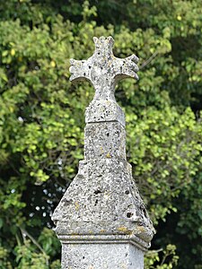 Cross in Ladosse


.JPG)
.jpg)
.JPG)

.jpg)
Individual evidence
Web links
- Rudeau-Ladosse on the website of www.annuaire-mairie.fr
- Rudeau-Ladosse on cartesfrance.fr in French
- Population development since 1793 on cassini.ehess.fr