
Angoisse
|
Angoisse Engoissa |
||
|---|---|---|
|
||
| region | Nouvelle-Aquitaine | |
| Department | Dordogne | |
| Arrondissement | Nontron | |
| Canton | Isle-Loue-Auvézère | |
| Community association | Isle-Loue-Auvézère en Périgord | |
| Coordinates | 45 ° 26 ' N , 1 ° 8' E | |
| height | 239-364 m | |
| surface | 23.13 km 2 | |
| Residents | 588 (January 1, 2017) | |
| Population density | 25 inhabitants / km 2 | |
| Post Code | 24270 | |
| INSEE code | 24008 | |

Angoisse ( Occitan : Engoissa ) is a municipality with 588 inhabitants (as of January 1, 2017) in the French department Dordogne in the Nouvelle-Aquitaine region . The municipality belongs to the Arrondissement of Nontron and the canton of Isle-Loue-Auvézère (until 2015: canton of Lanouaille ). The inhabitants are called Angoissais .
geography
Angoisse is about 40 kilometers northeast of Périgueux . Angoisse is surrounded by the neighboring communities of Sarlande in the north and west, Payzac in the east, Savignac-Lédrier in the southeast and Lanouaille in the south.
In the southeast of the municipality is the Lac de Rouffiac de Périgord .
Population development
| 1962 | 1968 | 1975 | 1982 | 1990 | 1999 | 2006 | 2013 |
|---|---|---|---|---|---|---|---|
| 871 | 834 | 721 | 619 | 559 | 572 | 598 | 637 |
| Source: Cassini and INSEE | |||||||
Attractions
- Saint Martin Church
- Bouché Castle
- Rouffiac Castle from the 15th century, alterations from the 17th century, Monument historique

Saint Martin Church
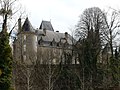
Rouffiac Castle
.JPG)
.JPG)
Web links
Commons : Angoisse - collection of images, videos and audio files