Savignac-de-Nontron
|
Savignac-de-Nontron Savinhac de Nontronh |
||
|---|---|---|
|
|
||
| region | Nouvelle-Aquitaine | |
| Department | Dordogne | |
| Arrondissement | Nontron | |
| Canton | Périgord Vert Nontronnais | |
| Community association | Périgord Nontronnais | |
| Coordinates | 45 ° 33 ' N , 0 ° 43' E | |
| height | 185-303 m | |
| surface | 9.69 km 2 | |
| Residents | 191 (January 1, 2017) | |
| Population density | 20 inhabitants / km 2 | |
| Post Code | 24300 | |
| INSEE code | 24525 | |
Savignac-de-Nontron ( Occitan Savinhac de Nontronh ) is a commune of 191 inhabitants (at January 1, 2017) of the North department Dordogne in the region Nouvelle-Aquitaine . It belongs to the Arrondissement of Nontron and the canton of Périgord Vert Nontronnais (until 2014: Nontron ). The responsible community association is the Communauté de communes du Périgord Nontronnais . The inhabitants are known as Savignacois or Savignacoises .
geography
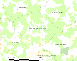
Savignac-de-Nontron is four kilometers northeast of Nontron and seven kilometers west of Saint-Saud-Lacoussière .
Savignac-de-Nontron is surrounded by the following five municipalities:
| Augignac | Augignac | Abjat-sur-Bandiat |
| Nontron |

|
|
| Nontron | Saint-Pardoux-la-Rivière (point of contact) | Champs-Romain |
The municipal area of Savignac-de-Nontron includes the following hamlets, farms, a former blacksmith's shop and landmarks:
Aumont , Brouillaud , Chez Baillot , Durentière , Étang de Sallat , Forêt Domaniale de Savignac-de-Nontron , Forge Basse , La Forêt , Labesse , Lavenaud , Les Châtres , Les Cheyroux , Les Landes , Maison Neuve , Malibas , Maupuy and Mendet .
The topographically lowest point of the municipality is 185 meters above sea level at Brouillaud am Bandiat in the southwest, the highest point at 303 meters on a ridge near Maupuy in the south. The maximum height difference is 118 meters.
Transport links
The south-eastern border of the municipality is touched by the main traffic axis D 85 from Nontron to Châlus ( Haute-Vienne department ). From here the D 79 branches off at Maupuy and leads into the center of Savignac-de-Nontron and then down into the Bandiattal. Here it meets the D87 from Abjat-sur-Bandiat to Nontron near Lavenaud .
Hydrography
The municipality is traversed roughly in the middle by the Bandiat in a south-south-west direction. A small left tributary of the Bandiat is the Ruisseau du Pont Rompu de Sallat , which flows north of the town center in a west-northwest direction towards the Bandiat.
geology
The municipality of Savignac-de-Nontron is largely located on the Piégut-Pluviers-Granodiorit (with coarse-grained normal facies γ 3M ). The granodiorite is traversed by up to 30 centimeters thick, light aplite tunnels. Some faults also occur near the center of the village and at Aumont , which strike northwest and north-northwest. The granodiorite around Les Cheyroux is mostly deeply weathered to form alterites.
The ridge that passes in the southeast consists of mica-rich paragneiss from the sillimanite zone ( ζ 1-2 ). The contact between the granodiorite and the paragneiss in the southeast of the town center is not abrupt, but extends over an area of around 100 meters; In this contact zone granodiorite and paragneiss alternate with each other until the activated granodiorite trains finally disappear completely. The foliation of the paragneiss strikes west to northwest and falls mostly north or northeast. The dip is quite steep at 60 to 90 degrees and can even point in the opposite direction - which indicates a folding of the paragneiss. To the southeast of Labesse , the paragneiss contains a northwest- trending graphite train ( gra ).
The high altitudes at Maupuy are covered by colluvium with reclaimed basement rock (Formation AC ), which probably originates from the Würm glacial period . It consists mainly of sands and quartz rubble , the latter arising from quartz bands in the paragneiss.
ecology
Natural park
The municipality of Savignac-de-Nontron forms an integral part of the Périgord-Limousin Regional Natural Park .
Protected areas
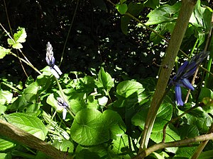
The valley of the Bandiats and the lower reaches of two of its side streams are designated as "Vallées du réseau hydrographique du Bandiat" as protected areas of continental type 1 ( French ZNIEFF - zone naturelle d'intérêt écologique, faunistique et floristique ). The flora consists of around 100 species, of which the two taxa Great Odermennig ( Agrimonia procera ) and Atlantic hare bells ( Hyacinthoides non-scripta ) are considered characteristic.
The dense forest area around Les Cheyroux along the D 85 is designated as a domain forest ( Forêt Domaniale de Savignac-de-Nontron ).
Population development
| Population development in Savignac-de-Nontron | ||
|---|---|---|
| year | Residents |

|
| 1962 | 242 | |
| 1968 | 205 | |
| 1975 | 191 | |
| 1982 | 174 | |
| 1990 | 189 | |
| 1999 | 187 | |
| 2006 | 191 | |
| 2007 | 192 | |
| 2008 | 192 | |
| 2013 | 192 | |
| 2016 | 190 | |
| 2017 | 191 | |
Source: INSEE
The population had suffered severe losses until 1982, but then stabilized.
With an area of 9.69 square kilometers, Savignac-de-Nontron is a very small municipality in the canton of Périgord Vert Nontronnais. Their population density is 20 inhabitants / km².
mayor
Mayor of Savignac-de-Nontron has been the non-party carpenter Bernard Martin since March 2008. René Gardillou has been the new mayor since April 2014.
Attractions
- Saint-Pierre-ès-Liens church
Photo gallery
Individual evidence
literature
- B. Briand et al .: Feuille Châlus . In: Carte géologique de la France at 1/50 000 . BRGM.
- P.-L. Guillot and others: Feuille Thiviers . In: Carte géologique de la France . BRGM.
- G. Le Pochat and others: Feuille Montbron . In: Carte géologique de la France at 1/50 000 . BRGM, 1986.


