Mareuil en Périgord
| Mareuil en Périgord | ||
|---|---|---|
|
|
||
| region | Nouvelle-Aquitaine | |
| Department | Dordogne | |
| Arrondissement | Nontron | |
| Canton | Brantôme | |
| Community association | Dronne et Belle | |
| Coordinates | 45 ° 27 ' N , 0 ° 27' E | |
| height | 98-251 m | |
| surface | 150.48 km 2 | |
| Residents | 2,342 (January 1, 2017) | |
| Population density | 16 inhabitants / km 2 | |
| Post Code | 24340 | |
| INSEE code | 24253 | |
| Website | Mareuil en Périgord | |
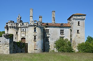
 Mareuil - Château |
||
Mareuil en Périgord is a large French municipality with 2,342 inhabitants (as of January 1, 2017) in the north-west of the Dordogne department in the Nouvelle-Aquitaine region (before 2016 Aquitaine ). It belongs to the Arrondissement of Nontron and the Canton of Brantôme .
The municipality was created with effect from January 1, 2017 as Commune nouvelle by amalgamating the previously independent municipalities of Beaussac , Champeaux-et-la-Chapelle-Pommier , Les Graulges , Léguillac-de-Cercles , Mareuil , Monsec , Puyrenier , Saint-Sulpice -de-Mareuil and Vieux-Mareuil , which have the status of a Commune déléguée in the new municipality . The main town and seat of the town hall (mairie) is Mareuil.
Community structure
| District | former INSEE code |
Area (km²) |
Population (2016) |
|---|---|---|---|
| Beaussac | 24033 | 18.05 | 165 |
| Champeaux-et-la-Chapelle-Pommier | 24099 | 23.48 | 163 |
| Les Graulges | 24203 | 4.13 | 61 |
| Léguillac-de-Cercles | 24235 | 21.47 | 292 |
| Mareuil (administrative headquarters) | 24253 | 25.13 | 1.002 |
| Monsec | 24283 | 12.45 | 199 |
| Puyrenier | 24344 | 7.42 | 57 |
| Saint-Sulpice-de-Mareuil | 24503 | 11.35 | 112 |
| Vieux-Mareuil | 24579 | 27.00 | 344 |
Location and climate
The nine towns of the large municipality of Mareuil en Périgord are located in the Périgord vert approx. 40 to 50 km (driving distance) northwest of Périgueux and approx. 90 to 100 km southwest of Limoges near the border with the Charente department at altitudes of approx. 115 to 180 m . The Belle River flows through the community.
With over 150 square kilometers, the municipality has the largest municipal area in the Dordogne department. At the same time it owns most of the neighboring communities, including three in the neighboring department of Charente. The neighboring communities are:
- in the north Hautefaye , Connezac and Rudeau-Ladosse ,
- in the northwest of Lussas-et-Nontronneau , Saint-Martial-de-Valette and Saint-Front-sur-Nizonne ,
- in the east Brantôme en Périgord (Saint-Crépin-de-Richemont) and Saint-Félix-de-Bourdeilles ,
- in the southeast Brantôme en Périgord (La Gonterie-Boulouneix) and Paussac-et-Saint-Vivien ,
- to the south Saint-Just and La Tour-Blanche-Cercles ,
- in the southwest of La Chapelle-Montabourlet and Gout-Rossignol ,
- to the west Sainte-Croix-de-Mareuil as well
- in the northwest Combiers , Charras and Mainzac (all in the Charente department ).
The climate is temperate; Rain (approx. 800 mm / year) falls over the year.
Population development
| year | 1851 | 1901 | 1954 | 2014 |
| Residents | 7,345 | 4,956 | 3,407 | 2,451 |
The continuous population decline of the individual communities in the 20th century is essentially due to the mechanization of agriculture , the abandonment of small farms, the resulting loss of jobs and the migration of many villagers to the cities.
economy
The community is still largely agriculturally oriented, with livestock also playing a significant role. Craftsmen and small service providers of all kinds have settled in the towns themselves.
history
see local article. The new large congregation was founded on January 1, 2017.
Attractions
see local article
Web links
Individual evidence
- ↑ Population figures retrospectively from January 1, 2016
- ^ Mareuil - map with altitude information
- ↑ Mareuil - climate tables
