
Saint-Just (Dordogne)
|
Saint-Just Sent Just |
||
|---|---|---|
|
||
| region | Nouvelle-Aquitaine | |
| Department | Dordogne | |
| Arrondissement | Périgueux | |
| Canton | Brantôme | |
| Community association | Pays Ribéracois | |
| Coordinates | 45 ° 20 ′ N , 0 ° 30 ′ E | |
| height | 94-178 m | |
| surface | 11.20 km 2 | |
| Residents | 136 (January 1, 2017) | |
| Population density | 12 inhabitants / km 2 | |
| Post Code | 24320 | |
| INSEE code | 24434 | |
.jpg) Saint-Just Church |
||

The French commune of Saint-Just , Occitan Sent Just , located in the northwest of the department Dordogne in the region Nouvelle-Aquitaine . It has 136 inhabitants (as of January 1, 2017) and belongs to the canton of Brantôme . The municipality is a neighboring municipality of the Périgord-Limousin Regional Nature Park .
etymology
Saint-Just, Occitan Sent Just, is derived from Saint Justus ( Sanctus Justus ), a Christian martyr of the 3rd century.
geography
The center of the municipality of Saint-Just is located 16 kilometers northeast of Ribérac and eleven kilometers west-southwest of Brantôme (as the crow flies). The municipality is surrounded by the following neighboring municipalities:
- Léguillac-de-Cercles in the north,
- Paussac-et-Saint-Vivien in the northeast, east and southeast,
- Grand-Brassac in the south,
- Chapdeuil to the west and
- Cercles in the northwest.
In addition to the town center, the community consists of the following hamlets, farmsteads, mills and castles:
Brie , Chabrelle , Château de Narbonne , Fongravière , La Batardie , La Berthaudie , La Chausselie , La Germanie , Lafaye , Le Château de Saint-Just , Le Claud , Le Moulin de Turlututu , Le Moulin Haut , Le Petit Roc , Le Roc , Les Bressaudies , Les Champs , Lignières and Sacaboulie .
The main floodwater in the municipality of Saint-Just is the Euche coming from the west-northwest . In the immediate vicinity of the town center, it takes up the Julie (also known as Ruisseau le Buffebale ) as a left branch , which rises at La Tour-Blanche in the northwest. Another left branch is the Sandonie , which flows south and flows directly into the southeast corner and forms the eastern border to Paussac-et-Saint-Vivien on its last kilometer. The Euche has two small dry valleys facing northeast (at La Chausselie and at Le Petit Roc ) as its right side arms . In turn, the Julie has two small, temporarily dry, south-draining streams (west of Lignières and west of La Berthaudie ) as left branches .
The topographically lowest point in the municipality of Saint-Just at 94 meters above sea level is on the Euche in the southeast. The highest point at 178 meters is west of Brie on the southwest corner. The maximum difference in altitude is 84 meters.
geology
The municipality of Saint-Just is completely underlain by flat sediments from the northern Aquitaine Basin . Structurally, it lies directly above the tectonically caused bulge of the La Tour Blanche anticline . The oldest exposed layer member is the Upper Kimmeridgian consisting of sands , sandstones , sand-lime stones and detritic limestone . It hems the Julie on both sides. This is followed by cryptocrystalline limestones from the Lower Portlandium , which are located at Les Champs . About the Doggersedimente transgredierte the Cenomanian with gray-green, sandy shales , sands and sandstones and Cretaceous, at the base marly limestones. The cenomanium can be found in the north of the village on both sides of the Ruisseau la Buffebale and south of the Euche at Le Moulin-Haut . The Turonian begins with the marly chalk limestone of the Ligériens (center of Saint-Just and south side of the Euche), followed by the Rudist limestone of Angoumiens (along the eastern border and on the ridge south of the Euche). Angoumia is developed here in its calcarenite Paussac facies . Over the Turon lies the Coniacium (only exposed on the southern ridge), consisting of a trilogy of calcareous sands, hard, resistant fossil limestone and exogyric limestone . The shift package ends with gray, chert-bearing chalk limestone from the Lower Canton along the southwest border.
The anticline is traversed by two northeast-trending transverse fractures , the northern one in the immediate vicinity of the town center, the southern one at the southeast corner. Both faults each follow the course of the right-hand dry valleys of the Euche.
history
The oldest building in Saint-Just is the 12th century church. The Château de Narbonne and the Manoir in the town center date from the 16th century.
In 1827 the two parishes of Saint-Just and Chapdeuil merged, but this merger was reversed in 1877.
Population development
| Population development in Saint-Just | ||||
|---|---|---|---|---|
| year | Residents |
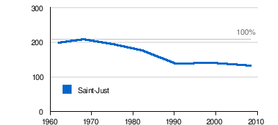
|
||
| 1962 | 197 | |||
| 1968 | 207 | |||
| 1975 | 194 | |||
| 1982 | 175 | |||
| 1990 | 138 | |||
| 1999 | 139 | |||
| 2008 | 131 | |||
| 2016 | 131 | |||
Source: INSEE
The population in the municipality of Saint-Just is generally declining. The decline was much more pronounced than in the rest of the canton of Montagrier.
Attractions

- Saint-Just Church
- Château de Narbonne from the 16th century, the donjon is a monument historique
- 16th century manor of Saint-Just
Infrastructure
Transport links
The center of Saint-Just is on the D 2 from Périgueux to La Tour-Blanche. From here the D 102 branches off to the southwest to Grand-Brassac and Montagrier . The D 106, a right fork of D 102, leads to the disease along by Chapdeuil and continue towards Verteillac or Bertric-Burée .