
Saint-Martin-l'Astier
|
Saint-Martin-l'Astier Sent Martin l'Astier |
||
|---|---|---|

|
|
|
| region | Nouvelle-Aquitaine | |
| Department | Dordogne | |
| Arrondissement | Périgueux | |
| Canton | Vallée de l'Isle | |
| Community association | Isle et Crempse en Périgord | |
| Coordinates | 45 ° 3 ′ N , 0 ° 20 ′ E | |
| height | 39-147 m | |
| surface | 9.4 km 2 | |
| Residents | 138 (January 1, 2017) | |
| Population density | 15 inhabitants / km 2 | |
| Post Code | 24400 | |
| INSEE code | 24457 | |
| Website | http://www.saintmartinlastier.com/ | |
 Town hall (Mairie) of Saint-Martin-l'Astier |
||

Saint-Martin-l'Astier ( Occitan : Sent Martin l'Astier ) is a commune in the region Nouvelle-Aquitaine (before 2016: Aquitaine ) with 138 inhabitants (as of January 1 2017). It is located in the Dordogne department . The municipality is part of the canton of Vallée de l'Isle (until 2015: canton of Mussidan ) in the Arrondissement of Périgueux . The inhabitants are called Saint-Martinois .
geography
Saint-Martin-l'Astier is located in the Périgord Blanc (White Périgord) on the north bank of the Isle . Saint-Martin-l'Astier is surrounded by the neighboring communities of Saint-Étienne-de-Puycorbier in the north, Saint-Front-de-Pardoux in the east, Saint-Médard-de-Mussidan in the south, and Saint-Laurent-des-Hommes in the West and Saint-Michel-de-Double in the north-west.
Population development
| year | 1962 | 1968 | 1975 | 1982 | 1990 | 1999 | 2006 | 2013 |
| Residents | 119 | 128 | 120 | 140 | 152 | 137 | 243 | 137 |
| Source: Cassini and INSEE | ||||||||
Attractions
- Saint-Martin church, bell tower from the 9th century
- 19th century mansion La Roche
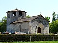
Saint Martin Church

La Roche mansion
.JPG)
