
Manzac-sur-Vern
|
Manzac-sur-Vern Manzac de Vern |
||
|---|---|---|
|
||
| region | Nouvelle-Aquitaine | |
| Department | Dordogne | |
| Arrondissement | Périgueux | |
| Canton | Saint-Astier | |
| Community association | Le Grand Périgueux | |
| Coordinates | 45 ° 5 ' N , 0 ° 35' E | |
| height | 81-214 m | |
| surface | 19.96 km 2 | |
| Residents | 593 (January 1, 2017) | |
| Population density | 30 inhabitants / km 2 | |
| Post Code | 24110 | |
| INSEE code | 24251 | |
 Town hall (Mairie) of Manzac-sur-Vern |
||

Manzac-sur-Vern ( Occitan : Manzac de Vern ) is a French municipality with 593 inhabitants (as of January 1 2017) in the department of Dordogne in the region Nouvelle-Aquitaine ; it belongs to the Arrondissement of Périgueux and the canton of Saint-Astier . The inhabitants are called Manzacois .
geography
Manzac-sur-Vern is located about 15 kilometers southwest of Périgueux in the Périgord am Vern landscape . The neighboring municipalities of Manzac-sur-Vern are Montrem in the north, Coursac in the northeast, Saint-Paul-de-Serre in the east, Bourrou in the south, Jaure in the southwest and Grignols in the west.
Population development
| year | 1962 | 1968 | 1975 | 1982 | 1990 | 1999 | 2006 | 2013 |
| Residents | 437 | 401 | 420 | 417 | 488 | 505 | 509 | 586 |
| Source: Cassini and INSEE | ||||||||
Attractions
- Saint-Pierre-ès-Liens church from the 15th century with a portal from the 12th century
- Rectory
- Leyzarnie Castle, rebuilt at the beginning of the 20th century, monument historique since 2008
- Tower of the former Le Châtenet castle
- Charterhouse of La Couture
- Charterhouse of La Faye
- 17th century mansion dives

Saint-Pierre-ès-Liens church
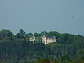
Leyzarnie Castle

Charterhouse of La Couture

Manor Dives


Web links
Commons : Manzac-sur-Vern - collection of images, videos and audio files