
Saint-Victor (Dordogne)
|
Saint-Victor Sent Victor |
||
|---|---|---|
|
||
| region | Nouvelle-Aquitaine | |
| Department | Dordogne | |
| Arrondissement | Périgueux | |
| Canton | Brantôme | |
| Community association | Pays Ribéracois | |
| Coordinates | 45 ° 16 ' N , 0 ° 26' E | |
| height | 63-167 m | |
| surface | 5.12 km 2 | |
| Residents | 203 (January 1, 2017) | |
| Population density | 40 inhabitants / km 2 | |
| Post Code | 24350 | |
| INSEE code | 24508 | |
| Website | http://www.stvictor.fr/ | |
_mairie.JPG) Town hall (Mairie) of Saint-Victor |
||

The French municipality Saint-Victor ( Occitan : Sent Victor ) is in the northwest of the department Dordogne in the region Nouvelle-Aquitaine (before 2016: Aquitaine ). It has 203 inhabitants (as of January 1, 2017) and belongs to the canton of Brantôme (until 2015: canton of Montagrier ). The inhabitants are called Saint-Victoriens .
geography
Saint-Victor is located about 30 kilometers northwest of Périgueux . The Dronne limits the community in the south. Saint-Victor is surrounded by the neighboring communities of Grand-Brasse in the north and north-east, Montagrier in the east, Tocane-Saint-Apre in the south-east, Douchapt in the south, Saint-Méard-de-Drône in the west and south-west and Celles in the west and north-west.
Population development
| year | 1962 | 1968 | 1975 | 1982 | 1990 | 1999 | 2006 | 2013 |
| Residents | 145 | 145 | 137 | 124 | 134 | 157 | 190 | 210 |
| Source: Cassini and INSEE | ||||||||
Attractions
- Saint-Victor church from the 12th century
- Chantemerle Mill
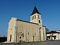
Saint-Victor church
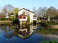
Chantemerle Mill
_%C3%A9glise_(1).JPG)
_moulin_Chantemerle_amont_(1).JPG)