
Clermont-de-Beauregard
| Clermont-de-Beauregard | ||
|---|---|---|
|
||
| region | Nouvelle-Aquitaine | |
| Department | Dordogne | |
| Arrondissement | Périgueux | |
| Canton | Périgord Central | |
| Community association | Isle et Crempse en Périgord | |
| Coordinates | 44 ° 57 ' N , 0 ° 38' E | |
| height | 75-164 m | |
| surface | 6.24 km 2 | |
| Residents | 105 (January 1, 2017) | |
| Population density | 17 inhabitants / km 2 | |
| Post Code | 24140 | |
| INSEE code | 24123 | |
.JPG) View of the center of Clermont-de-Beauregard |
||

Clermont-de-Beauregard is a French municipality with 105 inhabitants (at January 1, 2017) in the department of Dordogne in the region Nouvelle-Aquitaine (before 2016: Aquitaine ). The municipality belongs to the Arrondissement of Périgueux (until 2016: Bergerac ) and the canton of Périgord Central (until 2015: Canton of Villamblard ).
The name in the Occitan language is Clarmont de Beuregard and means "mountain from which one can see clearly" and indicates its geographical location on a hill between two river valleys.
geography
Clermont-de-Beauregard is about 25 km southwest of Périgueux and about 15 km northwest of Bergerac in the historic province of Périgord .
Clermont-de-Beauregard is surrounded by the neighboring municipalities:
| Saint-Martin-des-Combes | Fouleix | |
.svg)
|
||
| Saint-Georges-de-Montclard | Saint-Félix-de-Villadeix |
Clermont-de-Beauregard lies in the catchment area of the Dordogne river . One of its tributaries, the Caudeau , with its tributaries, the Ruisseau les Carbonnières and the Ruchelle, crosses the territory of the commune.
history
During the Hundred Years' War , the fortified site was of extremely strategic importance due to its geographical location and, depending on the course of the war, was owned by the English or French crowns.
At the beginning of the French Revolution , the former municipality of Saint Florent was incorporated into the municipality of Clermont-de-Beauregard.
Toponymy
Toponyms and mentions of Clermont-de-Beauregard were:
- Castrum de Claro Monte (1158, Collection de l'abbé de Lespine ),
- Clarmon , Clermon and Clairmon (16th century, Bergerac Archives),
- Clermont (1750 map by Cassini ),
- Clermont Beauregard (1793, Notice Communale ),
- Clermont-de-Beauregard (1801, Bulletin des Lois ).
Population development
After records began, the population rose to a peak of around 400 in the first half of the 19th century. In the following period, the size of the community fell to around 100 inhabitants during short recovery phases until the 1960s, before a brief growth phase set in. which raised the number of residents to a relative high of around 130. Recently, a phase of stagnation has set in.
| year | 1962 | 1968 | 1975 | 1982 | 1990 | 1999 | 2006 | 2010 | 2017 |
|---|---|---|---|---|---|---|---|---|---|
| Residents | 109 | 102 | 112 | 128 | 123 | 123 | 115 | 142 | 105 |

Attractions
.JPG)
Parish Church of Saint-Front
The church consecrated to the Fronto of Périgueux is located in the center of Clermont-de-Beauregard. It is a new building from the 19th century financed by the Pavillon de la Gaubertie family. It has a plan in the form of a Latin cross . Her style is neo-Gothic and neo-Romanesque at the same time . The church is oriented to the west .
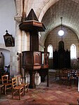
pulpit

Main nave with a view of the choir
.JPG)
.JPG)
Clermont Castle
.JPG)
|
.JPG)
|
|
|
Clermont Castle
|
Former corner tower
|
It has fallen into extensive disrepair and has only kept a few modernized residential wings, part of a Romanesque donjon and above all a high corner tower with a statue of the Madonna at its top from its glamorous past . In 1301, the French King Philip IV exchanged the castle with Elie de Talleyrand. Over the centuries it changed hands and co-owners frequently. It is privately owned and not open to the public.
Economy and Infrastructure
Trade and services are the main economic drivers of the community.

total = 16
traffic
Clermont-de-Beauregard is crossed by Route départementale 21.
Web links
Individual evidence
- ↑ Le nom occitan des communes du Périgord ( fr ) Départementrat des Dordogne. Retrieved October 15, 2018.
- ↑ Ma commune: Clermont-de-Beauregard ( fr ) Système d'Information sur l'Eau du Bassin Adour Garonne. Retrieved October 15, 2018.
- ^ Clermont-de-Beauregard ( fr ) Conseil régional d'Aquitaine. Archived from the original on September 9, 2016. Retrieved October 15, 2018.
- ↑ a b Notice Communale Clermont-de-Beauregard ( fr ) EHESS . Retrieved October 15, 2018.
- ^ Paul Vicomte de Gourgues: Dictionnaire topographique du département de la Dordogne ( fr ) In: Dictionnaire topographique de la France . Imprimerie nationale. P. 78, 1873. Retrieved October 15, 2018.
- ^ France 1750 ( en ) David Rumsey Map Collection: Cartography Associates. Retrieved October 15, 2018.
- ↑ Populations légales 2015 Commune de Clermont-de-Beauregard (24123) ( fr ) INSEE . Retrieved October 15, 2018.
- ↑ Clermont de beauregard ( fr ) Vallée de l'Isle en Périgord tourist office. Retrieved October 15, 2018.
- ↑ Château de Clermont de Beauregard ( fr ) chateau-fort-manoir-chateau.eu. Retrieved October 15, 2018.
- ↑ Caractéristiques des établissements en 2015 Commune de Clermont-de-Beauregard (24123) ( fr ) INSEE . Retrieved October 15, 2018.