
Jaure
| Jaure | ||
|---|---|---|
|
||
| region | Nouvelle-Aquitaine | |
| Department | Dordogne | |
| Arrondissement | Périgueux | |
| Canton | Saint-Astier | |
| Community association | Isle Vern Salembre en Périgord | |
| Coordinates | 45 ° 3 ' N , 0 ° 33' E | |
| height | 93-221 m | |
| surface | 7.54 km 2 | |
| Residents | 170 (January 1, 2017) | |
| Population density | 23 inhabitants / km 2 | |
| Post Code | 24140 | |
| INSEE code | 24213 | |
 City Hall (Mairie) of Jaure |
||

Jaure is a French municipality with 170 inhabitants (as of January 1 2017) in the department of Dordogne in the region Nouvelle-Aquitaine ; it belongs to the Arrondissement of Périgueux and the canton of Saint-Astier . The inhabitants are called Jaurands .
geography
Jaure is located about 19 kilometers southwest of Périgueux in the Périgord countryside on the small river Jaurès . The neighboring municipalities of Jaure are Grignols in the north and northwest, Mazac-sur-Vern in the northeast, Bourrou in the east and southeast and Villamblard in the south and west.
Population development
| year | 1962 | 1968 | 1975 | 1982 | 1990 | 1999 | 2006 | 2012 |
| Residents | 160 | 140 | 124 | 158 | 143 | 140 | 150 | 155 |
| Source: Cassini and INSEE | ||||||||
Attractions
- Megaliths La Fontrouge and Les Rocs
- Saint-Firmin church from the 12th century, a historic monument since 1984
- Jaure Castle with a pigeon tower from the 15th century
- Saint-Firmin fountain and wash-house

Saint-Firmin church

Jaure Castle
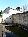
Saint-Firmin fountain
.JPG)
.JPG)

Web links
Commons : Jaure - collection of images, videos and audio files