
Gout-Rossignol
|
Gout-Rossignol Gots e Rossinhòu |
||
|---|---|---|
|
||
| region | Nouvelle-Aquitaine | |
| Department | Dordogne | |
| Arrondissement | Périgueux | |
| Canton | Ribérac | |
| Community association | Pays Ribéracois | |
| Coordinates | 45 ° 25 ' N , 0 ° 23' E | |
| height | 104-185 m | |
| surface | 24.91 km 2 | |
| Residents | 379 (January 1, 2017) | |
| Population density | 15 inhabitants / km 2 | |
| Post Code | 24320 | |
| INSEE code | 24199 | |
 Town hall (Mairie) by Gout-Rossignol |
||

Gout-Rossignol (also Goûts-Rossignol ; Occitan : Gots e Rossinhòu a) community with 379 inhabitants (as of January 1 2017) in the southern French department of Dordogne in the region Nouvelle-Aquitaine (before 2016: Aquitaine ). The municipality belongs to the Arrondissement of Périgueux and the canton of Ribérac (until 2015: canton Distriblac ).
location
Gout-Rossignol is about 37 kilometers northwest of Périgueux . Gout-Rossignol is surrounded by the neighboring communities of La Rochebeaucourt-et-Argentine in the north and north-west, Sainte-Croix-de-Mareuil in the north, Mareuil in the east and north-east, La Chapelle-Montabourlet in the east and south-east, La Tour-Blanche in the south-east , Cherval in the south and Champagne-et-Fontaine in the west.
Population development
| year | 1962 | 1968 | 1975 | 1982 | 1990 | 1999 | 2006 | 2013 |
| Residents | 460 | 481 | 442 | 444 | 463 | 429 | 416 | 387 |
| Source: Cassini and INSEE | ||||||||
Attractions
- Church of Saint-Pierre-ès-Liens in Rossignol from the 12th century, renovations from the 14th century, monument historique since 2011
- Saint-Étienne church, rebuilt in the 19th century
- Jaurias Castle from the 18th / 19th centuries century
- La Vassaldie castle from the 18th century, monument historique
- 18th century mansion of Bouillaguet
- Mitonias mansion from the 18th century
- Soulet Mill

Saint-Pierre-ès-Liens church

Saint-Etienne church
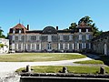
La Vassaldie Castle


.JPG)