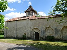
La Jemaye-Ponteyraud
| La Jemaye-Ponteyraud | ||
|---|---|---|
|
|
||
| region | Nouvelle-Aquitaine | |
| Department | Dordogne | |
| Arrondissement | Périgueux | |
| Canton | Ribérac | |
| Community association | Pays Ribéracois | |
| Coordinates | 45 ° 10 ′ N , 0 ° 15 ′ E | |
| height | 49-131 m | |
| surface | 33.31 km 2 | |
| Residents | 154 (January 1, 2017) | |
| Population density | 5 inhabitants / km 2 | |
| Post Code | 24410 | |
| INSEE code | 24216 | |
La Jemaye-Ponteyraud is a French municipality with 154 inhabitants (as of January 1 2017) in the Dordogne in the region Nouvelle-Aquitaine . It belongs to the Arrondissement of Périgueux and the Canton of Ribérac .
It was created with effect from January 1, 2017 as Commune nouvelle by amalgamating the previously independent municipalities of La Jemaye and Ponteyraud , which have the status of a Commune déléguée in the new municipality . The administrative headquarters are located in La Jemaye.
structure
| District | former INSEE code |
Area (km²) | Population as of January 1, 2017 |
|---|---|---|---|
| La Jemaye (administrative headquarters) | 24216 | 29.12 | 111 |
| Ponteyraud | 24333 | 4.19 | 43 |
location
Neighboring municipalities are Saint-Vincent-Jalmoutiers in the northwest, Saint Privat en Périgord in the north, Vanxains in the northeast, Siorac-de-Ribérac in the east, Saint-André-de-Double in the southeast, Saint-Michel-de-Double in the south and Échourgnac in the southwest.
Web links
Individual evidence
- ↑ adoption PREF / DDL / 2016/0282 of the prefecture on the formation of the commune of La nouvelle Jemaye-Ponteyraud from 01/12/2016
- ↑ current population according to INSEE

