
Douville
|
Douville Dovila |
||
|---|---|---|

|
|
|
| region | Nouvelle-Aquitaine | |
| Department | Dordogne | |
| Arrondissement | Périgueux | |
| Canton | Périgord Central | |
| Community association | Isle et Crempse en Périgord | |
| Coordinates | 45 ° 0 ′ N , 0 ° 35 ′ E | |
| height | 110-233 m | |
| surface | 19.91 km 2 | |
| Residents | 451 (January 1, 2017) | |
| Population density | 23 inhabitants / km 2 | |
| Post Code | 24140 | |
| INSEE code | 24155 | |
| Website | Douville | |
 Douville - town view with Église Saint-Front |
||

Douville ( Occitan Dovila ) is a French city and a municipality (commune) , with 451 inhabitants (as of January 1 2017) in the department of Dordogne in the region Nouvelle-Aquitaine . The community consists of the main town as well as some hamlets (hameaux) and individual farms (fermes) .
Location and climate
The place Douville lies in the cultural landscape of the Périgord at an altitude of about 135 m ; Le Pont Saint-Mamet , a district about 2 km to the south, extends along the banks of the Crempse . The city of Périgueux is a good 28 km (driving distance) to the north-east; the city of Bergerac is a good 21 km southwest. The climate is temperate; Rain (approx. 835 mm / year) falls over the year.
Population development
| year | 1800 | 1851 | 1901 | 1954 | 1999 | 2015 |
| Residents | 772 | 1,001 | 762 | 385 | 401 | 452 |
The continuous decline in population in the first half of the 20th century is mainly due to the mechanization of agriculture and the abandonment of small farms. Since the 1980s there has been a slight population growth again.
economy
Residents of the community lived for centuries as self by the Agriculture and Forestry (cereals, charcoal); Fruit and vegetables were grown in the hotel's own gardens. Small traders and craftsmen have settled in the village.
history
The first mentions of the place name Douvilla or Dosvila come from the 13th and 15th centuries; however, the church was not built until the 16th century. In 1794, the previously independent communities of Douville and Le Pont-Saint-Mamet merged.
Attractions
- Douville
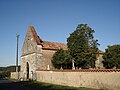
- The Église Saint-Front dates from the 16th century. The rather unadorned church has a flat closed apse and a triangular bell gable (clocher mur) in the west.
- The Château de Roussille , already mentioned in the 8th century, changed hands repeatedly in the Middle Ages, but especially during the Hundred Years War (1337-1453). It was destroyed during the French Revolution .
- Le Pont Saint-Mamet
- In the cemetery of the hamlet of Le Pont Saint-Mamet is the also dating from the 16th century and the legendary Holy Mamas consecrated Église Saint Mamet . It also has a flat-closing apse and a triangular bell gable.
- The Château de la Forge , built in the 17th century, is a two-story building with a hatch-roof . It now serves as a hotel.
- The Château de Saint-Mamet dates from the 18th century. It is privately owned.
- The Château de Lestaubiere was built in the 19th century and is now a hotel.

Église Saint-Front

Nave
Église Saint Mamet

Nave
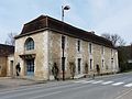
Town hall (mairie)
.JPG)


Web links
- Douville - Photos + Info (French)