
Montrem
|
Montrem Montrenc |
||
|---|---|---|
|
||
| region | Nouvelle-Aquitaine | |
| Department | Dordogne | |
| Arrondissement | Périgueux | |
| Canton | Saint-Astier | |
| Community association | Isle Vern Salembre en Périgord | |
| Coordinates | 45 ° 9 ′ N , 0 ° 34 ′ E | |
| height | 65-217 m | |
| surface | 20.15 km 2 | |
| Residents | 1,250 (January 1, 2017) | |
| Population density | 62 inhabitants / km 2 | |
| Post Code | 24110 | |
| INSEE code | 24295 | |
| Website | http://www.mairie-montrem.fr/ | |
 Town hall (Mairie) of Montrem |
||

Montrem ( Occitan : Montrenc ) is a French municipality with 1,250 inhabitants (as of January 1 2017) in the department of Dordogne in the region Nouvelle-Aquitaine ; it belongs to the Arrondissement of Périgueux and the canton of Saint-Astier .
geography
Montrem is located about eleven kilometers west-southwest of Périgueux in the Périgord countryside . The Isle limits the community to the north. The neighboring municipalities of Montrem are Annesse-et-Beaulieu in the north, Razac-sur-l'Isle in the northeast, Coursac in the east, Manzac-sur-Vern in the south, Grignols in the southwest and Saint-Astier in the west.
The A89 autoroute runs through the municipality .
Population development
| year | 1962 | 1968 | 1975 | 1982 | 1990 | 1999 | 2006 | 2013 |
| Residents | 858 | 770 | 913 | 982 | 1,045 | 1,049 | 1,195 | 1,262 |
| Source: Cassini and INSEE | ||||||||
Attractions
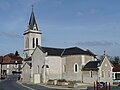
- Saint-Pierre-ès-Liens church in Montrem from the 12th century, monument historique since 1948
- Notre-Dame church in Montanceix from the 19th century

Saint-Pierre-ès-Liens church
Notre-Dame church
.JPG)

Web links
Commons : Montrem - collection of images, videos and audio files