
Champagne-et-Fontaine
|
Champagne-et-Fontaine Champanha e Fontanas |
||
|---|---|---|
|
||
| region | Nouvelle-Aquitaine | |
| Department | Dordogne | |
| Arrondissement | Périgueux | |
| Canton | Ribérac | |
| Community association | Pays Ribéracois | |
| Coordinates | 45 ° 25 ′ N , 0 ° 19 ′ E | |
| height | 77-169 m | |
| surface | 25.04 km 2 | |
| Residents | 387 (January 1, 2017) | |
| Population density | 15 inhabitants / km 2 | |
| Post Code | 24320 | |
| INSEE code | 24097 | |
| Website | http://www.champagne-et-fontaines.fr/ | |
 Town hall (Mairie) of Champagne-et-Fontaine |
||

Champagne-et-Fontaine ( Occitan : Champanha e Fontana ) is a municipality with 387 inhabitants (as of January 1 2017) in the southern French department of Dordogne in the region Nouvelle-Aquitaine (before 2016: Aquitaine ). The municipality belongs to the Arrondissement of Périgueux and the canton of Ribérac (until 2015: canton Distriblac ). The inhabitants are called Champenois-et-Fontenois .
location
Champagne-et-Fontaine is about 41 kilometers northwest of Périgueux . Champagne-et-Fontaine is surrounded by the neighboring communities of Blanzaguet-Saint-Cybard in the north, La Rochebeaucourt-et-Argentine in the northeast, Gout-Rossignol in the east, Cherval in the southeast, La Chapelle-Grésignac in the south, Nanteuil-Auriac-de- Bourzac in the southwest, Vendoire in the west and Gurat in the northwest.
Population development
| year | 1962 | 1968 | 1975 | 1982 | 1990 | 1999 | 2006 | 2013 |
| Residents | 655 | 600 | 511 | 477 | 415 | 431 | 412 | 405 |
| Source: Cassini and INSEE | ||||||||
Attractions
- Saint-Martin church from the 12th / 13th centuries Century, renovations from later times, Monument historique since 1947
- Saint-Jean-Baptiste church from the 12th century with renovations from the 15th century, monument historique since 1948
- Clauzuroux castle from the 17th century, monument historique since 1947
- La Richardie Castle from the 17th century
- Chaumont Castle from 1667
- La Ligerie Castle
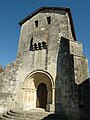
Saint Martin Church

Saint-Jean-Baptiste church

Clauzuroux Castle

Chaumont Castle


