La Chapelle-Grésignac
|
La Chapelle-Grésignac La Chapela de Gresinhac |
||
|---|---|---|
|
|
||
| region | Nouvelle-Aquitaine | |
| Department | Dordogne | |
| Arrondissement | Périgueux | |
| Canton | Ribérac | |
| Community association | Pays Ribéracois | |
| Coordinates | 45 ° 24 ' N , 0 ° 20' E | |
| height | 78-174 m | |
| surface | 6.95 km 2 | |
| Residents | 108 (January 1, 2017) | |
| Population density | 16 inhabitants / km 2 | |
| Post Code | 24320 | |
| INSEE code | 24109 | |
| Website | La Chapelle-Grésignac | |
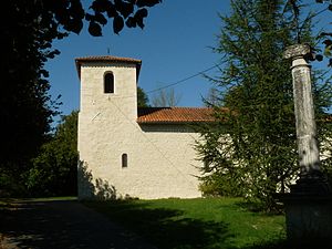
 La Chapelle-Grésignac - Église Saint-Étienne |
||
La Chapelle-Grésignac ( Occitan La Chapela de Gresinhac ) is a French commune (commune) with 108 inhabitants (as of January 1 2017) in the department of Dordogne in the region Nouvelle-Aquitaine . The community consists of the two main places La Chapelle and Grésignac as well as two hamlets (hameaux) and some individual farms (fermes) .
Location and climate
The twin town of La Chapelle-Grésignac is located in the cultural landscape of the Périgord near the border with the Angoumois at an altitude of approx. 110 m . The city of Périgueux is a good 45 km (driving distance) in a south-easterly direction; the city of Angoulême is a good 38 km northwest. The climate is temperate; Rain (approx. 900 mm / year) falls over the year.
Population development
| year | 1800 | 1851 | 1901 | 1954 | 1999 | 2015 |
| Residents | 419 | 411 | 305 | 216 | 112 | 107 |
The continuous decline in population in the late 19th and 20th centuries is essentially due to the mechanization of agriculture and the abandonment of small farms.
economy
Residents of the community lived for centuries as self by the Agriculture and Forestry (cereals, charcoal); Fruit and vegetables were grown in the hotel's own gardens. Small traders and craftsmen have settled in the village.
history
The first mentions of the place name Greziniaco or Grezinhaco come from the 13th and 14th centuries; at that time Grézignac was still closely associated with the Angoumois. The town's Romanesque church was built in the 12th century. The district of La Chapelle belonged to Grézignac for a long time.
Attractions
- La Chapelle
- The single-aisle Église Saint-Étienne , which was formerly part of Grézignac and later part of Aubeterre-sur-Dronne and was rebuilt in the 17th century, was thoroughly restored in the 19th century. The nave is spanned by a wooden vault. The church building has been classified as a monument historique since 2000 .
- Grézignac
- The oldest evidence of the history of Grézignac, which used to be closely connected to the Angoumois, is a mound of earth that was raised by human hands and on which a wooden fortress ( moth ) once stood. The hill has also been recognized as a monument historique since 2000 .
- The former parish church of Saint-Jean still existed in the 17th century; after that, her condition became increasingly dilapidated. In 1902 two segments of the barrel vault were still visible. The church ruin has also been recognized as a monument historique since 2000 .
- Clauzurou
The Château du Clauzurou, which is close to the northern municipal boundary, and a neighboring watermill are both on the territory of the neighboring municipality of Champagne-et-Fontaine .
Web links
Individual evidence
- ↑ La Chapelle-Grésignac - Map with altitude information
- ↑ La Chapelle-Grésignac / Distribution Lac - climate tables
- ↑ La Chapelle - Église Saint-Étienne in the Base Mérimée of the French Ministry of Culture (French)
- ↑ Grézignac - Motte castrale in the Base Mérimée of the French Ministry of Culture (French)
- ↑ Grézignac - Église Saint-Jean in the Base Mérimée (French) of the French Ministry of Culture


