
Grand Brassac
|
Grand Brassac Braçac |
||
|---|---|---|
|
||
| region | Nouvelle-Aquitaine | |
| Department | Dordogne | |
| Arrondissement | Périgueux | |
| Canton | Brantôme | |
| Community association | Pays Ribéracois | |
| Coordinates | 45 ° 18 ′ N , 0 ° 29 ′ E | |
| height | 73-211 m | |
| surface | 31.74 km 2 | |
| Residents | 535 (January 1, 2017) | |
| Population density | 17 inhabitants / km 2 | |
| Post Code | 24350 | |
| INSEE code | 24200 | |
 Town hall (Mairie) of Grand-Brassac |
||

Grand-Brassac ( Occitan Braçac ) is a commune in the northwest of the department Dordogne in the region Nouvelle-Aquitaine (before 2016: Aquitaine ). It has 535 inhabitants (as of January 1, 2017) and belongs to the canton of Brantôme (until 2015: canton of Montagrier ).
geography
Grand-Brassac is located about 22 kilometers northwest of Périgueux (as the crow flies) on the Dronne and the Euche . Grand-Brassac is surrounded by the neighboring communities of Chapdeuil and Saint-Just in the north, Paussac-et-Saint-Vivien in the northeast, Creyssac and Bourdeilles in the east, Lisle in the east and southeast, Montagrier in the south, Saint-Victor in the southwest, Celles in the West and Bourg-des-Maisons in the northwest.
Population development
| year | 1962 | 1968 | 1975 | 1982 | 1990 | 1999 | 2006 | 2013 |
| Residents | 814 | 676 | 609 | 528 | 488 | 489 | 531 | 528 |
| Source: Cassini and INSEE | ||||||||
Attractions
- Saint-Pierre-et-Saint-Paul church from the 12th century, alterations from the 16th century, monument historique since 1885
- Former convent of the Sisters of the Congregation of Saint Joseph from the 16th century, alterations until the 18th century
- prehistoric caves of Rochereuil, monument historique since 1952
- Le Bouchillon Castle from the 19th century
- Marouatte castle from the 13th century, renovations from the 19th century
- Montardy Castle from the 14th century, alterations from the 18th / 19th century. Century, since 2001 Monument historique
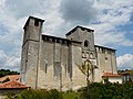
Saint-Pierre-et-Saint-Paul church

Congregation of Sisters of Saint Joseph

Rochebreuil Caves
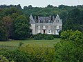
Le Bouchillon Castle
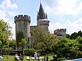
Marouatte Castle

Montardy Castle
.jpg)
.JPG)


.jpg)
Web links