
Lusignac
|
Lusignac Lusinhac |
||
|---|---|---|
|
||
| region | Nouvelle-Aquitaine | |
| Department | Dordogne | |
| Arrondissement | Périgueux | |
| Canton | Ribérac | |
| Community association | Communes du Pays Ribéracois | |
| Coordinates | 45 ° 20 ′ N , 0 ° 19 ′ E | |
| height | 62-184 m | |
| surface | 7.88 km 2 | |
| Residents | 180 (January 1, 2017) | |
| Population density | 23 inhabitants / km 2 | |
| Post Code | 24320 | |
| INSEE code | 24247 | |
 Lusignac Town Hall |
||

Lusignac is a French commune of 180 inhabitants (at January 1, 2017) in the department of Dordogne in the region Nouvelle-Aquitaine (before 2016: Aquitaine ). The municipality belongs to the Arrondissement of Périgueux and the canton of Ribérac (until 2015: canton Distriblac ).
The name in the Occitan language is Lusinhac . which goes back to the name of a country estate in Gallo-Roman times that belonged to a "Lucinius" or "Licinius".
The inhabitants are called Lusignacois and Lusignacoises .
geography
Lusignac is located about 35 km northwest of Périgueux in the Ribéracois area of the historic province of Périgord on the western edge of the department.
Lusignac is surrounded by the neighboring communities:
| Bouteilles-Saint-Sébastien | Saint-Martial-Viveyrol | Distribution |
| Saint-Paul-Lizonne |
.svg)
|
Bertric-Burée |
| Allemans |
Lusignac lies in the catchment area of the Dordogne river . Tributaries of the Lizonne , the Cendronne and the Sauvanie, cross the territory of the commune.
history
The center of today's parish developed on a plateau around the parish church, which was built in the 12th century. Since the 15th century, a castle has protected the population of the village and the hamlets, most of which extend on slopes. Lusignac was formerly a noble seat and in 1760 the seat of a Justice haute (high court).
Toponymy
Toponyms and mentions of Lusignac were:
- Luginhacum (13th century, church register),
- Luginhac (16th century, castellany of Périgord, Pau archives ),
- Luziniat (1760, Document on the State of Jurisprudence in the Guyenne ),
- Lusinhac (1750, map by Cassini ),
- Luzinhac (1793, Notice Communale ),
- Lusinhac (1801, Bulletin des Lois ).
Population development
After records began, the population rose to a peak of around 500 in the middle of the 19th century. In the following years, the size of the community fell to a level of around 190 inhabitants until the 1980s, which is still held today.
| year | 1962 | 1968 | 1975 | 1982 | 1990 | 1999 | 2006 | 2010 | 2017 |
|---|---|---|---|---|---|---|---|---|---|
| Residents | 239 | 210 | 201 | 192 | 192 | 185 | 181 | 189 | 180 |


Town twinning
Lusignac maintains over the former Canton Verteillac since 1988 a twinning with Fontanetto Po in the Italian region of Piedmont .
Attractions

Parish Church of Saint-Eutrope
The church was built in two steps. In the early 12th century, the flat was completed choir and three yokes of with domes covered longhouse built. At the end of the 12th century, the two western bays of the nave were provided with a barrel vault . After being destroyed in the Huguenot Wars , the choir was restored in the 16th century, but retained its barrel vault. The three yokes of the single-nave nave, on the other hand, were equipped with a ribbed vault at the same time . Repairs were made to the outside in the 19th century. One of the northern buttresses bears the year "1946". The Romanesque bell tower with its tent roof rises above the first and one half of the second bay of the nave. The southwest facade is occupied by a weir bay window , which is decorated with keel arches from the 16th century. It rests on consoles that are reminiscent of machiculi . A small vestibule has been added to the bell tower, while on the opposite side a deep well from the time the church was built was built on the apse between the corner buttresses and the sacristy . Broken walls in the building's exterior testify to the repairs made over the centuries. Inside the church there are two piscines under a pressed pointed arch on the south wall. The church has been inscribed as a Monument historique since December 17, 1947 .
Two elements of the interior have been classified as movable objects as Monuments historiques since February 17, 1971 . A stone sculpture depicting the Pietà was created at the end of the 15th century. It is damaged because the legs of Christ and the hands of Mary are missing today. The pastor of Lusignac found the 43 cm high work in the bell tower in the second half of the 19th century. Before 1898 it was installed in the rectory garden before it found its place in the church in the 20th century. A stone built into the buttress and the apse bore the inscription "MA TU IN DIE TRIBULATIONIS SPES MEA" together with a Christ monogram and the year "1641". This is related to a plague epidemic , the end of which was attributed to the intercession to the Pietà.
The second work is a tabernacle from the 17th century. It is made of walnut wood and measures 160 cm in height and 210 cm in width. Six rotated columns structure the shrine with two side wings and two levels. It is embellished by numerous panels with bas-reliefs , two statuettes in niches and two busts in half-relief and crowned with a ribbed dome. The good shepherd is depicted as a bas-relief on the door . The two statuettes show Saint Roch of Montpellier and Saint Fronto of Périgueux . The biblical scenes of the Annunciation and the Visitation of Mary are illustrated on medallions . The two busts on the side wings show Christ and Mary. On the upper level, side panels depict two scenes of the Passion , Christ Carrying the Cross and Christ's Agony .

Southwest facade

Fountain
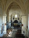
Nave overlooking the choir

View from the gallery


Castle

The noble de la Porte family originally owned a castle in Lusignac in the 13th century. The current castle was built in the 15th century and belonged to the Brianson family until 1654, then again to the Seigneurs de la Porte and von Lusignac. In 1714 the castle came into the possession of Pierre de Lageard, Seigneur and Comte von Cherval , Grand Seneschal of the Angoumois , whose family subsequently kept the lands until 1855. The structure suffered damage during the French Revolution . So the battlements on the curtains have disappeared. In 1880 a fire destroyed the north flank, which was then replaced by an extension of the castle wall. Based on a castle wall with a rectangular floor plan and four towers at the corners, today's castle consists of a residential wing from the 15th century. This is built from ashlar and quarry stone from limestone . Its windows and doors were probably enlarged at the end of the 16th century. Window posts and bars were made of wood. A polygonal tower is fitted with a conical roof , which is covered with flat tiles. A long curtain wall forms the southern flank and connects two square towers, which were undoubtedly intended as living rooms, as they are provided with twin windows. They also have loopholes , which are arranged both on the window parapets and on the sides. In the southwest the entrance portal is provided with a large restored weir bay window. The year "1665" can be seen above the entrance. The pedestrian door below is accessible by stairs. The renaissance gate to the inner courtyard is provided with boss work . It was damaged during the Revolution and undoubtedly bore the coat of arms of the La Porte family, which was shattered during that period

Village center
In the center of Lusignac, houses from the 17th and 18th centuries have been preserved and no modern buildings have been constructed. That is why it has been inscribed as a Monument historique since August 20, 1974 .
Viger water mill
Since the watermill is marked on the maps of Pierre de Belleyme and Cassini , it has existed at least since the second half of the 18th century. According to local traditions, the mill was already used during the reign of the French King Louis XIII. (1610 to 1643), and the Mühlbach was dug by English prisoners after the siege of La Rochelle (1627-1628) . It was probably equipped with horizontal wooden water wheels , which were replaced with more powerful metal wheels at the end of the 19th century. At the same time the mill was completely overhauled. The Napoleonic land register shows that an oil mill was added after 1825 because it had not yet been recorded. According to a data collection in 1936, the flour mill was no longer producing bread flour at that time, because it was discontinued in 1920. The operation focused on the crushing of grain for animal feed. The production of nut oil, on the other hand, lasted until the 1950s. The mill building is located on a weir above a mill stream that branches off from the Sauvanie. It has a rectangular floor plan, two floors with an attic and a saddle roof that is covered with interlocking tiles. The western part of the building and the first floor served as living space. The operation was spread over two rooms in the east. The first, in the middle of the building, hid the moat with the two horizontal water wheels that were connected to the millstones below. The second room was intended for the mill for the production of nut and sunflower oil with an oil press and two millstones that were driven by a horizontal water wheel. Today the mill is privately owned and cannot be visited.
Economy and Infrastructure

Lusignac is located in the AOC zones of the Charentes-Poitou , Charentes and Deux-Sèvres butter varieties , the Périgord walnuts and the Périgord nut oil.

total = 25
traffic
The Route départementale 97 crosses the north the municipality on a short section. It combines Verteillac , the main town of the former Canton, with Bouteilles-Saint-Sébastien and Palluaud in neighboring Charente . The route départementale 97E branches off from this and crosses Lusignac from north to south and connects the municipality with Saint-Séverin in the neighboring department of Charente via Saint-Paul-Lizonne.
Web links
- Information about the Charentes-Poitou butter (French)
- Product sheet for Charentes butter on the INAO website (French)
- Deux-Sèvres butter product sheet on the INAO website (French)
- Périgord nut oil product sheet on the INAO website (French)
- Information on Périgord walnuts (French)
Individual evidence
- ↑ Le nom occitan des communes du Périgord ( fr ) Départementrat des Dordogne. Retrieved November 27, 2018.
- ↑ Dordogne ( fr ) habitants.fr. Retrieved November 27, 2018.
- ↑ Ma commune: Lusignac ( fr ) Système d'Information sur l'Eau du Bassin Adour Garonne. Retrieved November 27, 2018.
- ↑ village ( fr ) Ministry of Culture and Communication . November 13, 2008. Retrieved November 27, 2018.
- ↑ a b Paul Vicomte de Gourgues: Dictionnaire topographique du département de la Dordogne ( fr ) In: Dictionnaire topographique de la France . Imprimerie nationale. S. 182, 1873. Retrieved November 27, 2018.
- ^ France 1750 ( en ) David Rumsey Map Collection: Cartography Associates. Retrieved November 27, 2018.
- ↑ a b Notice Communale Lusignac ( fr ) EHESS . Retrieved November 27, 2018.
- ↑ Populations légales 2015 Commune de Lusignac (24247) ( fr ) INSEE . Retrieved November 27, 2018.
- ^ Jean-Louis Savignac: Les 30 bougies du jumelage franco-Italien ( fr ) Sud Ouest . April 27, 2018. Retrieved November 27, 2018.
- ↑ église paroissiale Saint-Eutrope ( fr ) Ministry of Culture and Communication . November 13, 2008. Retrieved November 27, 2018.
- ^ Eglise Saint-Eutrope ( fr ) Ministry of Culture and Communication . September 22, 2015. Accessed November 27, 2018.
- ↑ groupe sculpté: Vierge de Pitié ( fr ) Ministry of Culture and Communication . October 7, 1993. Retrieved November 27, 2018.
- ↑ tabernacle à ailes et dais d'exposition du maître-autel, et ses statuettes ( fr ) Ministry of Culture and Communication . October 7, 1993. Retrieved November 27, 2018.
- ↑ Château fort de Lusignac ( fr ) Ministry of Culture and Communication . November 13, 2008. Retrieved November 27, 2018.
- ↑ village ( fr ) Ministry of Culture and Communication . November 13, 2008. Retrieved November 27, 2018.
- ↑ moulin à blé, moulin à huile, dit moulin de Vigier ( fr ) Ministry of Culture and Communication . November 13, 2008. Retrieved November 27, 2018.
- ↑ Institut national de l'origine et de la qualité: Rechercher un produit ( fr ) Institut national de l'origine et de la qualité . Retrieved November 27, 2018.
- ↑ Caractéristiques des établissements en 2015 Commune de Lusignac (24247) ( fr ) INSEE . Retrieved November 27, 2018.