
Saint-Pierre-de-Chignac
| Saint-Pierre-de-Chignac | ||
|---|---|---|
.svg)
|
|
|
| region | Nouvelle-Aquitaine | |
| Department | Dordogne | |
| Arrondissement | Périgueux | |
| Canton | Isle Manoire | |
| Community association | Le Grand Périgueux | |
| Coordinates | 45 ° 7 ' N , 0 ° 51' E | |
| height | 126-252 m | |
| surface | 15.7 km 2 | |
| Residents | 871 (January 1, 2017) | |
| Population density | 55 inhabitants / km 2 | |
| Post Code | 24330 | |
| INSEE code | 24484 | |
| Website | http://www.stpierredechignac.notremairie.fr/ | |
 Town hall (Mairie) of Saint-Pierre-de-Chignac |
||

Saint-Pierre-de-Chignac is a French municipality with 871 inhabitants (as of January 1 2017) in the department of Dordogne in the region Nouvelle-Aquitaine . It belongs to the Arrondissement of Périgueux and the canton of Isle-Manoire (until 2015: canton of Saint-Pierre-de-Chignac ).
geography
Saint-Pierre-de-Chignac is located in the Périgord countryside , about twelve kilometers south-east of Périgueux . Neighboring municipalities are: Bassillac et Auberoche in the north, Saint-Crépin-d'Auberoche in the east, Saint-Geyrac in the southeast, La Douze in the south and Boulazac Isle Manoire in the west.
Population development
| year | 1962 | 1968 | 1975 | 1982 | 1990 | 1999 | 2006 | 2013 |
| Residents | 664 | 675 | 654 | 718 | 771 | 777 | 776 | 860 |
| Source: Cassini and INSEE | ||||||||
Attractions
- Saint-Pierre-ès-Liens church
- Lardimalie castle from the 19th century with park, monument historique since 1984
- Les Maillots Castle
- Charterhouse of Fayard
- Museum Chai de Lardimalie, built in 1902, Monument historique

Saint-Pierre-ès-Liens church (Petri chains)
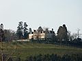
Lardimalie Castle

Les Maillots Castle

Charterhouse of Fayard

.JPG)
.JPG)
.JPG)
Web links
Commons : Saint-Pierre-de-Chignac - Collection of images, videos and audio files