
Chapdeuil
|
Chapdeuil Lu Chapduelh |
||
|---|---|---|
|
||
| region | Nouvelle-Aquitaine | |
| Department | Dordogne | |
| Arrondissement | Périgueux | |
| Canton | Brantôme | |
| Community association | Pays Ribéracois | |
| Coordinates | 45 ° 21 ′ N , 0 ° 29 ′ E | |
| height | 115-186 m | |
| surface | 7.71 km 2 | |
| Residents | 130 (January 1, 2017) | |
| Population density | 17 inhabitants / km 2 | |
| Post Code | 24320 | |
| INSEE code | 24105 | |
| Website | Chapdeuil | |
 Chapdeuil - Château |
||

Chapdeuil ( Occitan Lu Chapduelh ) is a commune of 130 inhabitants (at January 1, 2017) of the northwestern department Dordogne in the region Nouvelle-Aquitaine (before 2016 Aquitaine ). The community consists of the main town as well as some hamlets (hameaux) and individual farms (fermes) .
Location and climate
The place Chapdeuil is located on the river Euche on a tectonically determined bulge in the cultural landscape of the Périgord a good 31 km (driving distance) northwest of Périgueux at an altitude of about 120 m . The city of Bergerac is about 70 km south. The climate is moderate, rain (approx. 875 mm / year) falls over the year.
Population development
| year | 1800 | 1851 | 1901 | 1954 | 1999 | 2015 |
| Residents | 326 | 760 | 266 | 219 | 111 | 130 |
The continuous decline in population in the 20th century is mainly due to the mechanization of agriculture and the abandonment of small farms.
economy
The community is traditionally oriented towards agriculture and forestry; the residents lived on a self-sufficient basis for centuries . Today fish farming and the rental of holiday apartments ( gîtes ) also play important roles in economic life.
history
The first mention of the place under the name Capdolium comes from the year 1143. In the late Middle Ages, the place was the seat of a castellany , which included the parish of Bourg-des-Maisons , Cercles and Distribution .
Attractions
- The Château de Chapdeuil , built in the 15th century, was later expanded to include a residential wing ( logis ) ; the core building has nevertheless retained its medieval appearance with a moat (douves) , drawbridge (pont levis) , keep ( donjon ) and battlement (mâchicoulis) . A round pigeon house (pigeonnier) also belongs to the ensemble, which is privately owned and has been recognized as a monument historique since 1988 .
- The St. Église Saint-Astier , consecrated to Asterius , dates from the end of the 19th century. The church, stabilized on all sides by buttresses , has replaced a previous medieval building.
- There is a house (maison forte) with a polygonal stair tower in the village .
- On the outskirts there is a wash place ( lavoir ) from the 19th century.

Château de Chapdeuil

Pigeon house
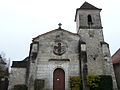
Church Saint-Astier

Maison forte stair tower

-roof-passage (passage)

Washing place (lavoir)
.JPG)
.JPG)

.JPG)
.JPG)
.JPG)
Web links
Individual evidence
- ↑ Chapdeuil - Map with altitude information .
- ↑ Chapdeuil / Ribérac - climate tables
- ↑ Chapdeuil - Château de Chapdeuil in the Base Mérimée of the French Ministry of Culture (French)
- ↑ Chapdeuil - Château