
Lisle (Dordogne)
|
Lisle L'Esla |
||
|---|---|---|

|
|
|
| region | Nouvelle-Aquitaine | |
| Department | Dordogne | |
| Arrondissement | Périgueux | |
| Canton | Brantôme | |
| Community association | Pays Ribéracois | |
| Coordinates | 45 ° 17 ′ N , 0 ° 33 ′ E | |
| height | 76-217 m | |
| surface | 17.97 km 2 | |
| Residents | 859 (January 1, 2017) | |
| Population density | 48 inhabitants / km 2 | |
| Post Code | 24350 | |
| INSEE code | 24243 | |
| Website | http://www.mairie-de-lisle.eu/ | |
.JPG) Look at Lisle |
||

Lisle ( Occitan : L'Esla ) is a French municipality with 859 inhabitants (as of January 1 2017) in the department of Dordogne in the region Nouvelle-Aquitaine ; it belongs to the Arrondissement of Périgueux and the Canton of Brantôme .
geography
Lisle is located about 17 kilometers northwest of Périgueux in the Périgord countryside . The neighboring municipalities of Lisle are Bourdeilles in the north and north-east, Bussac in the east, Mensignac in the south, Tocane-Saint-Apre in the south-west and Grand-Brassac in the west and north-west.
Population development
| year | 1962 | 1968 | 1975 | 1982 | 1990 | 1999 | 2006 | 2013 |
| Residents | 967 | 990 | 934 | 917 | 946 | 909 | 920 | 896 |
| Source: Cassini and INSEE | ||||||||
Attractions
- Saint-Martin church from the 12th century with later alterations, monument historique since 1908/2006
- Upper and lower castle, each from the 16th century
- 19th century mansion La Peyzie
- Jansou Mill

Saint Martin Church

Upper lock

Lower lock
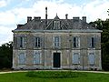
La Peyzie mansion
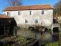
Jansou Mill
.JPG)

.JPG)


Web links
Commons : Lisle - collection of images, videos and audio files