Chantérac
|
Chantérac Chantairac |
||
|---|---|---|
|
|
||
| region | Nouvelle-Aquitaine | |
| Department | Dordogne | |
| Arrondissement | Périgueux | |
| Canton | Vallée de l'Isle | |
| Community association | Isle Vern Salembre en Périgord | |
| Coordinates | 45 ° 10 ′ N , 0 ° 27 ′ E | |
| height | 81-217 m | |
| surface | 18.94 km 2 | |
| Residents | 616 (January 1, 2017) | |
| Population density | 33 inhabitants / km 2 | |
| Post Code | 24190 | |
| INSEE code | 24104 | |
| Website | Chantérac | |
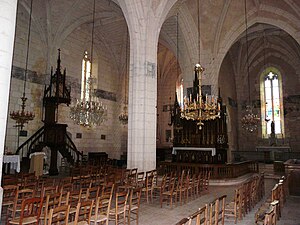
 Chantérac - Église Saint-Pierre-ès-Liens |
||
Chantérac ( Occitan Chantairac ) is a commune with 616 inhabitants (at January 1, 2017) in the Dordogne in the region Nouvelle-Aquitaine (before 2016 Aquitaine ). The community consists of the main town as well as some hamlets (hameaux) and individual farms (fermes) .
Location and climate
The place Chantérac is located on the river Le Roueix in the cultural landscape of the Périgord almost 30 km (driving distance) west of Périgueux at an altitude of about 145 m . The city of Bergerac is approximately 43 km south. The climate is moderate, rain (approx. 885 mm / year) falls over the year.
Population development
| year | 1800 | 1851 | 1901 | 1954 | 1999 | 2015 |
| Residents | 917 | 921 | 743 | 499 | 456 | 620 |
The continuous decline in population in the 20th century is mainly due to the mechanization of agriculture and the abandonment of small farms. The renewed increase in population since the 1980s is related to the relative proximity to the city of Périgueux.
economy
The community is traditionally oriented towards agriculture and forestry; the residents lived on a self-sufficient basis for centuries . Today fish farming and the rental of holiday apartments ( gîtes ) also play important roles in economic life.
history
The history of the settlement goes back to Gallo-Roman times; the first mention of the place under the name Chantairac comes from the year 1104. The current church was built in the 12th century on the site of a previous building from the 9th century. In the Hundred Years War (1337-1453) it was desecrated by soldiers and had to be rededicated. During the Huguenot Wars (1562–1598) it was again affected.
Attractions
- The Église Saint-Pierre-ès-Liens is dedicated to the Apostle Peter . The defensive-looking west tower dates back to the 12th century. In the 16th century, a larger aisle was added on the south side and the entire church was given a uniform rib vault with keystones adorned with coat of arms and high, late Gothic tracery windows . A painted black mourning ribbon ( liter funéraire ) surrounds the entire interior including the flat closed apse . The carved altar structure and the pulpit are from the 19th century. The church has been recognized as a monument historique since 1914 .
- Surroundings
- The Château de Chantérac , located about 1 km northwest of the village, dates from the 15th century; in the 17th and 18th centuries it was rebuilt and enlarged. It is privately owned and has been recognized as a Monument historique since 1959 .
literature
- Alain Connangle: Chantérac des Temps Anciens - de l'Age de Fer à la Révolution . 2017
Web links
Individual evidence
- ↑ Chantérac - map with altitude information .
- ↑ Chantérac / Périgueux - climate tables
- ↑ Chantérac - History and Church
- ↑ Chantérac - Église Saint-Pierre-ès-Liens in the Base Mérimée of the French Ministry of Culture (French)
- ↑ Chantérac - Château de Chantérac in the Base Mérimée of the French Ministry of Culture (French)
- ↑ Chantérac - Château de Chantérac

