
Val de Louyre and Caudeau
| Val de Louyre and Caudeau | ||
|---|---|---|
|
||
| region | Nouvelle-Aquitaine | |
| Department | Dordogne | |
| Arrondissement | Périgueux | |
| Canton | Périgord Central | |
| Community association | Le Grand Périgueux | |
| Coordinates | 44 ° 57 ' N , 0 ° 49' E | |
| height | 95-263 m | |
| surface | 82.12 km 2 | |
| Residents | 1,588 (January 1, 2017) | |
| Population density | 19 inhabitants / km 2 | |
| Post Code | 24510 | |
| INSEE code | 24362 | |

Val de Louyre et Caudeau is a commune with 1,588 inhabitants (as of January 1 2017) in the center of the department Dordogne in the region Nouvelle-Aquitaine . The municipality belongs to the Arrondissement of Périgueux and the Périgord Central .
It was created with effect from January 1, 2017 as Commune nouvelle through the amalgamation of the former Commune nouvelle Sainte-Alvère-Saint-Laurent Les Bâtons and the former municipality of Cendrieux . In the new municipality, all the originally independent municipalities exercise the status of a Commune déléguée . The administrative seat was in the village of Sainte-Alvère.
structure
| District | former INSEE code |
Area (km²) | Population (2017) |
|---|---|---|---|
| Sainte-Alvère (administrative headquarters) | 24362 | 32.42 | 791 |
| Cendrieux | 24092 | 30.23 | 584 |
| Saint-Laurent-des-Bâtons | 24435 | 19.47 | 213 |
geography
Val de Louyre et Caudeau is located about 30 kilometers south-southeast of Périgueux and about 20 kilometers east-northeast of Bergerac . The Louyre and the Caudeau have their source in the municipality .
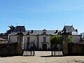
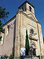
Attractions
- Saint-Maurice Castle from the 14th / 15th centuries century
- Remains of the castle of Sainte-Alvère from the 13th century, monument historique since 1949
- La Pommerie Castle from the 18th / 19th centuries Century, since 2002 Monument historique
- Saint-Pierre-ès-Liens church from the 18th century
- Saint-Maurice church from the 16th century
- Saint-Laurent church from the 19th century
- Saint-Jean-Baptiste church, fortified church, historic monument since 1925

Saint-Maurice Castle

Keep of the castle
La Pommerie Castle

Saint-Jean-Baptiste church
Saint-Pierre-ès-Liens church

Saint-Maurice Church
.JPG)


