
Sainte-Alvère
| Sainte-Alvère | ||
|---|---|---|

|
|
|
| local community | Val de Louyre and Caudeau | |
| region | Nouvelle-Aquitaine | |
| Department | Dordogne | |
| Arrondissement | Périgueux | |
| Coordinates | 44 ° 57 ' N , 0 ° 49' E | |
| Post Code | 24510 | |
| Former INSEE code | 24362 | |
| Incorporation | January 1, 2016 | |
| status | Commune déléguée | |

Sainte-Alvère is a town and commune Déléguée in the French commune of Val de Louyre et Caudeau with 791 inhabitants (as of January 1 2017) in the department of Dordogne in the region Nouvelle-Aquitaine .
geography
Sainte-Alvère is located about 20 kilometers east-northeast of Bergerac and about 35 kilometers south-southeast of Périgueux .
history
In 2016, Sainte-Alvère and the municipality of Saint-Laurent-des-Bâtons formed the Commune nouvelle Sainte-Alvère-Saint-Laurent Les Bâtons as Communes déléguées . On January 1, 2017, Sainte-Alvère became the new Commune nouvelle Val de Louyre et Caudeau together with Saint-Laurent-des-Bâtons and the municipality of Cendrieux as the Commune déléguée. The Commune nouvelle Sainte-Alvère-Saint-Laurent Les Bâtons was dissolved again at the same time. The commune of Sainte-Alvère was part of the Arrondissement of Périgueux and the canton of Périgord Central (until 2015: Canton of Sainte-Alvère ).
Population development
| year | 1962 | 1968 | 1975 | 1982 | 1990 | 1999 | 2006 | 2013 |
| Residents | 827 | 798 | 745 | 710 | 756 | 780 | 822 | 847 |
| Source: Cassini and INSEE | ||||||||
Attractions
- Remains of the castle of Sainte-Alvère from the 13th century, monument historique since 1949
- Saint-Pierre-ès-Liens church from the 18th century

Keep of the castle
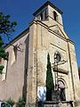
Saint-Pierre-ès-Liens church

