
Cendrieux
| Cendrieux | ||
|---|---|---|
|
||
| local community | Val de Louyre and Caudeau | |
| region | Nouvelle-Aquitaine | |
| Department | Dordogne | |
| Arrondissement | Périgueux | |
| Coordinates | 45 ° 0 ′ N , 0 ° 49 ′ E | |
| Post Code | 24380 | |
| Former INSEE code | 24092 | |
| Incorporation | January 1, 2017 | |
| status | Commune déléguée | |
| Website | http://www.cendrieux.fr/ | |
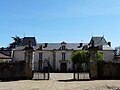
 Former town hall (Mairie) of Cendrieux |
||

Cendrieux ( Occitan : Sendrius ) is a town and commune Déléguée in the French commune of Val de Louyre et Caudeau with 584 inhabitants (as of January 1 2017) in the center of the department Dordogne in the region Nouvelle-Aquitaine .
On January 1st, 2017, the municipality of Cendrieux merged with Sainte-Alvère-Saint-Laurent Les Bâtons to form the new Commune nouvelle Val de Louyre et Caudeau. The municipality belonged to the Arrondissement of Périgueux and was part of the canton of Périgord Central (until 2015: Canton Vergt ).
geography
Cendrieux is 19 kilometers southeast of Périgueux and 38 kilometers northeast of Bergerac on the Louyre .
The municipality of Cendrieux was surrounded by the neighboring municipalities of Lacropte in the north, Saint-Félix-de-Reillac-et-Mortemart in the east and northeast, Journiac in the east and southeast, Saint-Avit-de-Vialard in the southeast, Sainte-Alvère in the south, Veyrines-de-Vergt to the west and Salon to the northwest.
Population development
| 1962 | 1968 | 1975 | 1982 | 1990 | 1999 | 2006 | 2012 | |
|---|---|---|---|---|---|---|---|---|
| 603 | 563 | 477 | 465 | 467 | 552 | 517 | 596 | |
| Source: Cassini and INSEE | ||||||||
Attractions
- Saint-Jean-Baptiste church, fortified church, historic monument since 1925
- La Pommerie Castle from the 18th / 19th centuries Century, since 2002 Monument historique
La Pommerie Castle

Saint-Jean-Baptiste church

