Saint-Avit-de-Vialard
|
Saint-Avit-de-Vialard Sench Avit de Vialars |
||
|---|---|---|

|
|
|
| region | Nouvelle-Aquitaine | |
| Department | Dordogne | |
| Arrondissement | Sarlat-la-Canéda | |
| Canton | Vallée de l'Homme | |
| Community association | Vallée de l'Homme | |
| Coordinates | 44 ° 57 ' N , 0 ° 52' E | |
| height | 113-251 m | |
| surface | 8.45 km 2 | |
| Residents | 160 (January 1, 2017) | |
| Population density | 19 inhabitants / km 2 | |
| Post Code | 24260 | |
| INSEE code | 24377 | |
| Website | www.saint-avit-de-vialard.fr/ | |
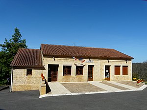
 Town hall (Mairie) of Saint-Avit-de-Vialard |
||
Saint-Avit-de-Vialard ( Occitan Sench Avit de Vialars ) is a southern French municipality with 160 inhabitants (as of January 1, 2017) in the southeast of the Dordogne department in the Nouvelle region, consisting of a main town and several hamlets (hameaux) and individual farmhouses -Aquitaine in the old cultural landscape of the Périgord . The municipality is part of the Sarlat-la-Canéda arrondissement and the Vallée de l'Homme .
location
Saint-Avit-de-Vialard is located about 38 kilometers east-northeast of Bergerac . Saint-Avit-de-Vialard is surrounded by the neighboring communities Val de Louyre et Caudeau in the north and west, Journiac in the north and east, Le Bugue in the east and south-east and Paunat in the south and south-west.
Population development
| year | 1962 | 1968 | 1975 | 1982 | 1990 | 1999 | 2006 | 2013 |
|---|---|---|---|---|---|---|---|---|
| Residents | 123 | 107 | 90 | 100 | 113 | 118 | 132 | 169 |
| Source: Cassini and INSEE | ||||||||
Attractions
- Saint-Avit church
Web links
Commons : Saint-Avit-de-Vialard - Collection of images, videos and audio files

