
Hautefort
|
Hautefort Autafòrt |
||
|---|---|---|
.svg)
|
|
|
| region | Nouvelle-Aquitaine | |
| Department | Dordogne | |
| Arrondissement | Sarlat-la-Canéda | |
| Canton | Haut-Périgord Noir | |
| Community association | Terrassonnais en Périgord Noir Thenon Hautefort | |
| Coordinates | 45 ° 16 ' N , 1 ° 9' E | |
| height | 145-271 m | |
| surface | 25.68 km 2 | |
| Residents | 928 (January 1, 2017) | |
| Population density | 36 inhabitants / km 2 | |
| Post Code | 24390 | |
| INSEE code | 24210 | |
| Website | http://www.hautefort.fr/ | |
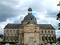
 Town hall (Mairie) of Hautefort |
||

Hautefort ( Occitan : Autafòrt ) is a commune with 928 inhabitants (as of January 1 2017) in the north of the department Dordogne in the region Nouvelle-Aquitaine . The municipality is part of the Haut-Périgord Noir (until 2015: chief town ( chef-lieu ) of the canton of Hautefort ) in the arrondissement of Sarlat-la-Canéda .
geography
Hautefort is 34 kilometers east-northeast of Périgueux . Hautefort is surrounded by the neighboring communities Cherveix-Cubas in the north and north-west, Boisseuilh in the north and east, Badefols-d'Ans in the south-east, Nailhac and Granges-d'Ans in the south, Temple-Laguyon and Sainte-Orse in the south-west and Tourtoirac in the West.
Population development
| year | 1962 | 1968 | 1975 | 1982 | 1990 | 1999 | 2006 | 2017 |
| Residents | 1002 | 1022 | 1142 | 1035 | 1048 | 1184 | 1120 | 928 |
| Sources: Cassini and INSEE | ||||||||
Attractions
- Saint-Aignan church, rebuilt in 1620
- Hautefort Castle , monument historique since 1958 (park since 1967)
- Hautefort Hospital, now a Museum of Medical History, since 1931 Monument historique
- Les Charreaux castle with pigeon tower from the 17th / 18th centuries century

Saint-Aignan church

Hautefort Castle
hospital

Part of the Les Charreaux castle


.JPG)
Personalities
- Bertran de Born (before 1140-around 1215), baron, troubadour and lord of Hautefort
- Eugène Le Roy (1836–1907), writer
- Guy des Cars (1911–1993), writer, buried here
- René Lavaud (1874–1955), literary scholar
Web links
Commons : Hautefort - collection of images, videos and audio files