
Thenon
| Thenon | ||
|---|---|---|
.svg)
|
|
|
| region | Nouvelle-Aquitaine | |
| Department | Dordogne | |
| Arrondissement | Sarlat-la-Canéda | |
| Canton | Haut-Périgord Noir (main town) | |
| Community association | Terrassonnais en Périgord Noir Thenon Hautefort | |
| Coordinates | 45 ° 8 ′ N , 1 ° 4 ′ E | |
| height | 136-285 m | |
| surface | 25.92 km 2 | |
| Residents | 1,263 (January 1, 2017) | |
| Population density | 49 inhabitants / km 2 | |
| Post Code | 24210 | |
| INSEE code | 24550 | |
 Look at Thenon |
||

Thenon ( Occitan : Tenon ) is a commune with 1,263 inhabitants (as of January 1 2017) in the north of the department Dordogne in the region Nouvelle-Aquitaine . The municipality is the main town ( bureau centralisateur ) of the Haut-Périgord Noir (until 2015: chief town ( chef-lieu ) of the canton Thenon ) in the arrondissement of Sarlat-la-Canéda .
geography
Thenon is 27 kilometers east-southeast of Périgueux . The Manoire rises in the municipality . Thenon is surrounded by the neighboring communities of Ajat in the north and west, Azerat in the north and east, Auriac-du-Périgord in the south-east, Bars in the south and Fossemagne in the south-west.
The A89 car route runs through the north of the municipality .
Population development
| year | Residents |
|---|---|
| 1962 | 1,130 |
| 1968 | 1,096 |
| 1975 | 1,253 |
| 1982 | 1,259 |
| 1990 | 1,339 |
| 1999 | 1,205 |
| 2006 | 1,290 |
| 2013 | 1,267 |
Attractions
- Saint-Martial church
- Ruins of the former 12th century castle complex of Thenon
- Market hall
- large pigeon house
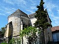
Saint-Martial church

Thenon Castle ruins
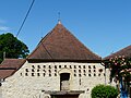
large pigeon house
.JPG)

