Castelnaud-la-Chapelle
| Castelnaud-la-Chapelle | ||
|---|---|---|
|
|
||
| region | Nouvelle-Aquitaine | |
| Department | Dordogne | |
| Arrondissement | Sarlat-la-Canéda | |
| Canton | Vallée Dordogne | |
| Community association | Domme Villefranche-du-Périgord | |
| Coordinates | 44 ° 49 ′ N , 1 ° 9 ′ E | |
| height | 51-283 m | |
| surface | 20.88 km 2 | |
| Residents | 457 (January 1, 2017) | |
| Population density | 22 inhabitants / km 2 | |
| Post Code | 24250 | |
| INSEE code | 24086 | |
| Website | http://www.castelnaud.com/fr/ | |
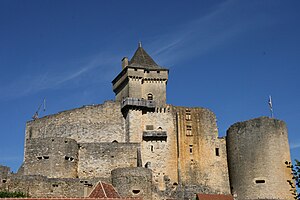
 Castelnaud Castle |
||
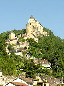
Castelnaud-la-Chapelle ( Occitan Castelnau e la Capela ) is a French municipality with 457 inhabitants (at January 1, 2017) in the Dordogne in the region Nouvelle-Aquitaine . The village is located on the banks of the Dordogne River , right at the confluence of its left tributary Céou . The picturesque silhouette of the place is determined by the Castelnaud castle , a medieval fortification from the 13th century. Castelnaud-la-Chapelle is a member of the Association of the Most Beautiful Villages in France .
Population development
| year | 1975 | 1982 | 1990 | 1999 | 2007 | 2016 | ||
| Residents | 380 | 374 | 408 | 426 | 461 | 464 | ||
| Sources: Cassini and INSEE | ||||||||
Web links
Commons : Castelnaud-la-Chapelle - collection of images, videos and audio files

