
Tamniès
| Tamniès | ||
|---|---|---|
|
||
| region | Nouvelle-Aquitaine | |
| Department | Dordogne | |
| Arrondissement | Sarlat-la-Canéda | |
| Canton | Sarlat-la-Canéda | |
| Community association | Sarlat-Black Perigord | |
| Coordinates | 44 ° 58 ' N , 1 ° 9' E | |
| height | 104-288 m | |
| surface | 19.09 km 2 | |
| Residents | 384 (January 1, 2017) | |
| Population density | 20 inhabitants / km 2 | |
| Post Code | 24620 | |
| INSEE code | 24544 | |
 Saint-Cybard Church |
||

Tamniès is a French commune with 384 inhabitants (as of January 1, 2017). It is located on a steep rock above the valley of the Grande Beune in Périgord noir in the Dordogne department .
The road to Tamniès leads up the hill in tight serpentines . The village church at the entrance to the village dates from the 13th century. A small museum with prehistoric tools and other finds was set up by the residents next to the entrance to the church . Opposite the buildings of a former monastery are still preserved.
The townscape is determined by old quarry stone houses with courtyards decorated with flowers and picturesque corners. In the square in front of the church, a hollow tree planted on July 14, 1790 commemorates the first anniversary of the French Revolution .

Church building - interior
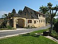
Building opposite the church

Stone-roofed hut by the roadside


Population development
| year | 1962 | 1968 | 1975 | 1982 | 1990 | 1999 | 2006 | 2016 |
| Residents | 333 | 316 | 282 | 284 | 313 | 317 | 301 | 383 |
| Sources: Cassini and INSEE | ||||||||
literature
- Susanne Böttcher (Ed.): Périgord, Dordogne, Limousin. (= The Green Guide. ). Travel-House-Media, Munich 2006, ISBN 3-8342-8995-7 , p. 304.