
Mazeyrolles
|
Mazeyrolles Maseiròlas |
||
|---|---|---|
|
||
| region | Nouvelle-Aquitaine | |
| Department | Dordogne | |
| Arrondissement | Sarlat-la-Canéda | |
| Canton | Vallée Dordogne | |
| Community association | Domme Villefranche-du-Périgord | |
| Coordinates | 44 ° 41 ′ N , 1 ° 1 ′ E | |
| height | 169-308 m | |
| surface | 29.65 km 2 | |
| Residents | 305 (January 1, 2017) | |
| Population density | 10 inhabitants / km 2 | |
| Post Code | 24550 | |
| INSEE code | 24263 | |
 Town Hall (Mairie) of Mazeyrolles |
||

Mazeyrolles ( Occitan : Maseiròlas ) is a southern French municipality with 305 inhabitants (as of January 1, 2017) in the extreme south of the Périgord noir and belongs to the arrondissement of Sarlat-la-Canéda and the canton of Vallée Dordogne .
location
Mazeyrolles is about 39 kilometers east-southeast of Bergerac . Mazeyrolles is surrounded by the neighboring communities Salles-de-Belvès and Sainte-Foy-de-Belvès in the north, Orliac in the northeast, Prats-du-Périgord in the east and northeast, Saint-Cernin-de-l'Herm in the east and southeast, Lavaur in the south, Blanquefort-sur-Briolance in the south and southwest, and Capdrot in the west.
Population development
| year | 1962 | 1968 | 1975 | 1982 | 1990 | 1999 | 2006 | 2013 |
| Residents | 443 | 442 | 389 | 378 | 380 | 343 | 357 | 338 |
| Source: Cassini and INSEE | ||||||||
Attractions
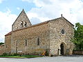
- Notre-Dame-de-la-Nativité church in Aigueparse, monument historique since 1940
- Saint Clair Church in Fontenilles
- Saint-Jean-Baptiste church in Mazeyrolles
- Saint-Jacques church in La Trappe from the 12th century
- Commander of the Order of St. John
- Manor of Aigueparse
- Mill from Le Greffier

Notre-Dame-de-la-Nativité church
Saint Clair Church
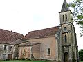
Saint-Jean-Baptiste church

Saint-Jacques church


literature
- Thorsten Droste : Périgord. Dordogne and Quercy. The landscapes in the heart of south-west France. DuMont, Cologne 1997, ISBN 3-7701-4003-6 .
Web links
Commons : Mazeyrolles - collection of images, videos and audio files