
Capdrot
| Capdrot | ||
|---|---|---|
|
||
| region | Nouvelle-Aquitaine | |
| Department | Dordogne | |
| Arrondissement | Bergerac | |
| Canton | Lalinde | |
| Community association | Communes des Bastides Dordogne-Périgord | |
| Coordinates | 44 ° 41 ′ N , 0 ° 55 ′ E | |
| height | 143-288 m | |
| surface | 43.72 km 2 | |
| Residents | 502 (January 1, 2017) | |
| Population density | 11 inhabitants / km 2 | |
| Post Code | 24540 | |
| INSEE code | 24080 | |
| Website | www.capdrot.fr | |
 town hall |
||

Capdrot is a French municipality with 502 inhabitants (at January 1, 2017) in the department of Dordogne in the region Nouvelle-Aquitaine (before 2016: Aquitaine ). The municipality belongs to the arrondissement Bergerac and the canton Lalinde (until 2015: canton Monpazier ).
The name is in the Occitan language Cap Dròt , which means "source of the Dropt" and indicates the geographic location.
The inhabitants are called Capdrotiens and Capdrotiennes or Capdrotois and Capdrotoises .
geography
Capdrot is located about 40 km southeast of Bergerac in the Bergeracois region of the historic Périgord province on the southern edge of the department.
Capdrot is surrounded by the neighboring communities:
| Marsals |
Saint-Marcory Pays de Belvès |
Salles-de-Belvès |
| Monpazier |
.svg)
|
Mazeyrolles |
| Gaugeac | Soulaures |
Capdrot lies in the catchment area of the Garonne River .
The Dropt , a tributary of the Garonne, has its source in Capdrot, as do its tributaries, the Ruisseau du Moulin Neuf and the Ruisseau de Moulinio. The Soulauret, another tributary of the Dropt, has its source in the southern neighboring municipality of Soulaures and crosses the area of the municipality of Capdrot.
history
The place has been inhabited for a very long time, as evidenced by an archaeological site with artefacts from prehistory and discoveries made in 1994 near the church. A monumental base of a statue , Roman coins, including one depicting the Roman emperor Probus , and a small head made of gagat , dating from the third century, were found there. It is believed that a Roman villa and a Roman temple were located on the site of the current church .
After Christianization had taken hold in the region, a first church made of wood and clay was built on the site of the temple in the seventh century. In 849, Vikings from Denmark looted the church and set it on fire. It was rebuilt from stone with exposed brickwork and Romanesque vaults . The choir of this simple church was covered with a groin vault and forms the crypt of today's church. In it could murals with depictions of paws crosses are preserved in part. In the Middle Ages , Capdrot was one of the most important religious centers of the Périgord. Before the year 1000, the archpriesthood ruled over 60 parishes. At the beginning of the 12th century the parish church of Capdrot hid a "black" virgin, a veneration of Mary that arose in many places between the 10th and 13th centuries. Little by little the church became a place of pilgrimage where thousands of believers gathered. Numerous pilgrims on the Way of St. James to or from Santiago de Compostela also made a stop in Capdrot. The influx of pilgrims and pilgrims required the construction of a larger church with three apses in the 12th century, which enclosed the earlier church. The canons ' apartments , the refectory , the chapter house and the library were located north of the church building. The convent building was connected to the church via an ogival entrance in the north apse. At the same time, the 12th century must have been associated with dangers, because a 1.80 m thick wall was built around the church square. A technical improvement of the plows and favorable climatic conditions brought an increase in the population. Capdrot had 3,000 inhabitants around 1300.
Pope John XXII. founded a monastery on May 23, 1318 . The chapter received a vote to appoint the Bishop of Sarlat . This did not last long and Capdrot was also drawn into the dispute within the framework of the Avignon papacy , because on May 29, 1343 the chapter lost this right to vote. The size of the community decreased in the face of two years of poverty in 1333 and 1334, with the beginning of the Hundred Years War and the plague epidemic of 1349, which alone wiped out two thirds of the village population. Capdrot had no city walls and was plundered five times, sometimes by British and sometimes by French troops. The great frost of 1363, which damaged nut trees and chestnuts , and the devastation of the monastery further weakened Capdrot. In 1390 the church was destroyed by fire and the Romanesque bell tower collapsed. As the situation gradually improved, another wave of plague hit the place at the beginning of the 15th century. The earthquake of 1490 destroyed part of the dwellings of the canons and damaged the pen. The canons asked the bishop to move to Monpazier, which many subsequently carried out.

In the 16th century, more people moved into the farms and houses in the center. Viticulture flourished, iron sold well and handicrafts developed despite the tax increases by the French King Francis I , who needed money to finance his wars. The Huguenot Wars destroyed all positive developments. Protestant troops under the leadership of the two Calvinists La Clauzade and Lauzerte attacked the church in October 1574, imprisoned part of the villagers and three canons there, and set the church on fire after taking 36 gold chalices with them. The rest of the village also started a fire that raged for three days. The parish church was rebuilt one more time, albeit on a smaller scale. The archpriest Johannes Cambon directed the construction of the new nave on the ruins in 1588. In the 17th century the amount of taxes once again exceeded what the peasants were able to give. Julien Buffarot, a weaver from Capdrot, made himself the spokesman for a peasant uprising . Bernard de Nogaret de La Valette d'Épernon was called to suppress the rebellion of Cardinal Richelieu . Julien Buffarot was captured without a fight at the head of his 4,000 men by a lieutenant of the Duke of Épernon and sentenced to death by wheeling on August 6, 1637 .
Until the second half of the 18th century, the village suffered from renewed waves of the plague, but above all from long, hard winters and famine. While the climate normalized, iron production came under pressure, as iron imported from England could be bought more cheaply than domestic iron due to a free trade introduced in 1774. The blacksmiths tried to compensate for this with quantity. The need for charcoal increased, extensive clearing of the forests began and the risk of famine increased because the number of chestnut trees also decreased. Fortunately, the potato and corn found their way into agriculture. In 1775 a wave of foot-and-mouth disease reached the village. All cattle had to be slaughtered and were no longer available for farming, and the prices for grain and bread rose. The French Revolution , however, had no major impact on everyday life in Capdrot.
In 1875 phylloxera attacked the community's vineyards, which until then had covered an area of around 1,000 hectares. Hundreds of people lost their jobs and left Capdrot. Between 1920 and 1945 the cultivation of tobacco found its way into agriculture and every farm had its own drying facility. At the beginning of the Second World War , many residents of the Alsatian Rhinau fled to Capdrot. During the German occupation of France in World War II , several members of the Resistance were arrested in what was then a restaurant near the parish church . The German soldiers then set fire to Péchegut Castle northeast of the center of Capdrot, where other Maquis were arrested. On May 21, 1944, several residents of Capdrot were arrested in an action against the Resistance.
Toponymy
Toponyms and mentions of Capdrot were:
- Capdracum (1289, Gironde Archives),
- Capdrotum (1317),
- Capdrot (1750, 1793 and 1801, map from Cassini , Notice Communale or Bulletin des Lois ).
Population development
After records began, the population rose to a peak of 1,335 in the mid-19th century. In the period that followed, the size of the community sank to 435 inhabitants during short recovery phases until the 1960s, before a level of around 500 inhabitants set in, which is still maintained today.
| year | 1962 | 1968 | 1975 | 1982 | 1990 | 1999 | 2006 | 2010 | 2017 |
|---|---|---|---|---|---|---|---|---|---|
| Residents | 505 | 435 | 469 | 467 | 502 | 507 | 485 | 508 | 502 |

Attractions
Parish Church of Notre-Dame-de-l'Assomption

The building is made of medium brickwork of limestone built from close located quarries date back to the Valley of Vérone. On the southern wall, especially on the right-hand side, despite repairs, displacements of the masonry can be seen. They are the result of the earthquake of 1490. In the southern facade, an arched entrance allows access to the interior of the church. This access was subsequently incorporated into the facade of the traditional entrance portal on the west side. A round bell tower, as shown on the seal of the monastery, once rose above it. Today's square bell tower has round arched windows and sound openings and a helmet . A protrusion of the transept can be seen on the north side . The arch visible on it, now walled up, once connected a north aisle with the last yoke in front of the choir. The east side is an apse with five windows that is flat from the outside. The three middle windows belong to the original semicircular apse, the two outer windows to the two apsidioles, which are embedded together in a masonry. The central window in the longitudinal axis is integrated into a buttress , an architectural element that is often seen in the region. Inside, the main nave with a length of two bays and the breadth of one bay opens into the transept. This has a width of three bays, the two northern bays being arched. The apse and apsidioles are provided with apse domes. The southern apse rests on a lower chapel that looks like a crypt. It is the apse of the first church and was preserved and integrated into the new building in the 17th century. In the transept a cylindrical column rests on a base from Gallo-Roman times. In the southwest corner of the same arm of the transept there is a fountain from the time of the Roman temple, which proves that water has been worshiped since ancient times. On the wall opposite the crypt there is a wall painting that dates back to the 16th century and depicts the baptism of Jesus by John the Baptist in the Jordan . At the entrance to the left apseid there is a column with a capital , which obviously does not have a supporting function. It is believed that it was part of the entrance portal of the earlier church.

South side
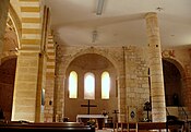
View in the transept of the apse and apsidioles

South apsidiole with entrance to the crypt

crypt

Northern apseidole

The capital of the column at the entrance to the northern apse-idole

North wall of the nave


Economy and Infrastructure
Forestry, animal husbandry and agriculture are the main economic factors in the municipality.

total = 60
education
The municipality has a public pre-school and elementary school with 24 students in the 2018/2019 school year.
traffic
The Route départementale 660, the former Route nationale 660 , crosses the territory of the municipality and connects Capdrot in the west with Monpazier and beyond with the Bergerac – Sarlat-la-Canéda axis, in the east with Mazeyrolles and further on with Cahors . Capdrot can also be reached via routes départementales 2, 53, 53E3 and 58.
Personalities
Julien Buffarot, who died in Monpazier on August 6, 1637, was the leader of one of the peasant revolts in the 16th and 17th centuries.
Web links
Individual evidence
- ↑ Le nom occitan des communes du Périgord ( fr ) Départementrat des Dordogne. Retrieved October 14, 2018.
- ↑ a b Capdrot ( fr ) Conseil régional d'Aquitaine. Archived from the original on September 9, 2016. Retrieved October 14, 2018.
- ↑ Dordogne ( fr ) habitants.fr. Retrieved October 14, 2018.
- ↑ Ma commune: Capdrot ( fr ) Système d'Information sur l'Eau du Bassin Adour Garonne. Retrieved October 14, 2018.
- ↑ Jacques Magimel-Pelonnier: CAPDROT, LIEU DE MÉMOIRE ( fr , PDF) Groupe Archéologique Mons-Paciarus. 2003. Retrieved October 14, 2018.
- ↑ Bernard De Jesus: Histoire de la Collégiale de Capdrot ( fr , PDF) Groupe Archéologique Mons-Paciarus. 1985. Retrieved October 14, 2018.
- ↑ Elisée Cérou: Histoire des Croquants en Périgord ( fr , PDF) Groupe Archéologique Mons-Paciarus. 1987. Retrieved October 14, 2018.
- ^ Paul Vicomte de Gourgues: Dictionnaire topographique du département de la Dordogne ( fr ) In: Dictionnaire topographique de la France . Imprimerie nationale. P. 54, 1873. Retrieved October 14, 2018.
- ^ France 1750 ( en ) David Rumsey Map Collection: Cartography Associates. Retrieved October 14, 2018.
- ↑ a b Notice Communale Capdrot ( fr ) EHESS . Retrieved October 14, 2018.
- ↑ Populations légales 2015 Commune de Capdrot (24080) ( fr ) INSEE . Retrieved October 14, 2018.
- ^ Jean-Pierre Verdon: L'EGLISE DE CAPDROT ( fr , PDF) Groupe Archéologique Mons-Paciarus. 2004. Retrieved October 14, 2018.
- ↑ Eglise Notre-Dame-de-l'Assomption ( fr ) Observatoire du patrimoine religieux. Retrieved October 14, 2018.
- ↑ Mairie de Capdrot ( fr ) Pays de Bergerac Tourisme. Retrieved October 14, 2018.
- ↑ Mairie de Capdrot ( fr ) Pays de Bergerac Tourisme. Retrieved October 14, 2018.
- ↑ Caractéristiques des établissements en 2015 Commune de Capdrot (24080) ( fr ) INSEE . Retrieved October 14, 2018.
- ^ École maternelle et élémentaire ( fr ) National Ministry of Education. Retrieved October 14, 2018.